
Simpson Desert facts for kids
Quick facts for kids Simpson Desert |
|
|---|---|

Dunes at the edge of the Simpson Desert
|
|

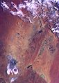
The IBRA boundaries of the Simpson Desert
|
|
| Area | 176,500 km2 (68,100 sq mi) |
| Geography | |
| Country | Australia |
| States | Northern Territory, Queensland and South Australia |

The Simpson Desert is a huge, very dry area mostly found in the Northern Territory of Australia. Parts of it also stretch into northern South Australia and western Queensland. This vast desert covers about 176,500 square kilometers, which is roughly 2.3% of Australia's total land.
The Simpson Desert is famous for its giant red sand dunes. These dunes can be up to 40 m (44 yd) tall and 190 km (118 mi) long. They are usually about 1 km (1 mi) apart. The desert receives very little rain, less than 150 millimeters each year.
Most of the time, there is no surface water. However, after heavy rains, temporary rivers can flow into lakes that are usually dry. Temperatures here can be extreme. In summer, it can get hotter than 50 degrees Celsius, while in winter, temperatures can drop below freezing.
Early explorers like Charles Sturt visited the area in 1845. The desert was named in 1929 after A.A. Simpson, who was the President of the Royal Geographical Society of Australasia. The first European to cross the entire desert was Ted Colson in 1936.

There are no proper roads that cross the desert. Instead, there are many tracks that were made in the 1960s and 1970s when people were looking for gas and oil. These tracks include the French Line, the Rig Road, and the QAA Line. Only well-equipped four-wheel drive vehicles should attempt to use these tracks, and they must carry extra fuel and water.
Towns near the edge of the Simpson Desert include Oodnadatta to the southwest and Birdsville in the east. On the western side, you'll find the Mount Dare hotel and shop. Before 1980, a railway line ran along the western edge of the desert. Inside the Simpson Desert, people visit interesting places like the ruins at Dalhousie Springs, the Purnie Bore wetlands, Approdinna Attora Knoll, and Poeppel Corner. Poeppel Corner is a special spot where Queensland, South Australia, and the Northern Territory meet.
Contents
History of the Simpson Desert
Aboriginal People and the Desert
Aboriginal people have lived in the Simpson Desert for at least 5,000 years and still live there today. The Wangkangurru people, for example, used special hand-dug wells called mikiri. They relied on these wells for water long before European settlers arrived, until a very bad drought called the Federation Drought.
European Exploration and Crossings


The explorer Charles Sturt was the first European to see the desert between 1844 and 1846. In 1880, a surveyor named Augustus Poeppel was marking the border between Queensland and South Australia. He accidentally placed the border post about 300 meters too far west.
In 1884, another surveyor, Larry Wells, moved the post to its correct spot. This spot, where Queensland, South Australia, and the Northern Territory meet, is now known as Poeppel Corner. In 1886, surveyor David Lindsay explored the desert from the west. With the help of a Wangkangurru Aboriginal man, he found and recorded nine native wells.
In 1936, Ted Colson became the first non-Indigenous person to cross the entire desert. He did this by riding camels. The desert was named by Cecil Madigan after Alfred Allen Simpson. Mr. Simpson was an Australian businessman and a geographer. He was also the owner of the Simpson washing machine company.
In September 1962, geologist Reg Sprigg, his wife Griselda, and their two children made history. They were the first to cross the desert in a vehicle.
Amazing Journeys Across the Desert
Many people have challenged themselves to cross the Simpson Desert in unique ways.
- In 1980, Bob Beer was the first person to run across the desert. He ran 420 km in 6.5 days. A documentary called “The Runner” was made about his journey.
- In 1984, Dennis Bartel was the first white man to walk solo and without support across the desert from west to east. He walked 390 km in 24 days, using old Aboriginal wells for water.
- In 2006, Lucas Trihey was the first non-Indigenous person to walk across the desert through its geographical center. He did this without support, pulling all his gear in a two-wheeled cart.
- In 2008, Michael Giacometti completed the first and only east-to-west walk across the Simpson Desert. He walked solo and unsupported, pulling his equipment in a cart.
- Also in 2008, Belgian Louis-Philippe Loncke became the first non-Indigenous person to cross the desert from north to south on foot, unsupported, and through the geographical center.
- In 2016, explorer Sebastian Copeland and Mark George completed the longest unsupported west-to-east crossing. They walked 404 miles in 26 days, linking several famous tracks.
In 1967, the Queensland government created the Munga-Thirri National Park, which helps protect this special area.
Visiting the Simpson Desert
The desert is a popular place for tourists, especially during the cooler winter months. Some popular spots to visit include the ruins and natural springs at Dalhousie Springs. Other attractions are the Purnie Bore wetlands, Approdinna Attora Knoll, and Poeppel Corner.
Because of the extreme summer heat and the dangers for unprepared drivers, the Department of Environment and Natural Resources decided to close the Simpson Desert during summer since 2008–2009. This helps keep people safe.
Another big event is the Big Red Bash, which is called the most remote music festival on Earth. This festival features concerts and a fun drag race across the sand dunes. It helps raise money for the Royal Flying Doctor Service of Australia.
You can also cross the desert by bicycle! The Simpson Desert Bike Challenge takes place every year in September.
Climate and Weather
The Simpson Desert has a very hot and dry desert climate. It gets very little rain, averaging only about 150 millimeters per year, mostly in summer. Summer temperatures can reach almost 50 degrees Celsius, and large sand storms are common. Winters are usually cool, but sometimes it can get surprisingly hot even in July.
In 2009–2010, the desert received some of the heaviest rain in decades. This caused the Simpson Desert to become full of life and color. In March 2010, Birdsville got more rain in 24 hours than it usually gets in a whole year! This huge amount of water flowed into western river systems, eventually reaching Lake Eyre. In 2010, scientists even found the paths of ancient rivers hidden beneath the desert.
Plants and Animals


The plants in the Simpson Desert are special because they can survive in very dry conditions. These include tough shrubs and grasses, especially Zygochloa paradoxa grass, which helps hold the sand dunes together. You'll also find spinifex and other strong grasses growing between the dunes.
The animals here are also adapted to the hot, dry environment and occasional floods.
- One interesting animal is the water-holding frog (Litoria platycephala).
- Many reptiles live among the desert grasses.
- Mammals found only in this desert include the kowari (Dasycercus byrnei).
- Birds like the grey grasswren (Amytornis barbatus) and Eyrean grasswren (Amytornis goyderi) also call the desert home.
Seasonal wetlands like Lake Eyre and the Coongie Lakes are very important for fish and birds. They are especially good breeding grounds for waterbirds when rivers like Cooper Creek, Strzelecki Creek, and the Diamantina River flood. These wetlands attract birds such as the freckled duck (Stictonetta naevosa), musk duck (Biziura lobata), silver gull (Larus novaehollandiae), Australian pelican (Pelecanus conspicillatus), great egret (Ardea alba), glossy ibis (Plegadis falcinellus), and banded stilt (Cladorhynchus leucocephalus).
The natural springs (mound springs) that come from the Great Artesian Basin are also vital habitats. They support many unique plants, fish, snails, and other small creatures.
Because the desert is so hard to live in, most of its natural plant life is still intact. This means that farming doesn't threaten the habitats. However, introduced animals like rabbits and wild camels can cause damage. The only human activity within the main desert area has been building gas pipelines. The areas around the desert are used for cattle grazing, and there are towns like Innamincka. The mound springs and other waterholes are sensitive and can be damaged if too many people use them.
Protected areas in this region include the Simpson Desert, Goneaway, Lochern, Bladensburg, Witjira and Kati Thanda-Lake Eyre National Parks. The Innamincka Regional Reserve and the Munga-Thirri–Simpson Desert National Park also help protect this unique environment.
Images for kids
-
Simpson Desert visible dune lines and Lake Eyre at bottom left
.jpg)
See also
 In Spanish: Desierto de Simpson para niños
