Oodnadatta facts for kids
Quick facts for kids OodnadattaSouth Australia |
|||||||||||||||
|---|---|---|---|---|---|---|---|---|---|---|---|---|---|---|---|

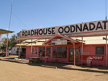
The Pink Roadhouse at Oodnadatta
|
|||||||||||||||
| Established | 30 October 1890 (town) 8 February 2001 (locality) |
||||||||||||||
| Postcode(s) | 5734 | ||||||||||||||
| Elevation | 121 m (397 ft)(railway station) | ||||||||||||||
| Time zone | ACST (UTC+9:30) | ||||||||||||||
| • Summer (DST) | ACST (UTC+10:30) | ||||||||||||||
| Location |
|
||||||||||||||
| LGA(s) | Pastoral Unincorporated Area | ||||||||||||||
| Region | Far North | ||||||||||||||
| State electorate(s) | Giles | ||||||||||||||
| Federal Division(s) | Grey | ||||||||||||||
|
|||||||||||||||
|
|||||||||||||||
| Footnotes | Locations Adjoining localities |
||||||||||||||
Oodnadatta is a small, remote town in the outback of South Australia. It is located about 1043 kilometres (648 miles) north-west of Adelaide, the state capital. The town sits at an altitude of 112 metres (367 feet) above sea level.
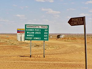
A famous unsealed road, the Oodnadatta Track, runs through the town. This road is very popular with tourists who want to explore the Australian outback. Oodnadatta has a hotel, a caravan park, a post office, and general stores. It also has a police station, a small hospital, and places to get fuel and minor car repairs. The old railway station is now a museum.
From the 1880s to the 1930s, Oodnadatta was an important base for camel drivers. These drivers and their camels helped transport goods when the railway was being built. They also carried supplies along outback tracks before proper roads existed. After the railway line was removed, Oodnadatta changed. It became a home for Aboriginal families who bought empty houses left by railway workers.
Contents
What Does the Name Oodnadatta Mean?
The name Oodnadatta has two possible meanings. One idea is that it comes from an Aboriginal word, utnadata. This word means "yellow blossom of the mulga tree." However, mulga trees do not grow near the town.
Another meaning suggested is coodnadatta or kudnadatta. This name refers to something "rotten" or "excreta" being "there."
History of Oodnadatta
For thousands of years, Aboriginal tribes visited the area where Oodnadatta is now. It was a reliable water source along their trade routes. There was no permanent settlement at Oodnadatta itself.
John McDouall Stuart explored this region in 1859. His path was mostly followed by the people who surveyed the Australian Overland Telegraph Line. This important telegraph line was finished in 1872. The route for the Central Australia Railway also followed this path. This was because steam trains needed a constant water supply.
From 1891, Oodnadatta was a key station on the railway. The line closed in 1981. A new railway, the Adelaide–Darwin rail corridor, opened in 2004. It runs about 160 km (100 mi) to the west, bypassing Oodnadatta.
Telegraphs, Camels, and Railways
Angle Pole is a spot near Oodnadatta where the telegraph line changed direction. It is close to The Peake cattle station. The ruins of the Peake telegraph station can still be seen there today.
By the 1880s, camel trains were using the telegraph route. Many of these trains were led by "Afghan" cameleers. These cameleers came from different parts of the Indian subcontinent. They were brought to Australia to haul goods into Central Australia for early settlers. Many cameleers settled in Oodnadatta and Marree. Some had families, and some married Aboriginal women.
In the 1880s, Angle Pole was chosen as the end point for the Great Northern Railway. When the railway was built, a town was created here. In October 1890, it was officially named Oodnadatta.
The town remained the end of the Great Northern Railway until 1929. That's when the line was extended to Alice Springs. The railway's name then changed to the Central Australia Railway. The railway had narrow tracks, and trains often faced delays. This was due to floods and other damage to the track. A new railway line was built to the west, bypassing Oodnadatta. It opened in October 1980.
Oodnadatta During World War II
Oodnadatta was busiest during World War II. The Australian Army and the Royal Australian Air Force set up facilities there. These facilities helped service troop trains and aircraft traveling to Darwin.
Oodnadatta in the 21st Century
Today, tourists traveling the Oodnadatta Track and the mining industry help keep the town active. The Aboriginal school is the biggest employer in Oodnadatta.
In 2018, the government announced a big upgrade to the Oodnadatta Track. This was to make it better for tourists and truck drivers. It is an important route for freight and cattle transport.
In 2023, a special water plant was installed in Oodnadatta. This reverse osmosis plant cleans the town's drinking water. Before this, the town used untreated water from underground. The government had warned people not to drink it due to a rare brain infection risk.
Getting to Oodnadatta and What to Find There
You can reach Oodnadatta by an unsealed road from Coober Pedy. You can also use the unsealed Oodnadatta Track from Marree to Marla. From the north, you can come via Finke/Aputula, NT. This northern route is part of the "Old Ghan Heritage Trail."
The Pink Roadhouse is a famous spot in Oodnadatta. It is painted bright pink! It offers petrol, a general store, and meals. You can also find different types of accommodation and post office services there. The Transcontinental Hotel, built in the 1890s, is nearby. There is also a caravan park.
Oodnadatta gets mail service twice a week. This is done by the Coober Pedy Oodnadatta One Day Mail Run. The mail truck also carries some general goods and passengers. The town has a sealed air strip that is 1290 metres (1410 yards) long. It was first built during World War II.
Historic Buildings in Oodnadatta
The old Oodnadatta railway station is now a museum. It is listed on the South Australian Heritage Register because of its historical importance.
Oodnadatta Aboriginal School
The Oodnadatta Aboriginal School is located on Kutaya Terrace. It is run by the Government of South Australia. The school offers education from Reception (like kindergarten) up to Year 12. In 2018, the school had 14 students. Most of them (86%) were Indigenous. There were three teachers at the school.
Climate in Oodnadatta
Oodnadatta has a hot desert climate. This means it has very hot summers and mild winters. The town is in the Outback, so temperatures change a lot between seasons. Average high temperatures are around 38.0 °C (100.4 °F) in January. In July, they are around 19.8 °C (67.6 °F). Average low temperatures range from 23.2 °C (73.8 °F) in January to 5.9 °C (42.6 °F) in July.
The average yearly precipitation (rain) is very low: 171.8 mm (6.76 in). This rain falls over about 34 days a year. The town is very sunny, with many clear days. A large sign in Oodnadatta proudly says it is "The driest town, the driest state of the driest Continent."
Extreme temperatures have been recorded in Oodnadatta. The lowest was −4.0 °C (24.8 °F) on July 16, 1979. The highest was 50.7 °C (123.3 °F) on February 20, 1983. This was the highest reliably measured temperature in Australia for a long time. This record was equaled on January 13, 2022, in Onslow, Western Australia.
| Climate data for Oodnadatta (27º39'36"S, 135º27'00"E, 117 m AMSL) (1939-2024 normals and extremes) | |||||||||||||
|---|---|---|---|---|---|---|---|---|---|---|---|---|---|
| Month | Jan | Feb | Mar | Apr | May | Jun | Jul | Aug | Sep | Oct | Nov | Dec | Year |
| Record high °C (°F) | 50.7 (123.3) |
46.8 (116.2) |
44.9 (112.8) |
42.1 (107.8) |
35.0 (95.0) |
32.8 (91.0) |
32.2 (90.0) |
39.4 (102.9) |
40.7 (105.3) |
45.4 (113.7) |
47.4 (117.3) |
48.4 (119.1) |
50.7 (123.3) |
| Mean daily maximum °C (°F) | 38.0 (100.4) |
36.7 (98.1) |
33.9 (93.0) |
28.6 (83.5) |
23.3 (73.9) |
19.9 (67.8) |
19.8 (67.6) |
22.3 (72.1) |
26.8 (80.2) |
30.5 (86.9) |
33.8 (92.8) |
36.5 (97.7) |
29.2 (84.5) |
| Mean daily minimum °C (°F) | 23.2 (73.8) |
22.4 (72.3) |
19.4 (66.9) |
14.5 (58.1) |
9.8 (49.6) |
6.5 (43.7) |
5.9 (42.6) |
7.5 (45.5) |
11.6 (52.9) |
15.2 (59.4) |
18.7 (65.7) |
21.4 (70.5) |
14.7 (58.4) |
| Record low °C (°F) | 11.7 (53.1) |
12.8 (55.0) |
9.5 (49.1) |
3.8 (38.8) |
0.9 (33.6) |
−2.6 (27.3) |
−2.2 (28.0) |
−0.3 (31.5) |
2.2 (36.0) |
5.1 (41.2) |
9.6 (49.3) |
11.3 (52.3) |
−2.6 (27.3) |
| Average precipitation mm (inches) | 24.1 (0.95) |
29.4 (1.16) |
13.8 (0.54) |
11.1 (0.44) |
11.8 (0.46) |
11.7 (0.46) |
8.9 (0.35) |
8.0 (0.31) |
10.0 (0.39) |
13.4 (0.53) |
12.8 (0.50) |
16.9 (0.67) |
171.8 (6.76) |
| Average precipitation days (≥ 0.2 mm) | 3.1 | 2.6 | 2.4 | 2.3 | 2.6 | 3.2 | 2.4 | 2.4 | 2.6 | 3.6 | 3.7 | 3.5 | 34.4 |
| Average afternoon relative humidity (%) | 20 | 23 | 22 | 25 | 32 | 37 | 34 | 28 | 23 | 19 | 18 | 18 | 25 |
| Average dew point °C (°F) | 7.0 (44.6) |
8.2 (46.8) |
6.4 (43.5) |
4.9 (40.8) |
4.3 (39.7) |
3.5 (38.3) |
2.0 (35.6) |
0.9 (33.6) |
1.1 (34.0) |
1.2 (34.2) |
2.9 (37.2) |
4.7 (40.5) |
3.9 (39.1) |
| Mean monthly sunshine hours | 337.9 | 296.6 | 313.1 | 273.0 | 244.9 | 231.0 | 254.2 | 275.9 | 291.0 | 316.2 | 321.0 | 341.0 | 3,495.8 |
| Percent possible sunshine | 80 | 81 | 83 | 80 | 73 | 74 | 77 | 80 | 81 | 80 | 79 | 79 | 79 |
| Source: Bureau of Meteorology (1939-2024 normals and extremes) | |||||||||||||
How Oodnadatta is Governed
Oodnadatta is part of the federal Division of Grey. It is also in the state electoral district of Stuart. The town is located in the Pastoral Unincorporated Area of South Australia. This means it doesn't have its own local government. Instead, a state government agency called the Outback Communities Authority provides services to the community.
Oodnadatta on Mars
The name Oodnadatta has even been used for a crater on the planet Mars!
See also
 In Spanish: Oodnadatta para niños
 | Aurelia Browder |
 | Nannie Helen Burroughs |
 | Michelle Alexander |


