Port Augusta facts for kids
Quick facts for kids Port AugustaSouth Australia |
|||||||||
|---|---|---|---|---|---|---|---|---|---|

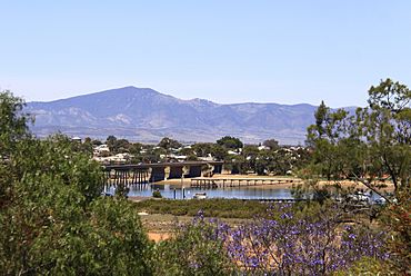
View across Spencer Gulf to Mount Brown
|
|||||||||
| Established | 1852 | ||||||||
| Postcode(s) | 5700 | ||||||||
| Location |
|
||||||||
| LGA(s) | City of Port Augusta | ||||||||
| State electorate(s) | Stuart Giles |
||||||||
| Federal Division(s) | Grey | ||||||||
|
|||||||||
Port Augusta is a coastal city in South Australia. It is about 310 kilometres (190 mi) by road from Adelaide, the state capital. The city's original name in the Barngarla language is Goordnada.
Most of Port Augusta is on the eastern side of Spencer Gulf. This includes the city centre and suburbs like Stirling North. Some homes are also by the sea at Commissariat Point, Blanche Harbor, and Miranda. The suburb of Port Augusta West is on the western side of the gulf, on the Eyre Peninsula. In 2021, about 13,515 people lived in these areas.
Port Augusta used to be a busy seaport. Today, it helps local farms and supports many mines in the northern part of South Australia. For many years, making electricity was a big industry here. Its coal power stations closed in 2019. A new solar farm started working in 2020.
Contents
History of Port Augusta
Port Augusta is part of the traditional land of the Aboriginal Nukunu people. Their local language is Barngarla. The last person who spoke Barngarla died in 1964. However, people are now working to bring the language back to life. They are using a large dictionary from the 1840s to help them.
The area has a natural harbour. It was officially named on May 24, 1852. Two men, Alexander Elder and John Grainger, found it while on a ship called Yatala. The port was named after Augusta Sophia, Lady Young. She was the wife of the Governor of South Australia, Sir Henry Edward Fox Young.
Plants and Animals in Port Augusta
The waters around Port Augusta are home to many different marine animals. Some species live there all the time. Others, like whales, sunfish, swordfish, and turtles, visit sometimes.
Who Lives in Port Augusta?
In 2021, Port Augusta and its nearby areas had 13,515 people. This made it the fourth largest urban area outside of Adelaide. About 83.4% of the people were born in Australia. Also, 20.8% were Aboriginal or Torres Strait Islander people.
Many people in Port Augusta work in community services or as professionals. The average household income was about A$1277 per week.
Getting Around Port Augusta
Port Augusta is at the top of Spencer Gulf. This gulf acts like a natural barrier for travel by land. Because of this, Port Augusta is known as the "crossroads of Australia." It is where major roads and railways meet.
Road Travel in Port Augusta
Port Augusta is at the start of several important highways:
- The Eyre Highway goes west to Perth.
- The Augusta Highway goes south to Adelaide.
- The Stuart Highway goes north to Darwin.
Almost all road traffic crossing southern Australia passes through Port Augusta. You can also catch a coach (bus) service from Port Augusta to other towns and Adelaide twice a day.
Train Travel in Port Augusta
In 1878, Port Augusta became the starting point for a new railway line. This line was planned to go all the way north to Darwin, about 2,500 kilometres (1,600 mi) away. The Australian government took over this railway in 1911. They called it the "Central Australia Railway" in 1926. By 1929, it reached Alice Springs.
Between 1913 and 1917, another long railway was built. This was the Trans-Australian Railway, which went east to west. It connected Port Augusta to Kalgoorlie in Western Australia. This railway was built with a wider track size. This meant trains had to change tracks in Port Augusta until the wider track was extended to Port Pirie in 1937. The full railway line from Adelaide to Darwin was finished in 2003.
Port Augusta is a stop for two famous long-distance trains:
- The Indian Pacific travels between the east and west coasts.
- The Ghan travels between Adelaide and Darwin.
The Pichi Richi Railway is a special heritage railway. It started in the 1970s on an old part of the Central Australia Railway. In 2001, a new line was built to connect it to the centre of Port Augusta. Now, you can take half-day or full-day trips on these historic trains from March to November.
Air Travel in Port Augusta
The Port Augusta Airport is about 6 kilometres (3.7 mi) from the city. It mainly handles flights for workers who travel to and from mines in northern South Australia. In 2023, about 16,000 such passengers used the airport each year. There were no other regular flights available.
Port Augusta's Climate
Port Augusta has a hot desert climate. This means it has very hot summers, mild winters, and not much rain all year. Some people call it a hot semi-arid climate.
Temperatures change a lot throughout the year. The average high in January is 34.1 °C (93.4 °F), and in July, it's 18.0 °C (64.4 °F). The average low in January is 19.5 °C (67.1 °F), and in July, it's 4.6 °C (40.3 °F).
The city gets very little rain, only about 221.6 millimetres (8.72 in) per year. There are many clear, sunny days, and fewer cloudy days. The hottest temperature ever recorded was 49.5 °C (121.1 °F) in January 2019. The coldest was −4.5 °C (23.9 °F) in August 2014. Even though it's a desert, the city uses special plants that can live in dry conditions.
Port Augusta's Economy
Electricity Production
From the mid-1920s, Port Augusta had electricity. It changed to the type of electricity we use today in 1948.
Electricity used to be made at two power stations, Playford B and Northern. They used brown coal from Leigh Creek, about 250 kilometres (160 mi) north. In 2009, these were the only coal power plants in South Australia. They made 33% of the state's electricity.
Playford B stopped working in 2012. Both power stations were permanently closed in early 2016.
After the coal plants closed, a local group wanted to replace them with a solar thermal power station. In 2017, the Premier of South Australia announced that the Aurora Solar Thermal Power Project would be built. It was expected to cost A$650M and make 150MW of electricity.
Growing Food in the Desert
Sundrop Farms is a special farm near the old power station site. It uses a combination of solar power, greenhouses, and a desalination plant. This farm uses sunlight to create heat and electricity. It also cleans seawater to get fresh water. This water is used to grow tomatoes in the greenhouses.
Sundrop Farms opened in 2016. It produces 39MW of heat energy from over 23,000 mirrors and a 127 metres (417 ft) tall tower. This heat is used for warmth, electricity, and to make fresh water. Sundrop Farms has a 10-year agreement to supply Coles Supermarkets with at least 15,000 tonnes of tomatoes each year.
Tourism in Port Augusta
Port Augusta is a great place for eco-tourism because it is close to the Flinders Ranges. The Pichi Richi Railway is a big attraction. It connects Port Augusta to Quorn through the beautiful Pichi Richi Pass.
In Port Augusta, you can visit the Wadlata Outback Centre. This centre teaches tourists about life in the Australian outback. More than 500,000 people visited the centre in 2006.
North of the town is the Australian Arid Lands Botanic Garden. This is a special garden that opened in 1996. It shows off many different plants that grow in dry areas. The garden is over 250 hectares and has a cafe with views of the Flinders Ranges. Over 100,000 people visited the gardens in 2006.
New Port Plans
In 2019, the land where the old Playford power stations were located was sold. A company called Cu-River Mining bought it. They plan to build a new port there. This port would be used to export things like iron ore and wheat.
News and Media in Port Augusta
The main newspaper in Port Augusta is The Transcontinental. It is published weekly and has been around since October 1914.
In the past, there were other newspapers in Port Augusta. One was called the Dispatch, which changed its name several times between 1877 and 1916. Another short-lived newspaper was the Port Augusta and Stirling Illustrated News in 1901.
Historic Places in Port Augusta
Port Augusta has many places listed as heritage sites. These are important buildings and areas that show the city's history. Some of them include:
- Beauchamp Lane: Port Augusta Waterworks
- Beauchamp Lane: Beatton Memorial Drinking Fountain
- Beauchamp Lane: Gladstone Square Bandstand
- 9 Church Street: St Augustine's Anglican Church, Port Augusta
- Commercial Road: Old Port Augusta railway station
- 52 Commercial Road: Port Augusta Institute
- 54 Commercial Road: Port Augusta Town Hall
- 34 Flinders Terrace: Port Augusta School of the Air
- 1 Jervois Street: Port Augusta Courthouse
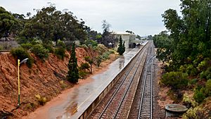
- Stirling Street: Port Augusta railway station
- off Tassie Street: Port Augusta Wharf
- 12 Tassie Street: Bank of South Australia, Port Augusta
Images for kids
See also
 In Spanish: Puerto Augusta para niños
 | Lonnie Johnson |
 | Granville Woods |
 | Lewis Howard Latimer |
 | James West |


