
Eyre Peninsula facts for kids
Quick facts for kids Eyre PeninsulaSouth Australia |
|
|---|---|

Near Lipson Cove
|
|

Eyre Peninsula
Location in South Australia
|
|
| Population | 58,700 (2011) |
| • Density | 0.3443/km2 (0.892/sq mi) |
| Area | 170,500 km2 (65,830.4 sq mi) |
| LGA(s) | See Local government areas |
| Region | Eyre Western Far North |
| State electorate(s) | Flinders Giles |
| Federal Division(s) | Grey |
| Footnotes | Population Area Coordinates |
The Eyre Peninsula is a large, triangular piece of land in South Australia. It has water on two sides: the Spencer Gulf to the east and the Great Australian Bight to the west. To the north, it is bordered by the Gawler Ranges.
This peninsula was named after Edward John Eyre. He was an explorer who traveled through parts of the area between 1839 and 1841. Before that, the coastline was first mapped by Matthew Flinders in 1801–02. A French explorer, Nicolas Baudin, also charted the coast around the same time.
The main way people make a living here is through farming. But other industries like aquaculture (raising seafood), mining, and tourism are also growing. The biggest towns are Port Lincoln in the south, Whyalla and Port Augusta in the northeast, and Ceduna in the northwest. These towns are important centers for the people living on the peninsula.
Contents
Exploring the Eyre Peninsula
The Eyre Peninsula got its name from explorer Edward John Eyre. This happened on November 7, 1839. It was named by George Gawler, who was the second Governor of South Australia.
People and Population
As of June 30, 2010, about 58,700 people lived on the Eyre Peninsula. This means about 3.6% of South Australia's total population lives here. Around 2,500 people, which is 4.4% of the population, are Indigenous people.

How People Make a Living
The economy of the Eyre Peninsula is based on several important industries. These include farming, fishing, mining, and tourism.
Farming and Fishing
Farming is the biggest industry here. In the drier northern parts, farmers grow cereal crops like wheat and barley. They also raise sheep and cattle. In the south, where there is more water, people do dairy farming and grow grapes for wine.
Many towns along the coast have commercial fishing boats. Port Lincoln has the largest fishing fleet. This town used to be famous for catching southern bluefin tuna. Now, many fishing businesses are changing to fish farming. They raise tuna and yellowtail kingfish in sea cages. Oyster farming also started in the 1980s. You can find oyster farms in bays like Coffin Bay, Franklin Harbour (near Cowell), and Smoky Bay.
Mining for Resources
_(Lower_Middleback_Iron-Formation,_Paleoproterozoic,_1.81_or_1.859-1.945_Ga;_hillslope_3_km_west_of_Iron_Duke_Mine,_South_Middleback_Range,_Eyre_Peninsula,_South_Australia)_2_(15059380105).jpg)
Since 1919, gypsum has been mined at Lake MacDonnell. This is the largest gypsum deposit in the southern hemisphere. The gypsum is then shipped from Thevenard. In 2022, over 1 million tonnes were produced each year.
Iron ore is also mined by Arrium in the Middleback Range, near Iron Knob. This is inland from Whyalla. Some of the iron ore is melted down to make steel for the Whyalla Steelworks. More and more iron ore is also being sent directly to countries in Asia.

There is also a commercial nephrite jade mine near Cowell. You can even buy jade souvenirs in the town. The peninsula has many small, old mines and quarries. It is thought to have other valuable minerals too, like graphite, coal, and uranium. Many new deposits have been found recently.
Tourism and Attractions


The Eyre Peninsula is known as the 'Seafood Frontier'. This is because of all the different types of seafood found here. Some key seafood species are southern bluefin tuna and yellowtail kingfish. These are farmed in Port Lincoln and Arno Bay. Pacific oysters are grown in places like Coffin Bay and Cowell. Other seafood includes abalone, King George whiting, and blue swimmer crabs.
The peninsula has many beautiful natural places to visit. These include three national parks and many conservation parks. You can also explore the long coastline.
Many tour operators offer ways to see the amazing marine animals up close. You can even get in the water with them.
- From Whyalla, you can snorkel or dive at Point Lowly. Here, you can see giant Australian cuttlefish gathering to breed from May to August.
- From Port Lincoln, you can swim in a cage with southern bluefin tuna. You can also swim with Australian sea lions. For a bigger thrill, you can go in a shark cage to see great white sharks near the Neptune Islands.
- Ceduna is near the Nullarbor Plain. You can take oyster farm tours at Smoky Bay. This lets you see how oysters are grown. You can also go fishing for King George whiting or blue swimmer crabs without a license.
- On the west coast, you can snorkel with Australian sea lions and bottlenose dolphins in Baird Bay. From May to October, you can watch southern right whales from the shore or a boat at Fowler's Bay.
Murphy's Haystacks are a special group of rock formations. They are located between Streaky Bay and Port Kenny.
You can learn about the peninsula's history at local museums. These include the Mount Laura Homestead Museum in Whyalla and the Koppio Smithy Museum. The Whyalla Maritime Museum shows the history of the old shipyards. It even has a World War II ship, HMAS Whyalla, on display. Fishing trips are also available from many coastal towns.
Getting Around
Roads

Major towns on the peninsula are connected by highways. The Eyre Highway (Route A1) goes across the northern part of the peninsula. The Flinders Highway (Route B100) follows the west coast. The Lincoln Highway (Route A100) follows the east coast. Both meet at Port Lincoln in the south.
The Tod Highway (Route B90) cuts through the middle of the peninsula. It runs from Port Lincoln north to the Eyre Highway. The Birdseye Highway (Route B91) also crosses the peninsula. It goes from Elliston on the west coast to the Lincoln Highway near Cowell.
Trains
The Eyre Peninsula Railway is a special train network just for the peninsula. In 1950, it was 777 kilometers long. Now, only a 60-kilometer section is still open. It is operated by Aurizon. This train network has always been separate from the main national rail system.
Sea Travel
A ferry for cars and people connects the Eyre Peninsula at Lucky Bay to the Yorke Peninsula at Wallaroo.
Water Supply
Clean drinking water is not easy to find on the peninsula. Water is pumped hundreds of kilometers from the Murray River to Whyalla through the Morgan-Whyalla pipeline. Water from underground sources is becoming saltier over time.
The Tod Reservoir was built in the 1920s to help supply water to Port Lincoln. However, it was stopped from being used in the early 2000s. This was due to concerns about increasing salt levels and pollution from farm chemicals. Water authorities are looking into building plants to remove salt from seawater. This would help ensure enough water for the future.
Protecting the Environment

Many special areas on the peninsula are protected to help nature. These include:
- Conservation Parks: Places like Acraman Creek and Kellidie Bay. These parks protect plants and animals.
- National Parks: Coffin Bay, Lincoln, and Gawler Ranges are large areas that protect important natural features and wildlife.
- Wilderness Protection Areas: Areas like Hambridge and Memory Cove are kept wild and untouched.
Past Events
The coastline of the peninsula has many old shipwrecks from the 1800s and 1900s.
In the 1920s, seven people sadly lost their lives while building the Tod Reservoir. This is north of Port Lincoln.
In January 2005, nine people were killed in a large Eyre Peninsula Bushfire.
Images for kids
-
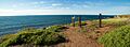
Near Lipson Cove
-
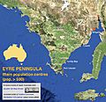
Eyre Peninsula towns and cities with a population of more than 500 (Australian census 2011)
-
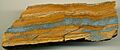
Banded iron formation, South Middleback Range, Eyre Peninsula. Orangish-brown = quartz mixed with limonite. Silvery-gray = hematite.
-
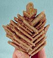
Unusual herringbone crystals of evaporite gypsum, from Sinclairs Gap Lake, Middleback Range, Eyre Peninsula. Size: 10.8 x 9.8 x 6.0 cm.
-

Cage-diving with great white sharks is possible for tourists off Eyre Peninsula.
-
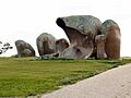
Murphy's Haystacks are a unique geological feature.
-
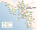
Highway map of South Australia, including highways on the Eyre Peninsula identified by their route number
-
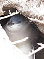
Little penguins nest in Eyre Peninsula's coastal protected areas.
-
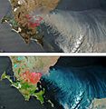
Bushfires on southern Eyre Peninsula in 2005

See also
 In Spanish: Península de Eyre para niños
