
Streaky Bay, South Australia facts for kids
Quick facts for kids Streaky BaySouth Australia |
|||||||||
|---|---|---|---|---|---|---|---|---|---|
.jpg)
Streaky Bay Jetty
|
|||||||||

Streaky Bay
Location in South Australia
|
|||||||||
| Population |
|
||||||||
| Established | 1872 | ||||||||
| Postcode(s) | 5680 | ||||||||
| Elevation | 12.2 m (40 ft) | ||||||||
| Location | 727 km (452 mi) North West of Adelaide | ||||||||
| LGA(s) | District Council of Streaky Bay | ||||||||
| State electorate(s) | Flinders | ||||||||
| Federal Division(s) | Grey | ||||||||
|
|||||||||
Streaky Bay (once called Flinders) is a town by the sea in South Australia. It's on the western side of the Eyre Peninsula. You can find it just off the Flinders Highway. It is about 303 kilometers (188 miles) north-west of Port Lincoln. By road, it's about 727 kilometers (452 miles) from Adelaide. In 2016, about 1,378 people lived in Streaky Bay.
Streaky Bay is the main town in the District Council of Streaky Bay. It's a key area for farming crops like wheat and raising sheep. The town also has strong fishing and tourism industries.
Contents
History of Streaky Bay
For thousands of years, the Wirangu people lived in the area around Streaky Bay. They were the first inhabitants of this land.
Early European Explorers
In 1627, a Dutch explorer named Pieter Nuyts was sailing in his ship, the Gulden Zeepaard. He was the first European to see this area. Later, in 1937, a special monument was built in Streaky Bay to remember this event.
In 1802, Matthew Flinders explored the coast in his ship, the Investigator. He named the area "Streaky Bay." He wrote in his log that the water was "much discoloured in Streaks." Today, we think these streaks are caused by natural oils released by certain types of seaweed in the bay.
First Land Explorations
The first Europeans to explore the land here were John Hill and Samuel Stephens. They arrived at Streaky Bay on August 15, 1839. They used a ship called the Rapid as their base.
A few weeks later, on August 25, 1839, Edward John Eyre arrived. He had traveled overland from Port Lincoln. Eyre set up a small base about 3 kilometers (1.9 miles) from where Streaky Bay town is now. This spot, called Eyre's Waterhole, is still there today. It's listed on the South Australian Heritage Register.
Town Growth and Changes
From 1854, farmers started to move into the Streaky Bay area. The town was officially named Flinders in 1872. However, people often called it Streaky Bay. So, in 1940, the name was officially changed to Streaky Bay.
Wheat farming began in the 1880s. By 1906, a lot of wheat and wool was being shipped out of Streaky Bay. At that time, a telegraph office was set up, and mail was delivered regularly from Port Lincoln.
In September 1918, a huge blue whale, more than 26 meters (85 feet) long, washed up on rocks nearby. Its skeleton is now on display at the South Australian Museum.
Geography and Natural Wonders

Streaky Bay and its surroundings have many different types of landscapes. You can find untouched native scrubland, farmland, tall cliffs, and long surf beaches.
Inland Areas
The areas further inland are mostly used for farming. However, places like the Calpatanna Waterhole Conservation Park show what the original coastal and salt lake environments were like. This park is about 30 kilometers (19 miles) south-east of Streaky Bay. It's a great place to see local wildlife.
One of the most interesting geological features in the area is Murphy's Haystacks. These are large, pink granite rocks that are incredibly old. Scientists believe they are about 1,590 million years old!
Coastal Beauty
Many tourists come to Streaky Bay to see its amazing coastline. The bay itself is calm and protected. You can find quiet beaches all along its edge. Where the coast faces the big waves of the Southern Ocean, you'll see impressive cliffs. There are also sheltered spots with large rockpools, like Smooth Pool and The Granites. The islands of the Nuyts Archipelago are located to the north-west.
The town of Streaky Bay is located at the southern end of the bay. It sits on an enclosed inlet called Blanche Port or Augusta Harbor.
Climate
Streaky Bay has a climate with very warm, dry summers and mild, wetter winters. This is known as a hot-summer mediterranean climate. Summer temperatures can change a lot because the town is between the Southern Ocean and the Outback.
The average highest temperature in January is about 29.3°C (84.7°F). In July, the average highest temperature is about 16.5°C (61.7°F). The average lowest temperature in January and February is around 16.1°C (61.0°F). In July, it drops to about 8.5°C (47.3°F).
Streaky Bay gets about 377.4 millimeters (14.86 inches) of rain each year. It has about 115 clear days and 103 cloudy days annually. The hottest temperature ever recorded was 47.2°C (117.0°F) in January 1982. The coldest was -1.7°C (29.0°F) in July 1959.
Economy and Jobs
Agriculture (farming) and fishing have always been the main ways people make a living in Streaky Bay. Today, aquaculture (farming seafood) is also a big part of the local economy.
Farming and Livestock
The local economy relies heavily on farming. Farmers grow wheat, barley, and other cereals. They also raise sheep. Because the area can be quite dry, farmers use special techniques called dryland farming to grow crops successfully. Recently, people have started trying to raise Damara sheep, Boer goats, and grow olives. These could be important for the future.
Fishing and Seafood Farming
Commercial fishing has been very important to Streaky Bay since the early 1900s. Fishermen mainly catch Snapper and King George Whiting. More recently, seafood farming has grown a lot. Farmers now raise oysters and abalone in the waters of Streaky Bay.
Tourism and Activities
Tourism is a growing part of Streaky Bay's economy. The town gets very busy during summer holidays and at Easter. Tourists love the many natural sights and fun activities.
- Fishing: One of the most popular activities is recreational fishing. Many people come to catch the famous whiting. You can fish from the beach, rocks, or a boat. There's a new boat ramp for those who want to explore the water. People often try to catch King George whiting, Snapper, and Blue Swimmer Crabs.
- Other Activities: Besides fishing, visitors can enjoy hiking, surfing, snorkelling, and scuba diving. You can even go on guided tours to explore the area.
Community Life

In 2011, Streaky Bay had a population of 1,625 people. Most residents (86%) were born in Australia. The rest were born overseas, mainly in the United Kingdom. When asked about religion, most people said "No Religion" (26.6%). The next largest groups were Catholic (22.7%) and Anglican (17.2%).
Streaky Bay has several churches. There are also many active sports clubs, including football, cricket, bowls, netball, and golf. The town also has a swimming pool. The community has good health and education services, including the Streaky Bay Hospital, a local Area School, and a public library.
Getting Around
Most people travel to and from Streaky Bay by car using the Flinders Highway. However, there are also bus services to and from Adelaide. Streaky Bay also has its own airport, the Streaky Bay Airport.
The airport is about 10 kilometers (6.2 miles) east of the town. It's open 24 hours a day and has lights that pilots can turn on themselves. You can also find flights from nearby Ceduna Airport or Port Lincoln Airport.
Images for kids
-
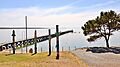
Streaky Bay Jetty
-
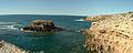
Cape Bauer, north-west of Streaky Bay
-
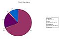
Pie chart showing religion in Streaky Bay as it was in 2001
