Flinders Highway, South Australia facts for kids
Quick facts for kids Flinders HighwaySouth Australia |
|
|---|---|
 |
|
| Highway sign, Ceduna | |
| General information | |
| Type | Highway |
| Length | 396 km (246 mi) |
| Route number(s) | (Ceduna–Hawson) |
| Former route number |
Entire route |
| Major junctions | |
| Northwest end | Ceduna, South Australia |
|
|
| Southeast end | Port Lincoln, South Australia |
| Location(s) | |
| Region | Eyre Western |
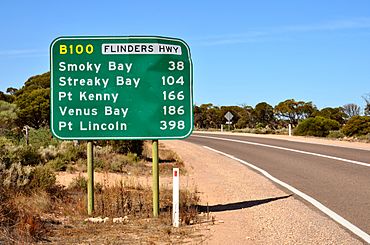
| Major settlements | Smoky Bay, Streaky Bay, Port Kenny, Elliston, Mount Hope, Coffin Bay |
| Highway system | |
| Highways in Australia National Highway • Freeways in Australia Highways in South Australia |
|
The Flinders Highway is an important road in South Australia. It connects the towns of Ceduna and Port Lincoln, covering a distance of about 396 kilometers (246 miles). This highway, along with the Lincoln Highway, offers a scenic coastal drive between Ceduna and Port Augusta. It's known as Route B100.
Exploring the Flinders Highway
The Flinders Highway follows the western coast of the Eyre Peninsula. It winds through rolling farmland, offering beautiful views. The highway is named after the famous explorer Matthew Flinders. He was the first person to explore and map this coastline in early 1802. He did this while sailing on his ship, the HMS Investigator.
Towns Along the Way
Only a few small towns are located along the Flinders Highway. Each one has something special to offer:
- Coffin Bay is a well-known place for growing delicious oysters.
- Elliston is famous for its great swimming beaches and excellent fishing spots.
- Ceduna is the biggest town on the far west coast of South Australia. It has many government offices and businesses that support the local area.
History of the Highway
The South Australian government officially named this road the "Flinders Highway" on July 1, 1938. It was decided that the road connecting Port Lincoln to Streaky Bay would carry this name.
 | Audre Lorde |
 | John Berry Meachum |
 | Ferdinand Lee Barnett |


