Neptune Islands facts for kids
| Geography | |
|---|---|
| Location | Great Australian Bight |
| Coordinates | 35°14′20″S 136°04′11″E / 35.23893°S 136.0697°E |
| Administration | |
|
Australia
|
|
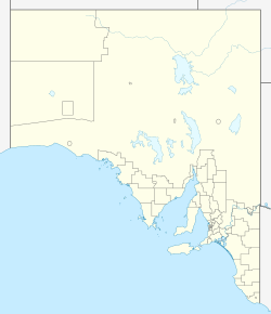
The Neptune Islands are two groups of islands located near the entrance to Spencer Gulf in South Australia. These islands are famous for being a top spot to see great white sharks up close, often through special shark cage diving tours.
Contents
What are the Neptune Islands?
The Neptune Islands are made up of two main groups: the North Neptune Islands and the South Neptune Islands. They are about 9 kilometers (5.6 miles) apart.
North Neptune Islands
The North Neptune Islands are about 27.8 kilometers (17.3 miles) south-east of the mainland at Cape Catastrophe. This group has one large island, which is about 49 meters (161 feet) tall, and a smaller islet that is 29 meters (95 feet) tall. The smaller islet is about 300 meters (980 feet) from the main island. Together, these islands cover an area of about 2.43 square kilometers (0.94 square miles).
South Neptune Islands
The South Neptune Islands are a bit further away, about 38.9 kilometers (24.2 miles) south-east from Cape Catastrophe. In this group, the islands are more similar in height. The northern island is 35 meters (115 feet) tall, and the southern island, also known as Lighthouse Island, is 37 meters (121 feet) tall. The South group covers an area of about 2.02 square kilometers (0.78 square miles).
Low Rocks
There's also a group of rocks called Low Rocks, located about 6.5 kilometers (4 miles) north-east of the North Neptune Islands.
How the Islands Were Formed
The Neptune Islands were formed a very long time ago, between 10,800 and 12,000 years ago. This happened when sea levels rose at the beginning of a period called the Holocene.
These islands are basically very old, hard rocks that have stood strong against the ocean's waves and rising sea levels. The rocks are mostly a type of granite that has been changed by heat and pressure. The seabed around the islands drops off steeply, reaching depths of 80 meters (260 feet) very close to the shore.
Plants and Animals
Even though the islands are low and exposed to strong winds and salt spray, many interesting plants and animals live there.
Plants on the Islands
Surveys have found different numbers of plant species on the islands. The North Neptune Islands have 35 types of plants. The northern island of the South group has 28 species, while Lighthouse Island has 13 species. The smaller number on Lighthouse Island is because of past activities like a lighthouse, an airstrip, and even goats that were removed in 1968. Many short-tailed shearwaters also dig burrows there, which affects plant growth.
Some of the plants you might find include Sea celery, Leek lily, flax lily, coast tussock grass, and salt couch.
Land Animals
- Mammals: The only mammals living on the islands are bush rats, found on North Neptune Island.
- Birds: You can spot birds of prey like White-bellied sea eagles, peregrine falcons, and swamp harriers. Australian kestrels are mostly on the northern island of the South group. Cape Barren geese breed on the North group, while short-tailed shearwaters, silver gulls, and greater crested terns are on the South group. Other land birds include white-fronted chats, masked plovers, rock parrots, and welcome swallows. Sparrows, which are not native to Australia, have also made a home on Lighthouse Island.
- Reptiles: Marbled geckos are found on both island groups. On the main island of the Northern group, you might see four-toed earless skinks, bull skinks, and western brown snakes. These snakes are thought to hunt the bush rats and bull skinks.
Marine Animals
The waters around the Neptune Islands are home to many marine animals.
- Seals and Sea Lions: New Zealand fur-seals and Australian sea lions are very common on all the islands. They use the islands as important breeding grounds. In the past, Australian sea lions were hunted here, but this stopped in the 1920s, and now they are a protected species.
- Great White Sharks: The large groups of seals and sea lions attract great white sharks, making the Neptune Islands a famous spot for shark tourism.
Little Penguin Colony
Little penguins used to live on the Neptune Islands. People saw them there many times between 1840 and 1934. In 1877, it was reported that the south island "swarmed with mutton-birds and penguin". However, a survey in 2006 found no penguins, and it is now believed that the penguin colony on the Neptune Islands has sadly died out.
History of the Islands
Europeans first saw the Neptune Islands on February 21, 1802. This was from the ship HMS Investigator, led by Matthew Flinders. He named them "Neptune's Isles" because they looked impossible to reach.
Later, in the 19th century, people visited the islands for "sport," hunting Australian sea-lions and other wildlife.
During World War II, the Neptune Islands became an important military spot. This was because of its lighthouse, which was key for ships entering Spencer Gulf. In November 1940, a German ship even placed a mine field about 25 kilometers (16 miles) west-south-west of the islands. A naval base with huts, observation towers, and a gun was set up on South Neptune Island.
The South Neptune Island Lighthouse Complex is now a protected heritage site in South Australia.
Lighthouses and other navigation aids have been on the Neptune Islands since the early 1900s. Because the islands are quite low, a lighthouse was needed to warn ships.
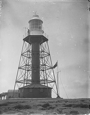
In 1901, the light tower from the Port Adelaide Lighthouse was moved to South Neptune Island. This tower was replaced in 1985 by a smaller brick tower. The old tower was then moved to Port Adelaide and is now part of the South Australian Maritime Museum. The new lighthouse became automatic in 1990, meaning the lighthouse keepers and their families no longer had to live on the island.
Another light was put on the largest island in the southern group in 1983. It was on a 12-meter (39-foot) tall tower but was removed between 2002 and 2003.
Climate
The Neptune Islands have a Mediterranean climate, which means they have mild summers and cool winters. The island only gets about 45 clear days each year. Weather information has been collected at the South Neptune Islands since 1957, first by lighthouse keepers and now by an automatic weather station.
Economic Activities
Fishing
The waters around the Neptune Islands are important for commercial fishing. People fish for abalone, marine scalefish, rock lobster, and sardines. Other sea creatures like giant crabs and octopus are also caught.
Tourism
The Neptune Islands are a very popular place for shark cage diving to see great white sharks. This activity has been happening here since the late 1970s. Since 2002, it's the only place in Australia where this is allowed by law.
This unique tourism has helped people learn a lot about sharks. Photographers and filmmakers have shared amazing pictures and videos from the Neptune Islands with people all over the world. Other tourist activities include fishing trips, watching marine mammals, and visits from cruise ships.
Protected Areas
The Neptune Islands are protected to help keep their unique wildlife safe.
Neptune Islands Conservation Park
The Neptune Islands Conservation Park covers all the islands and the waters up to 2 nautical miles (3.7 kilometers) from the shore, except for Lighthouse Island and Low Rocks. This park was created in 1967 to protect the New Zealand fur seal breeding colony, which is one of the biggest in Australia. It also protects Australian sea lions and breeding birds like Cape Barren goose, white-bellied sea eagle, and peregrine falcon. The park was expanded in 1997 to include the surrounding waters.
Neptune Islands Group (Ron and Valerie Taylor) Marine Park
The Neptune Islands Group (Ron and Valerie Taylor) Marine Park was created in 2012. It includes two separate water areas around the North and South Neptune Islands. These areas are set up to protect habitats and control access to the islands and waters. The park was named after Ron and Valerie Taylor, who are famous for their work in shark and marine conservation.
Cultural Heritage
Aboriginal Heritage
Not much is known about the Aboriginal history of the Neptune Islands. While the islands can be seen from the mainland, and might have been easier to reach long ago, Aboriginal land claims in the area did not include the islands.
Lighthouse Facilities
The old lighthouse keepers' cottages, storage buildings, stone fences, rainwater tanks, grave sites, and the foundations of the first lighthouse on South Neptune Island are all protected heritage sites.
Shipwrecks
Many ships have been wrecked near the Neptune Islands over the years:
- The Frances, a cutter boat, wrecked at South Neptune Island on August 29, 1840.
- The Venus, a cutter, wrecked at North Neptune Island on June 14, 1946.
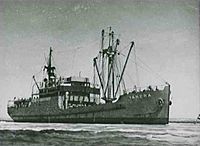
- The Yandra, a motor vessel, ran aground in thick fog on South Neptune Island on January 25, 1959.
- The Saint Michele, a fishing boat, wrecked at South Neptune Island on March 30, 1965.
- The Gloridia V, a cray-fishing boat, wrecked at North Neptune Island on March 12, 1977.
- The Cinderella, a fishing boat, wrecked at Low Rocks on May 24, 1982.
- The Gypsy Rose, a fishing boat, wrecked on South Neptune Island on January 14, 1988.
Images for kids
 | Aurelia Browder |
 | Nannie Helen Burroughs |
 | Michelle Alexander |


