
Gawler Ranges facts for kids
Quick facts for kids Gawler Ranges |
|
|---|---|

Columnar jointing in rhyolite at the "Organ Pipes" waterfall in the ranges
|
|
| Highest point | |
| Peak | Nukey Bluff |
| Elevation | 465 m (1,526 ft) |
| Geography | |
| Country | Australia |
| State | South Australia |
| Region | Eyre Peninsula |
| Range coordinates | 32°32′S 135°22′E / 32.533°S 135.367°E |
| Geology | |
| Age of rock | Proterozoic |


The Gawler Ranges are a group of rocky hills in South Australia. They are located north of the Eyre Peninsula. The Eyre Highway runs along the southern edge of these ranges.
A big part of the ranges is protected within the Gawler Ranges National Park. This park is found north of the towns of Kimba and Wudinna. The land here is also part of a special claim by Aboriginal people, called the Gawler Ranges Native Title Claim.
Contents
History of the Gawler Ranges
The Gawler Ranges were named in 1839 by an explorer named Edward John Eyre. He named them after George Gawler, who was the Governor of South Australia at the time.
This naming happened during one of Eyre's early trips. It was before his very famous journey across the Nullarbor Plain. On this same trip, Eyre also saw the Sturt desert pea for the first time. This beautiful flower is now South Australia's official floral emblem.
Another explorer, Stephen Hack, explored the ranges in 1856. A year later, in 1857, the first pastoral lease was set up. This meant people started using the land for farming, especially for sheep. More sheep stations soon followed.
The first few years were good for farmers. They even reported finding permanent freshwater lakes. By 1876, a mail service started, connecting Port Augusta to Yardea. Later, in 1903, a telegraph service to Western Australia was built through the ranges.
Environment and Nature
Geology: How the Ranges Formed
The Gawler Ranges were created by volcanoes nearly 1.5 billion years ago! But instead of tall volcanoes, the activity formed a huge area of hardened lava. The highest point in the ranges is Nukey Bluff, which is 465 meters (about 1,526 feet) above sea level.
These ranges are a small part of a much larger area called the Gawler Craton. A craton is a very old, stable part of the Earth's crust. The Gawler Craton is rich in valuable minerals. Many of these minerals have only been found recently.
You'll also see many bornhardts in the landscape. These are large, dome-shaped rock formations. They are often smooth and steep, standing out from the surrounding land.
Birds of the Ranges
The Gawler Ranges are home to about 140 different kinds of birds. Some of the birds you might see include the large emu and the powerful wedge-tailed eagle. You might also spot the colorful Major Mitchell's cockatoo or hear the sweet song of the singing honeyeater.
Mammals of the Ranges
Several larger mammals live in the Gawler Ranges. These include the southern hairy-nosed wombat, which is a burrowing animal. You might also be lucky enough to see the yellow-footed rock wallaby. This wallaby is an endangered species, meaning it is at risk of disappearing forever.
Images for kids
-
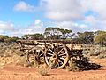
Wagon on the Mail road, near Thurlga turnoff
-
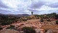
Pink granite at Hiltaba Nature Reserve


See also
 In Spanish: Cordillera Gawler para niños
