
Kimba, South Australia facts for kids
Quick facts for kids KimbaSouth Australia |
|||||||||||||||
|---|---|---|---|---|---|---|---|---|---|---|---|---|---|---|---|

Big Galah
|
|||||||||||||||

Kimba
Location in South Australia
|
|||||||||||||||
| Established | 29 April 1915 (town) 6 May 1999 (locality) |
||||||||||||||
| Postcode(s) | 5641 | ||||||||||||||
| Elevation | 280 m (919 ft)weather station | ||||||||||||||
| Time zone | ACST (UTC+9:30) | ||||||||||||||
| • Summer (DST) | ACST (UTC+10:30) | ||||||||||||||
| Location | 282 km (175 mi) north-west of Adelaide | ||||||||||||||
| LGA(s) | District Council of Kimba | ||||||||||||||
| Region | Eyre Western | ||||||||||||||
| County | Buxton | ||||||||||||||
| State electorate(s) | Giles | ||||||||||||||
| Federal Division(s) | Grey | ||||||||||||||
|
|||||||||||||||
|
|||||||||||||||
| Footnotes | Adjoining localities | ||||||||||||||
Kimba is a small town in South Australia. It is located on the Eyre Highway, which is a major road. Kimba sits at the top of the Eyre Peninsula.
A very tall statue of a galah stands next to the highway. This statue is about 8 meters (26 feet) high. It marks Kimba as the halfway point between Australia's east and west coasts. The Gawler Ranges are a group of hills found north of the town.
Kimba is part of the District Council of Kimba. It is also in the federal area called the Division of Grey and the state area called the electoral district of Giles. These are ways that Australia organizes its government.
The name "Kimba" comes from an Aboriginal word. It means "bushfire." The local council's symbol even shows a burning bush. The town was built on the traditional lands of the Barngarla people.
Contents
Kimba's Early History
The first European explorer to visit the Kimba area was Edward John Eyre. He traveled through in late 1839. He was on his way from Streaky Bay to Spencer Gulf.
How Kimba Was Settled
People first started settling here in the 1870s. These early settlers were pastoralists, who raised animals like sheep. They moved north across the Eyre Peninsula. They used the land for grazing, relying on limited water and open grassy areas.
Later, around 1908, more people came to farm wheat. There was a big demand for wheat overseas. Farmers began clearing the natural mallee scrub to grow crops. Soon, mail services started from the port town of Cowell. Wheat was carried to Cowell, which was about 76 kilometers (47 miles) away.
The Railway Arrives
In 1913, a narrow gauge railway line reached Kimba. This connected the town to Port Lincoln. The railway made it easier to transport goods. It also encouraged more wheat farmers to move to the area. Two years later, in 1915, the town of Kimba was officially created. New businesses and services then opened up.
Education in Kimba
Students in Kimba go to the Kimba Area School. This school teaches about 170 students. It covers all grades, from reception (kindergarten) to year 12 (final year of high school).
National Radioactive Waste Facility
In 2017, two properties near Kimba were suggested for a new facility. This facility would store nuclear waste. It was planned to hold low-level and intermediate-level waste.
Community Discussions
The idea caused a lot of discussion in the community. In 2017, the town held a vote. The results showed that more people supported looking into the idea further. The vote was 396 in favor and 294 against. However, some community groups were against the project. They included "No Radioactive Waste on Agricultural Land in Kimba or SA."
Project Plans and Cancellation
In 2020, the government announced a specific site. It was a property called Napandee, about 20 kilometers (12 miles) west of Kimba. The plan was to store low-level waste there permanently. Intermediate-level waste would be stored temporarily.
The government planned to spend AUD$31 million to help local businesses and workers. The facility itself was expected to cost AUD$200 million. It would create 45 jobs during building and 25 permanent jobs. However, in 2023, the project was cancelled. This happened after the Barngarla traditional owners won a court case against its construction.
Kimba's Culture and Art
Kimba is on the traditional lands of the Barngarla people. Their culture is an important part of the area's history.
Public Artworks
An 8-meter (26-foot) tall statue called "The Big Galah" greets visitors. It is a famous landmark in Kimba. The town also has an annual Kimba Art Prize. Artists from South Australia and other states enter their work. The winning art is shown at the Kimba Institute in September.
In 2017, a huge mural was painted on the town's grain silos. It is 30 meters (98 feet) high. The artist, Cam Scale, created it as part of the "silo art" projects. These projects turn large silos into giant artworks across Australia.
Kimba's Climate
Kimba has a semi-arid climate. This means it has very hot, dry summers. Winters are mild and a bit wetter.
Temperature and Rainfall
Temperatures change throughout the year. In January, the average high is about 31.6°C (89°F). In July, the average high is around 15.5°C (60°F). The lowest temperatures are in July, averaging 5.0°C (41°F).
Kimba does not get much rain. The average yearly rainfall is about 345.7 millimeters (13.6 inches). Most of the rain falls in winter. The town has many clear, sunny days each year. The hottest day recorded was 47.0°C (116.6°F) in January 2019. The coldest was -1.7°C (28.9°F) in July 1968.
| Climate data for Kimba, South Australia, Australia (33º08'24"S, 136º24'36"E, 280 m AMSL) (1967-2024 normals and extremes, rainfall to 1920) | |||||||||||||
|---|---|---|---|---|---|---|---|---|---|---|---|---|---|
| Month | Jan | Feb | Mar | Apr | May | Jun | Jul | Aug | Sep | Oct | Nov | Dec | Year |
| Record high °C (°F) | 47.0 (116.6) |
44.8 (112.6) |
42.3 (108.1) |
37.8 (100.0) |
30.0 (86.0) |
25.8 (78.4) |
27.0 (80.6) |
30.0 (86.0) |
35.5 (95.9) |
39.0 (102.2) |
43.5 (110.3) |
46.0 (114.8) |
47.0 (116.6) |
| Mean daily maximum °C (°F) | 31.6 (88.9) |
31.1 (88.0) |
28.0 (82.4) |
23.9 (75.0) |
19.4 (66.9) |
16.0 (60.8) |
15.5 (59.9) |
17.0 (62.6) |
20.4 (68.7) |
24.0 (75.2) |
27.1 (80.8) |
29.4 (84.9) |
23.6 (74.5) |
| Mean daily minimum °C (°F) | 15.8 (60.4) |
16.0 (60.8) |
14.1 (57.4) |
11.3 (52.3) |
8.4 (47.1) |
6.0 (42.8) |
5.0 (41.0) |
5.5 (41.9) |
7.1 (44.8) |
9.2 (48.6) |
11.9 (53.4) |
14.0 (57.2) |
10.4 (50.6) |
| Record low °C (°F) | 5.3 (41.5) |
7.7 (45.9) |
4.3 (39.7) |
0.6 (33.1) |
0.8 (33.4) |
−0.8 (30.6) |
−1.7 (28.9) |
−0.8 (30.6) |
−1.1 (30.0) |
0.4 (32.7) |
2.5 (36.5) |
4.6 (40.3) |
−1.7 (28.9) |
| Average precipitation mm (inches) | 19.2 (0.76) |
20.5 (0.81) |
16.6 (0.65) |
22.5 (0.89) |
34.7 (1.37) |
40.3 (1.59) |
40.6 (1.60) |
41.5 (1.63) |
36.2 (1.43) |
30.1 (1.19) |
23.4 (0.92) |
20.4 (0.80) |
345.7 (13.61) |
| Average precipitation days (≥ 0.2 mm) | 3.0 | 3.1 | 3.4 | 5.4 | 9.3 | 10.8 | 12.4 | 12.4 | 9.0 | 7.3 | 5.3 | 4.2 | 85.6 |
| Average afternoon relative humidity (%) | 28 | 31 | 33 | 38 | 49 | 57 | 55 | 50 | 42 | 34 | 30 | 30 | 40 |
| Average dew point °C (°F) | 7.6 (45.7) |
9.1 (48.4) |
7.9 (46.2) |
6.9 (44.4) |
6.9 (44.4) |
6.1 (43.0) |
5.2 (41.4) |
4.4 (39.9) |
4.5 (40.1) |
4.3 (39.7) |
5.1 (41.2) |
6.9 (44.4) |
6.2 (43.2) |
| Source: Bureau of Meteorology (1967-2024 normals and extremes, rainfall to 1920) | |||||||||||||
Farming in Kimba
Kimba is located north of Goyder's Line. This is an imaginary line in South Australia. It shows where rainfall is usually too low for farming without irrigation. Winter rainfall is very important for growing crops like wheat, barley, oats, and canola.
Farmers also raise animals, mostly merino sheep for their wool. Some cattle are also raised. Animals get their water only from rainfall. This is because there isn't much reliable groundwater in the area.
Kimba's Landscape and Soils
The Kimba area has special types of soil. Most of the soil is called calcareous earth. It contains calcrete, which is a hard layer of calcium carbonate. There are also some red-brown soils and areas with small, round iron-rich rocks.
Natural Features
To the southwest of Kimba is the Corrobinnie Depression. This area was once a river channel. Now, it is filled with deep sands. Much of this land is not good for farming. It is part of the Pinkawillinie Conservation Park.
You can find small, rounded hills in the Kelly region, east of Kimba. There are also two ranges of hills to the northeast: Botanella Hills and the Wilcherry Range. The Gawler Ranges are further north. These natural features create the boundaries of the District Council of Kimba.
Famous People from Kimba
Several notable people have come from Kimba.
Politicians from Kimba
- Arthur Whyte: He was a member and leader of the South Australian Legislative Council from 1966 to 1985.
- Barry Wakelin: He was a federal member of parliament for the Division of Grey from 1993 to 2007.
- Caroline Schaefer: She was a member of the South Australian Legislative Council from 1993 to 2010.
- Rowan Ramsey: He has been a federal member of parliament for the Division of Grey since 2007.
AFL Footballers from Kimba
- Robert Schaefer: Played 11 games for the Richmond team in 1993.
- Shane Wakelin: Played 94 games for St Kilda (1994–2000) and 158 games for Collingwood (2001–2008), for a total of 252 games.
- Darryl Wakelin: Played 115 games for St Kilda (1995–2000) and 146 games for Port Adelaide (2001–2007), for a total of 261 games.
- Corey Enright: Played 332 games for Geelong (2001–2016). He was an "All Australian" player six times and won three championships (2007, 2009, 2011).
Images for kids
-
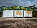
"Halfway Across Australia" sign at Kimba.
.jpg)
