
Fowlers Bay, South Australia facts for kids
Quick facts for kids Fowlers BaySouth Australia |
|||||||||||||||
|---|---|---|---|---|---|---|---|---|---|---|---|---|---|---|---|

Town of Fowlers Bay
|
|||||||||||||||

Fowlers Bay
Location in South Australia
|
|||||||||||||||
| Established | 10 July 1890 (town) 8 February 2001 (locality) |
||||||||||||||
| Postcode(s) | 5690 | ||||||||||||||
| Elevation | 3 m (10 ft) | ||||||||||||||
| Time zone | ACST (UTC+9:30) | ||||||||||||||
| • Summer (DST) | ACST (UTC+10:30) | ||||||||||||||
| Location |
|
||||||||||||||
| LGA(s) | Pastoral Unincorporated Area | ||||||||||||||
| Region | Eyre Western | ||||||||||||||
| County | Hopetoun | ||||||||||||||
| State electorate(s) | Flinders | ||||||||||||||
| Federal Division(s) | Grey | ||||||||||||||
|
|||||||||||||||
|
|||||||||||||||
| Footnotes | Locations Adjoining localities |
||||||||||||||
Fowlers Bay, once called Yalata, is a beautiful bay, town, and area in South Australia. It is located about 658 kilometers north-west of Adelaide, the state capital. The town sits on Port Eyre, which is at the western end of the larger Fowlers Bay.
The name Yalata came from the Yalata station, a large farming property started in the 1860s. This station stretched from the Nullarbor Plain to near Streaky Bay. Its main house was on a nearby hill. Today, the name Yalata refers to a small Aboriginal community further west.
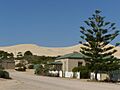
Fowlers Bay is on the Nullarbor Plain, a very flat, dry area. It used to be a busy port, a main entry point to western Australia. However, it became less important in the 1960s and 1970s. Since the 1980s, tourism has helped the town grow again. Many visitors come to see the southern right whales. These whales visit the Great Australian Bight every winter. Large sand dunes are a big feature on the southern side of the town. These dunes have been slowly moving and covering parts of the town for over a hundred years.
Contents
Exploring Fowlers Bay's Past


Aboriginal Heritage and Connections
The land where Fowlers Bay is located belongs to the traditional Wirangu people. The Mirning, Kokatha, and Maralinga Tjarutja people also have strong spiritual ties to this land. Some of them lived at the Yalata Mission in the 1950s after being moved from their homes.
The Mirning people have special dreaming stories about whales. In these stories, they call the whales from the edges of the Great Australian Bight. The word yalata comes from an Aboriginal language. It means "oyster place" or "shellfish".
Early European Discoveries
The coast around Fowlers Bay was first mapped in 1627. This was done by François Thijssen, a Dutch sea captain. His ship was called the t Gulden Zeepard'.
Later, on January 28, 1802, Matthew Flinders named the bay. He named it after his first officer, Robert Merrick Fowler. Flinders was exploring the coast in his ship, the Investigator. He confirmed the Dutch maps and named many places.
Edward John Eyre set up a base camp here in November 1840. He was on his long journeys across the Nullarbor Plain. He received supplies at a spot called Eyre's Landing. At this time, American and French whaling ships already knew the area well. Eyre saw whalers in the bay.
Whaling ships continued to visit the port in the 1800s. Whales were brought onto the beach to be processed for their oil.
How Fowlers Bay Was Settled and Named
In the 1860s, the first large farms, called pastoral leases, were started. William Swan and Robert Barr Smith created Yalata station. This huge farm stretched from the Head of the Bight in the west to Point Brown in the east. The first buildings of the station were on the beach at Port Eyre.
The station's main house, or homestead, was built in 1880. It was on a high hill about 10 kilometers inland. This large sheep station sometimes had as many as 120,000 sheep.
An unofficial post office opened in 1865. The town was first surveyed in 1867. It was officially named the "Town of Yalata" on July 10, 1890. To avoid confusion, its name was changed to Fowler's Bay on September 19, 1940. This made its name match the bay. The name Yalata now refers to a different nearby town.
Telegraph Line and Town Growth
From 1875 to 1877, parts of the East-West Telegraph Line were built. This line connected Adelaide and Perth. A supply base was set up at Fowlers Bay. This base provided equipment and food for building the line. The telegraph line became active on December 8, 1877.
Around the late 1800s, a kangaroo hunter named Tom Kent built some cottages. This small group of houses was called "Kent Town." Other hunters' families lived there. By 1892, only ruins were left. Later, sand covered all the houses.
More land was added to the town in 1910–1911. In 1990, ten more building plots were created. In 1927, the telegraph line closed. The post office shut down in 1967. These closures led to the town's decline. Some houses were left empty.
Modern Upgrades and Services
The boundaries for the Fowlers Bay area were set on February 8, 2001. The jetty (a pier for boats) was built in 1896. It was made longer in 1907, 1914, and 1948. In 2002, the jetty was upgraded. Solar lights were added in 2003.
Location, Governance, and Population
Fowlers Bay town is located on Port Eyre. This is at the western end of the larger Fowlers Bay.
The area is part of the federal Division of Grey. It is also in the state electoral district of Flinders. Fowlers Bay is in the Pastoral Unincorporated Area of South Australia. This means it does not have a local council. Instead, a state government group called the Outback Communities Authority provides services.
In the 2016 census, the areas of Fowlers Bay and Coorabie together had a population of 51 people.
What to See and Do in Fowlers Bay
Fowlers Bay does not have regular electricity or water from a central supply. Most homes use solar panels for power. Residents collect rainwater and get water from a source in the nearby sand dunes. They also manage the town's waste themselves.
The town is surrounded by large sand dunes on its southern side. These dunes have grown taller in recent years. After a very quiet time in the 1960s and 70s, Fowlers Bay has become popular. Over 8,000 visitors stay at the caravan park each year. Many more come for day trips. They often come to watch the southern right whales in the bay during winter. The old police station and courthouse from 1883 are now holiday apartments.
You can find the ruins of the old Yalata station homestead a few kilometers from town. There is also a small cemetery on the edge of town.
Important Historic Places
Fowlers Bay has one place listed on the South Australian Heritage Register. This is the Whale Bone Area and the Point Fowler Structure. There are also other old buildings that have been fixed up. These include the courthouse, the Fowlers Bay Institute, and the harbour master's house.
The Moving Sand Dunes
The large sand dunes near Fowlers Bay are moving closer to the town. By the 1970s, they had already covered the "Kent Town" houses. Only the tops of chimneys could be seen. By the 21st century, both Kent Town and the old High Street were covered. In the last ten years, the dunes have moved about 75 meters towards the new main road.
Scientists worry that climate change might be making the dunes move faster. Less rain puts stress on plants, making it harder for them to hold the sand. The CSIRO (Australia's science agency) thinks rainfall will drop by about 30 percent in this area by 2100. This will greatly affect plant life and their ability to stop the dunes.
For several years, residents have been working to stabilize the dunes. They are planting new plants like boobialla trees and other native plants. The government of South Australia has also given money to help plant more trees on the ridge that threatens the town.
Fowlers Bay's Climate
Fowlers Bay has a cool semi-arid climate. This means it's quite dry, but the Great Australian Bight helps keep temperatures from getting too extreme. Summers are usually warm to very warm and have almost no rain. However, very hot winds from inland can cause extreme heat. Winters are pleasant, often windy, and a bit damp but not very wet.
Most of the small amount of rain (about 300 mm per year) falls between May and August. The wettest year on record was 1890, with 505.8 mm of rain. The driest year was 1959, with only 89.1 mm. The highest temperature ever recorded was 48.4°C. The lowest was -3.2°C.
| Climate data for Fowlers Bay, South Australia | |||||||||||||
|---|---|---|---|---|---|---|---|---|---|---|---|---|---|
| Month | Jan | Feb | Mar | Apr | May | Jun | Jul | Aug | Sep | Oct | Nov | Dec | Year |
| Record high °C (°F) | 48.4 (119.1) |
44.1 (111.4) |
42.8 (109.0) |
40.0 (104.0) |
33.3 (91.9) |
28.3 (82.9) |
27.2 (81.0) |
30.6 (87.1) |
38.9 (102.0) |
43.3 (109.9) |
44.4 (111.9) |
46.0 (114.8) |
48.4 (119.1) |
| Mean daily maximum °C (°F) | 25.1 (77.2) |
24.1 (75.4) |
24.2 (75.6) |
22.5 (72.5) |
20.3 (68.5) |
17.8 (64.0) |
17.0 (62.6) |
18.2 (64.8) |
20.3 (68.5) |
21.8 (71.2) |
23.2 (73.8) |
24.0 (75.2) |
21.5 (70.7) |
| Mean daily minimum °C (°F) | 17.1 (62.8) |
17.0 (62.6) |
16.0 (60.8) |
13.4 (56.1) |
10.3 (50.5) |
8.1 (46.6) |
6.9 (44.4) |
7.6 (45.7) |
9.6 (49.3) |
11.8 (53.2) |
13.9 (57.0) |
15.7 (60.3) |
12.3 (54.1) |
| Record low °C (°F) | 7.2 (45.0) |
2.8 (37.0) |
5.0 (41.0) |
3.9 (39.0) |
−1.1 (30.0) |
−3.2 (26.2) |
−1.8 (28.8) |
−0.6 (30.9) |
1.7 (35.1) |
0.0 (32.0) |
3.9 (39.0) |
3.0 (37.4) |
−3.2 (26.2) |
| Average rainfall mm (inches) | 8.4 (0.33) |
12.3 (0.48) |
13.7 (0.54) |
21.6 (0.85) |
42.0 (1.65) |
51.7 (2.04) |
43.5 (1.71) |
36.1 (1.42) |
21.8 (0.86) |
20.9 (0.82) |
16.5 (0.65) |
12.0 (0.47) |
300.5 (11.82) |
| Average rainy days (≥ 0.2 mm) | 2.4 | 2.4 | 3.6 | 5.9 | 9.9 | 11.5 | 11.9 | 10.4 | 7.1 | 6.0 | 4.4 | 3.3 | 78.8 |
| Source: Bureau of Meteorology | |||||||||||||
Images for kids
-
Town of Fowlers Bay
