Yalata, South Australia facts for kids
Quick facts for kids YalataSouth Australia |
|||||||||||||||
|---|---|---|---|---|---|---|---|---|---|---|---|---|---|---|---|

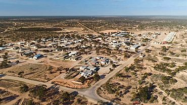
Yalata township looking north-east
|
|||||||||||||||
| Established | Mission: 1954, 1994. Locality: 23 October 2003 |
||||||||||||||
| Postcode(s) | 5690 | ||||||||||||||
| Elevation | 90 m (295 ft) | ||||||||||||||
| Area | 4563 km2 (1762 sq mi) | ||||||||||||||
| Time zone | ACST (UTC+9:30) | ||||||||||||||
| • Summer (DST) | ACDT (UTC+10:30) | ||||||||||||||
| Location |
|
||||||||||||||
| LGA(s) | Aboriginal Council of Yalata | ||||||||||||||
| Region | Eyre Western | ||||||||||||||
| County | Hopetoun (part) | ||||||||||||||
| State electorate(s) | Flinders | ||||||||||||||
| Federal Division(s) | Grey | ||||||||||||||
|
|||||||||||||||
|
|||||||||||||||
| Footnotes | Adjoining localities | ||||||||||||||
Yalata (/ˈjælətɑː/ yal-Ə-tah) is a special place in the far west of South Australia. It is both an Indigenous Protected Area and a township where an Aboriginal community lives.
The township is about 206 kilometers (128 miles) west of Ceduna, which is the closest town. It's also about 982 kilometers (610 miles) by road from Adelaide, the state capital. Yalata is located on the traditional lands of the Wirangu people.
The settlement started as the Yalata Mission in the early 1950s. This happened when Pila Nguru people were moved from the Ooldea Mission. They had been moved earlier from their lands in the Great Victoria Desert because of nuclear testing by the British Government. A nearby old sheep station called Colona is now part of the Yalata Indigenous Protected Area.
The Yalata area is described as a sandy plain with deep sand and parabolic dunes (U-shaped sand hills). The plants growing there include open mallee scrub and low open woodland.
Contents
Who Lives in Yalata?
In 2021, the Yalata Indigenous Protected Area, including the township, had 313 people. The township itself had 302 people. Most of these residents (277) were Aboriginal. The number of people living in Yalata can change, sometimes up to 500. This depends on cultural events, seasons, and other reasons.
The main language spoken in 77% of homes in the Yalata area is Pitjantjatjara, specifically a southern dialect. Many residents follow the Lutheran religion (57.2%), while others follow Australian Aboriginal traditional religions (4.5%) or Anglican (1.0%). About 11.8% said they had no religion.
A Look Back: The History of Yalata
Yalata is on the traditional lands of the Wirangu people. Many years after Europeans settled in South Australia in 1836, a large sheep station called Yalata station was set up. Its main building was built in 1880. This station was huge, stretching from the Nullarbor Plain to Point Brown, and it sometimes had as many as 120,000 sheep.
Moving People for Nuclear Tests
In the 1950s, areas near Maralinga and Emu were used for nuclear testing by the British Government. Around this time, the Australian Government took back much of the Anangu land for the Woomera Rocket testing Range.
Aboriginal people, who were Pila Nguru (Spinifex people) from the Great Victoria Desert, were moved to a mission at Ooldea. When that mission closed in 1952, these people were moved again to Yalata. This new environment was very different for them.
The Yalata Mission is Formed
In 1951, the South Australian Government bought the entire Yalata sheep station. They wanted to use it for the benefit of Aboriginal people. In 1954, most of the area became an Aboriginal reserve. The Evangelical Lutheran Church of Australia was put in charge of the Aboriginal people's spiritual well-being and education. They also managed the sheep station.
The mission included buildings for administration, a school, and a store. Residents lived in two main camps: the "Big Camp" moved around the reserve, while the "Little Camp" was for Aboriginal mission workers, their families, and some older or sick residents.
By 1969, many of the 300 people at the mission were working on the nearby Colona Station.
In 1974, the Yalata Community Council took over the reserve, and the mission stopped operating as a mission.
Land Handed Back
The Maralinga Tjarutja native title land was given back to the Anangu people in 1985. The Yalata Aboriginal lands cover about 4,580 square kilometers (1,768 square miles). In 1995, some Anangu people moved back to their land and formed a community at Oak Valley. People still travel regularly between Yalata and Oak Valley.
In 2018, the Australian Army helped Yalata by building a new staff house and a child care center. They also worked on roads and upgraded the caravan park.
How Yalata is Governed
Yalata is managed locally by the Yalata Community Council. This is one of several local government groups in South Australia known as Aboriginal Councils. The land is held in trust under the Aboriginal Lands Trust Act 1966.
For state and federal government, Yalata is part of the electoral district of Flinders and the division of Grey.
What You Can Find in Yalata
- There is a caravan park for tourists who are traveling through or visiting the Great Australian Bight for fishing or whale watching.
- The Yalata Anangu School provides education for students from Reception (kindergarten) to Year 12.
- The Yalata Mission Airport is a small airstrip that serves the community.
 | Kyle Baker |
 | Joseph Yoakum |
 | Laura Wheeler Waring |
 | Henry Ossawa Tanner |


