Nullarbor, South Australia facts for kids
Quick facts for kids NullarborSouth Australia |
|||||||||||||||
|---|---|---|---|---|---|---|---|---|---|---|---|---|---|---|---|

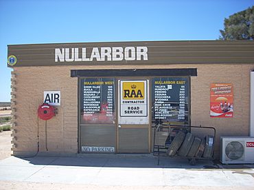
The Nullarbor Roadhouse
|
|||||||||||||||
| Established | 2013 | ||||||||||||||
| Postcode(s) | 5690 | ||||||||||||||
| Elevation | 64 m (210 ft)(weather station) | ||||||||||||||
| Time zone | ACST (UTC+9:30) | ||||||||||||||
| Location |
|
||||||||||||||
| LGA(s) | Pastoral Unincorporated Area | ||||||||||||||
| Region | Eyre Western | ||||||||||||||
| State electorate(s) | Flinders Giles |
||||||||||||||
| Federal Division(s) | Grey | ||||||||||||||
|
|||||||||||||||
|
|||||||||||||||
| Footnotes | Adjoining localities | ||||||||||||||
Nullarbor is a special place in South Australia, Australia. It is about 295 kilometers west of Ceduna. This area is right next to the border with Western Australia. Nullarbor is famous for its very flat and wide landscape.
Contents
What is Nullarbor?
The name "Nullarbor" became official on April 26, 2013. It was chosen because people had used this name for the area for a long time. The name comes from the famous Nullarbor Plain, a huge, flat area. It also refers to important protected areas like the Nullarbor Regional Reserve.
Where is Nullarbor located?
Nullarbor is bordered by the Western Australia - South Australian state border to the west. To the south, it meets the coastline of the Great Australian Bight. On its eastern side are the areas of Yalata and Yellabinna. The Trans-Australian Railway forms its northern border.
Historical Sites in Nullarbor
Nullarbor is home to two important historical sites. These are the Koonalda Cave and the Koonalda Homestead Complex. Both are listed on the South Australian Heritage Register. The Koonalda Cave is also recognized on the Australian National Heritage List. These sites show the area's long history.
Protecting the Land in Nullarbor
The entire Nullarbor area is covered by special protected areas. These areas help to look after the natural environment.
- The Nullarbor Regional Reserve is in the northern part of Nullarbor.
- The Nullarbor National Park stretches from the border.
- The Nullarbor Wilderness Protection Area is along the coast of the Great Australian Bight.
These areas are used for different purposes. People visit for tourism and to study the natural features. There is also some mineral exploration allowed in the Regional Reserve. Local Indigenous communities also use the land for cultural activities.
Traveling Through Nullarbor
The Eyre Highway is the main road that goes through Nullarbor. It connects South Australia to Western Australia. Along this highway, you'll find places that help travelers.
Services for Travelers
One settlement called "Nullarbor" is at the eastern edge of the area. Another is Border Village, right at the Western Australian border. These places offer important services for people driving through. You can find places to stay and get fuel for your car.
Nullarbor's Climate
Nullarbor has a mild semi-arid climate. This type of climate is known as BSk in the Köppen climate classification system. This means it's generally dry but not extremely hot all the time.
Extreme Temperatures
Nullarbor can get very hot. On December 19, 2019, an automatic weather station in Nullarbor recorded a temperature of 49.9 degrees Celsius (121.8 degrees Fahrenheit). This was the highest temperature recorded in Australia for that year.
| Climate data for Nullarbor, South Australia (1888–present) | |||||||||||||
|---|---|---|---|---|---|---|---|---|---|---|---|---|---|
| Month | Jan | Feb | Mar | Apr | May | Jun | Jul | Aug | Sep | Oct | Nov | Dec | Year |
| Record high °C (°F) | 48.5 (119.3) |
47.6 (117.7) |
45.3 (113.5) |
42.2 (108.0) |
36.5 (97.7) |
30.0 (86.0) |
31.2 (88.2) |
33.0 (91.4) |
38.9 (102.0) |
45.0 (113.0) |
46.6 (115.9) |
49.9 (121.8) |
49.9 (121.8) |
| Mean daily maximum °C (°F) | 28.0 (82.4) |
27.8 (82.0) |
26.7 (80.1) |
24.9 (76.8) |
21.5 (70.7) |
18.7 (65.7) |
18.3 (64.9) |
19.8 (67.6) |
22.5 (72.5) |
24.7 (76.5) |
26.0 (78.8) |
27.0 (80.6) |
23.8 (74.8) |
| Mean daily minimum °C (°F) | 16.0 (60.8) |
16.0 (60.8) |
14.3 (57.7) |
11.7 (53.1) |
9.0 (48.2) |
6.3 (43.3) |
5.2 (41.4) |
5.9 (42.6) |
7.9 (46.2) |
10.4 (50.7) |
12.5 (54.5) |
14.4 (57.9) |
10.8 (51.4) |
| Record low °C (°F) | 7.0 (44.6) |
7.0 (44.6) |
5.0 (41.0) |
2.0 (35.6) |
0.5 (32.9) |
−2.9 (26.8) |
−2.2 (28.0) |
−4.0 (24.8) |
−0.7 (30.7) |
1.0 (33.8) |
2.5 (36.5) |
2.3 (36.1) |
−4.0 (24.8) |
| Average rainfall mm (inches) | 12.2 (0.48) |
14.7 (0.58) |
20.9 (0.82) |
22.6 (0.89) |
29.8 (1.17) |
30.4 (1.20) |
27.1 (1.07) |
24.4 (0.96) |
17.7 (0.70) |
17.8 (0.70) |
17.7 (0.70) |
15.7 (0.62) |
251 (9.89) |
| Average rainy days | 1.0 | 1.1 | 1.5 | 2.1 | 3.2 | 3.2 | 3.3 | 2.8 | 2.1 | 1.7 | 1.8 | 1.5 | 25.3 |
| Source: Bureau of Meteorology | |||||||||||||
 | Stephanie Wilson |
 | Charles Bolden |
 | Ronald McNair |
 | Frederick D. Gregory |


