Flinders Ranges facts for kids
Quick facts for kids Flinders RangesSouth Australia |
|
|---|---|

Wilpena Pound from the air
|
|
| Population | 19,544 |
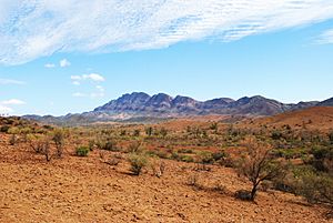
The Flinders Ranges is the biggest mountain range in South Australia. It starts about 200 km (125 mi) north of Adelaide. These mountains stretch for over 425 km (265 mi) from Port Pirie to Lake Callabonna.
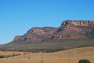
A famous landmark here is Wilpena Pound. It's a huge, natural bowl shaped like a sickle, covering 80 square kilometers (31 sq mi). Inside, you'll find St Mary Peak, the highest point in the range, which is 1,171 meters (3,842 ft) tall. This area is next to the Ikara-Flinders Ranges National Park.
The northern parts of the ranges are protected by the Arkaroola Protection Area and the Vulkathunha-Gammon Ranges National Park. In the south, you can find the fun Pichi Richi Railway and Mount Remarkable National Park. The Adnyamathanha people are the original inhabitants of this land.
Many small areas in the Flinders Ranges are protected. These include the Ikara-Flinders Ranges National Park, Mount Remarkable National Park, Arkaroola Protection Area, The Dutchmans Stern Conservation Park, and Mount Brown Conservation Park. Long walking and cycling paths like the Heysen Trail and Mawson Trail also run through the ranges, offering amazing views.
Contents
How the Flinders Ranges Were Formed
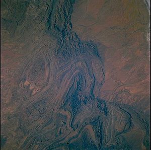
The Flinders Ranges are mostly made of old rocks that have been folded and broken. These rocks were laid down in a huge basin called the Adelaide Superbasin a very long time ago, when the ancient continent of Rodinia was forming.
Around 540 million years ago, during the Cambrian period, these rocks were pushed up and folded into a large mountain range. Over millions of years, wind and water have worn these mountains down, making them lower than they once were.
Many of the high peaks and ridges are made of hard rocks called quartzites. The tall walls of Wilpena Pound are formed by these quartzite layers, which are bent into a U-shape. Other high areas, like the Gammon Ranges and the Heysen Range, also have these folded rock structures.
The Ranges are also famous for the Ediacara Hills, located southwest of Leigh Creek. In 1946, some of the oldest animal fossils ever found were discovered here! These fossils show early animal life. In 2004, a new geological time period, the Ediacaran Period, was named after these amazing discoveries.
Climate and Weather
The Flinders Ranges has a semi-arid climate. This means it has hot, dry summers and cool winters. In summer, temperatures often go above 38°C (100°F). In winter, highs are usually around 13-16°C (55-61°F), depending on how high up you are.
Even though rain can be unpredictable, most of it falls in winter. Sometimes, there are also monsoon showers and storms from the north during summer. The area gets about 250 mm (10 in) of rain each year. Wilpena Pound gets the most, with about 350 mm (14 in).
Frost is common on winter mornings, and temperatures have dropped as low as -8°C (18°F). It has even snowed in Wilpena Pound and at Blinman! The last time there was a lot of snow was in 1995.
Plants and Animals
The plants in the Flinders Ranges are mostly types that can live in a dry environment. These include sugar gum trees, cypress-pine, mallee trees, and black oak. In wetter spots near Wilpena Pound, you can find grevilleas, Guinea flowers, and ferns. Reeds and sedges grow near places with permanent water, like springs and waterholes.
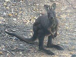
After dingos were removed and permanent waterholes were made for farm animals, the number of red kangaroos, western grey kangaroos, and wallaroos in the Flinders Ranges grew a lot. The yellow-footed rock-wallaby almost disappeared when Europeans arrived because of hunting and foxes. But now, their numbers are stable. Other small marsupials like dunnarts and planigales also live here.
Many kinds of bats that eat insects live in the ranges. There are also lots of bird species, including parrots, galahs, emus, and the wedge-tailed eagle. You might even see a few water birds. Reptiles include goannas, snakes, dragon lizards, skinks, and geckos. The streambank froglet is a special type of frog found only here.
The Ranges are part of the Tirari-Sturt stony desert area, which is a unique natural region.
History of the Flinders Ranges
The first people to live in the Flinders Ranges were the Adnyamathanha people. Their name means "hill people" or "rock people." Their descendants still live in the area today. The Ndajurri people also lived here, but they no longer exist. Cave paintings, rock carvings, and other old items show that the Adnyamathana and Ndajurri lived in the Flinders Ranges for tens of thousands of years. Evidence from the Warratyi rock shelter shows people were here about 49,000 years ago.
The first European explorers arrived in 1802. They were part of Matthew Flinders' sea trip to upper Spencer Gulf on his ship, HMS Investigator. They climbed Mount Brown in March 1802. In 1839, Edward John Eyre led another exploration party. They set out from Adelaide and explored the area, including upper Spencer Gulf.

Records show that settlers started living in the Quorn area as early as 1845. The first leases for farming land were given out in 1851. William Pinkerton is known for finding a way through the Flinders Ranges using Pichi Richi Pass. In 1853, he drove 7,000 sheep along the eastern plains to where Quorn would be built later.
In 1851, Wilpena, Arkaba, and Aroona were set up as sheep farms. Soon, other farms were started throughout the hills.
In 1852, Kanyaka Station was started by Hugh Proby.
In the late 1870s, there was a push to grow wheat north of Goyder's Line, which usually marks where farming is difficult. There was good rainfall, and crops grew well in the Flinders Ranges. Because of this, and the need to transport copper from mines, the government built a narrow-gauge railway line. It went north from Port Augusta through Pichi Richi Pass, Quorn, Hawker, and along the west of the ranges to Marree. This railway helped the farming and livestock industries.
However, the rainfall went back to normal for the region, which was not enough for farming. Many farms failed. You can still see the remains of abandoned homes in the dry landscape. Today, Wilpena is mostly a tourist spot. Some special types of wheat are still grown for export in areas around Quorn and Carrieton.
Mining continued, but only coal mining at Leigh Creek and barytes at Oraparinna were successful for a long time. The livestock industry grew, and the railway became very important for connecting and serving sheep and cattle farms along the route to Alice Springs.
The town of Hawker was surveyed in 1880. It was named after George Charles Hawker, a politician and farmer from South Australia.
Quorn was surveyed in 1878 and became a town on May 16, 1878. It covered 1.72 square kilometers (0.66 sq mi) and was laid out in squares, similar to Adelaide. Governor Jervois reportedly named it 'Quorn' because his private secretary came from a place called Quorndon in England.
|
See also
 In Spanish: Montes Flinders para niños
 | Valerie Thomas |
 | Frederick McKinley Jones |
 | George Edward Alcorn Jr. |
 | Thomas Mensah |


