
Vulkathunha-Gammon Ranges National Park facts for kids
Quick facts for kids Vulkathunha-Gammon Ranges National ParkSouth Australia |
|
|---|---|
|
IUCN Category II (National Park)
|
|

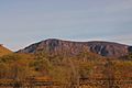
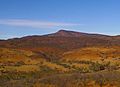
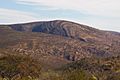
Mount McKinlay from the north
|
|

Vulkathunha-Gammon Ranges National Park
Location in South Australia
|
|
| Nearest town or city | Leigh Creek |
| Established | 1 January 1970 |
| Area | 1,257.23 km2 (485.4 sq mi) |
| Managing authorities | Department for Environment and Water |
| Website | Vulkathunha-Gammon Ranges National Park |
| See also | Protected areas of South Australia |
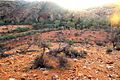
The Vulkathunha-Gammon Ranges National Park is a special protected area in the Flinders Ranges of South Australia. It's located right next to the Arkaroola Protection Area. This park is known for some of the most rugged and amazing landscapes in South Australia. It's a great place to explore nature and learn about Aboriginal culture.
Contents
Exploring the Gammon Ranges: Geography

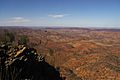
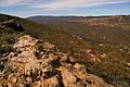
The central part of the Gammon Ranges looks different from the rest of the Flinders Ranges. Here, the rocks are mostly flat. They form a high, flat area called a plateau. Deep and amazing gorges have been carved into this plateau. This is different from the folded rocks you see further south, like at Wilpena Pound.
The Gammon Ranges are mostly covered by "The Plateau" in the southwest. This plateau is very high, just like the Blue Range to the northeast. The highest point in this area is Benbonyathe Hill, which is 1064 meters tall. Other interesting hills on the plateau include Elephant Hill, Mount Changeweather, Four Winds Hill, and Prow Point. These hills might look rounded at the top. But their sides can drop very steeply into rocky creek beds far below.

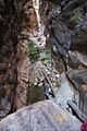
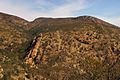
Some of the most exciting spots in the ranges are the deep gorges. These include Bunyip Chasm, The Terraces, and Fern Chasm. Many hikers enjoy visiting these areas. Cleft Peak is another popular spot. It's named for a big split that divides it into two tops. This makes it a fun challenge for rock climbers.
The high central plateau is surrounded by smaller ranges. These create areas of low hills called "pounds." For example, the Balcanoona Range surrounds Illinawortina Pound to the east. Mainwater Pound is to the north, enclosed by the Yankaninna Range. Arcoona Pound is found to the west. There are also big mountains on the edges of the Gammons. Two of them are even taller than the main range. These are Gammon Hill (1012m) in the north and Mount McKinlay (1050m) in the south.
A Journey Through Time: History of the Ranges
The Adnyamathanha people are the traditional owners of this land. Today, many live on nearby Mount Serle station and at Nepabunna. The national park is managed together with the Adnyamathanha people. This means they help make decisions about the park. A large strip of land, about 40 km wide, is also part of the park. It stretches from the ranges to Lake Frome. This area is important for the Aboriginal people for hunting kangaroos and emus.
Early Explorers
The first European to likely see these ranges was Edward John Eyre in 1840. He was exploring the western side of the Flinders Ranges. He climbed Mount Serle and saw a "high range" blocking his view to the northeast. This was the southern part of the Gammons.
Three years later, Surveyor General Edward Charles Frome explored the eastern side. He saw the highest point in the ranges and thought it was Mount Serle. But his drawings show it was actually Mount McKinlay. This mountain was named later after John McKinlay. He was famous for leading a rescue mission for the Burke and Wills expedition in 1861.

In 1857, a surveyor named J.M. Painter mapped parts of the area. His team climbed Gammon Hill and Mount McKinlay. They did not go into the very center of the ranges. You can still visit one of the survey markers they built. It's on the western edge of the ranges.
Life in the Ranges
The area has a rich history of farming and settlement. Grindell's Hut, a holiday cottage today, is named after John Grindell. He ran a small cattle farm there in the early 1900s. The famous bushman R. M. Williams also spent time here. He learned how to make boots and work with leather in Italowie Gap. His name is now on a well-known clothing brand.
The ranges were explored more fully in the first half of the 20th century. Warren Bonython led expeditions in the late 1940s. He explored The Plateau and the main central ranges. In 1946, one of his friends broke his leg on the Blue Range. Bonython had to walk over 20 kilometers to get help. His friend was carried off the mountain on a makeshift stretcher. By 1948, The Plateau had been explored in all directions. Even today, only experienced hikers can reach the highest parts of the ranges.
In the 1960s, American astronomers were interested in the high peaks. They thought Mount McKinlay and Benbonyathe Hill might be good places for an observatory. They camped on the summits and even built vehicle tracks. But no observatory was built there. You can still find old items from their camps on the mountain tops.
A historic mining site, the Bolla Bollana Brick Kiln and Copper Smelter Ruins, is inside the park. This mine only worked for three years in the 1870s. It is now a protected heritage site.
The National Park: Protecting Nature
The Gammon Ranges area was once used for farming. But much of it is so wild that only goats and hikers could get around. The northwestern part of the ranges became government land in 1968. It was declared a national park in 1970. Balcanoona station was bought in 1980 and added to the park two years later.
The national park is remote and can be hard to reach. The Copley-Arkaroola dirt road goes through Italowie Gap. This is at the southern edge of the park. From there, it's about a one-day walk north to Mount McKinlay. There's also a 4WD track into Illinawortina Pound. This leads to Grindell's Hut. From there, hikers can climb Mount John Roberts. Getting to the northern side of the park is even harder. The closest road is a 4WD track to Yankaninna station. Visitors often have to hike over the Yankaninna Range to get inside the park.
Water in the ranges is scarce and can't always be relied on. There are water tanks at Grindells Hut, Italowie Gap, and Arcoona Bluff. There are also some waterholes deep in the ranges. These are usually reliable, but they can dry up during very dry years.
Animals of the Park
The national park is south of the Dingo Fence. This means dingoes are usually not found here. Wild dogs and foxes are regularly controlled in the park. One special animal protected in the park is the yellow-footed rock wallaby.
A big challenge for the park is feral goats. These goats can easily move across the rocky land. They cause damage by hurting the ground with their hooves. They also eat a lot of plants. The park has reduced the number of goats. They use hunters at waterholes and helicopters to remove animals from ridge-tops. This has helped the plants grow back much better. Programs have also reduced the number of foxes and rabbits. Rabbit numbers have dropped a lot since a special virus was introduced.
Birds of the Park
The Gammon Ranges and Arkaroola Important Bird Area is a special place for birds. It includes the national park. This area is important because it is home to the short-tailed grasswren. It also supports populations of the pied honeyeater, chirruping wedgebill, and cinnamon quail-thrush.
What's in a Name?
No one is quite sure where the name "gammon" comes from. Some people think it might mean "hoax" because of the thick bushes in the ranges. Another idea is that "gammon" means a piece of bacon. Some say Gammon Hill can look like bacon in certain light! The Blue Range might be named because it often looks like a blue haze from far away. This is because the areas around it are so rugged.
The Aboriginal name for this area is Arkaroo. This is the name of a legendary great snake. The booming sounds sometimes heard in the ranges might be wind whistling through narrow gorges. Or, they could be large rocks falling. Arkaroo is also where the name Arkaroola comes from. This name is used for several places in the area.
Images for kids
-
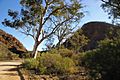
Italowie Gap
-
Cleft Peak
-
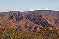
Prow Point (far right) and The Plateau (center and left)
-
Mount McTaggart
-
Loch Ness Well
-
Mount John Roberts
-
Entrance to Bunyip Chasm
-
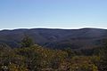
Illinawortina Pound
-
Idnina Hut (formerly Yadnina Station)
-
Benbonyathe Hill from Yadnina
-
Gammon Waterfall and Gammon Hill
-
Benbonyathe Hill and Mainwater Pound
-
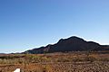
Gammon Hill
-
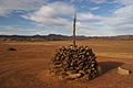
J.M. Painter's surveying cairn on western margin of ranges


.jpg)


See also
 In Spanish: Parque nacional Montes Vulkathunha-Gammon para niños
