
Heysen Trail facts for kids
Quick facts for kids Heysen Trail |
|
|---|---|
| Length | 1,200 km (750 mi) |
| Location | South Australia *Flinders Ranges *Mount Lofty Ranges *Fleurieu Peninsula |
| Established | 1978 |
| Trailheads |
|
| Use | Hiking |
| Season | sections are closed during summer |
| Waymark | |
| Sights |
|
| Surface | natural |
| Website | http://heysentrail.asn.au/ |

The Heysen Trail is a super long walking path in South Australia. It stretches for about 1,200 kilometers (745 miles)! The trail starts in the Flinders Ranges at Parachilna Gorge and goes all the way south to Cape Jervis on the Fleurieu Peninsula. It's a fantastic way to explore many different parts of South Australia on foot.
Contents
Exploring the Trail
The Heysen Trail goes through many interesting places from north to south. Some of the main spots you'll pass include Parachilna Gorge, Flinders Ranges National Park, Hawker, and Quorn. Further south, it goes through Mount Remarkable National Park, Burra, and the Adelaide Hills, before ending at Cape Jervis.
When to Walk the Trail
Because of the risk of bushfires, some big parts of the trail are closed every year. This usually happens from December to April. It's important to check if the section you want to walk is open before you go.
Walking the Trail
Most people don't walk the entire Heysen Trail all at once. Instead, they choose to walk smaller parts of it for a day or a few days. There are many places to stay along the way. If someone does decide to walk the whole trail from start to finish, it usually takes them about 60 days!
Friends of the Heysen Trail
There's a special group called the Friends of the Heysen Trail. They are volunteers who work hard to keep the trail in good shape. They also help create new walking paths and encourage people to go bushwalking as a healthy hobby. This group also organizes regular walks for people of all skill levels, from beginners to experienced hikers.
Nature Along the Trail

The Heysen Trail takes you through many different kinds of landscapes. You'll see tall cliffs, green farmlands, natural bushland, and thick forests. You'll also walk through vineyards where grapes are grown and areas where animals graze.
The trail starts near the ocean and climbs up through the fertile Mount Lofty Ranges. It then crosses an imaginary line called Goyder's Line, which marks where the land becomes much drier, leading into the arid (dry) Flinders Ranges. This means you'll experience many different natural environments, each with its own unique plants and animals.
History of the Trail
The idea for a long walking trail was first suggested by a person named Warren Bonython in 1969. However, it took several years for the plan to get started because of government discussions and issues with private landowners.
The first 50 kilometers (about 31 miles) of the trail were finally built in the Mount Lofty Ranges in 1978. This happened after the Department of Recreation and Sport took charge of the project. Terry Lavender was the main designer for the trail. He supervised most of its construction until the entire trail was finished in 1992.
The trail is named after Sir Hans Heysen, a famous Australian artist.
Images for kids
-
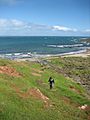
Near Victor Harbor, with Kangaroo Island visible on the left horizon.
-
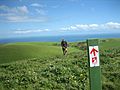
Hiking through farmland near Waitpinga.


