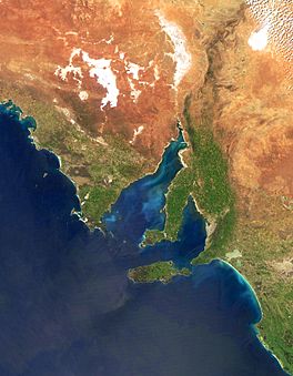
Investigator Strait facts for kids
Quick facts for kids Investigator Strait |
|
|---|---|

Investigator Strait is the body of water between Yorke Peninsula (i.e. the central land mass) and Kangaroo Island
|
|
| Lua error in Module:Location_map at line 420: attempt to index field 'wikibase' (a nil value). | |
| Location | Australia |
| Basin countries | Australia |
| Max. length | 135.3 km (84.1 mi) |
| Max. width | 48 km (30 mi) |
| Surface area | 6,100 km2 (2,400 sq mi) |
| Average depth | 34 m (112 ft) |
| Max. depth | 75 m (246 ft) |
| Islands | Althorpes Chinamans Hat Haystack Seal |
| Settlements | Marion Bay, Stenhouse Bay, Cape Jervis, Stokes Bay, Emu Bay |
The Investigator Strait is a stretch of ocean in South Australia. It lies between the Yorke Peninsula on the Australian mainland and Kangaroo Island. This strait was named by Matthew Flinders. He named it after his ship, HMS Investigator, during his journey in 1801–1802. The Gulf St Vincent is next to it, in the northeast.
Contents
Discovering Investigator Strait
The Investigator Strait got its name from Matthew Flinders. He named it on March 29, 1802.
Where is Investigator Strait?
The Investigator Strait has land on both sides. The Yorke Peninsula is to its north. Kangaroo Island is to its south.
Borders with Other Waters
The strait connects to other bodies of water. These include Gulf St Vincent and Backstairs Passage.
- The border with Gulf St Vincent runs from Troubridge Point to Cape Jervis.
- The border with Backstairs Passage goes from Cape Jervis to Kangaroo Head on Kangaroo Island.
- The border with Nepean Bay on Kangaroo Island is between Point Marsden and Kangaroo Head.
- To the west, the strait's border is from Cape Spencer to Cape Borda.
Protected Areas in the Strait
Many special areas are set up to protect nature. These areas are found within or next to the Investigator Strait.
Aquatic Reserves
- Troubridge Hill is a protected area. It is west of Troubridge Point on the Yorke Peninsula.
Marine Parks
Marine parks help protect the ocean and its creatures.
- The Southern Spencer Gulf Marine Park covers the western part of the strait. It includes parts of both the Yorke Peninsula and Kangaroo Island coasts.
- The Lower Yorke Peninsula Marine Park is at the eastern end. It is next to the south coast of the Yorke Peninsula.
- The Western Kangaroo Island Marine Park is at the western end. It is next to the north coast of Kangaroo Island.
- The Encounter Marine Park covers the eastern part of the strait. It includes its borders with Nepean Bay and Backstairs Passage.
National Parks and Other Reserves
These parks protect land and wildlife.
- On the south coast of the Yorke Peninsula, you can find:
- Innes National Park (which includes Chinamans Hat Island)
- Point Davenport Conservation Park
- On the north coast of Kangaroo Island, you can find:
- The Althorpe Islands Conservation Park is located on Althorpe Islands, Haystack Island, and Seal Island. These islands are at the northwest end of the strait.
 | Ernest Everett Just |
 | Mary Jackson |
 | Emmett Chappelle |
 | Marie Maynard Daly |

