
Dhilba Guuranda-Innes National Park facts for kids
Quick facts for kids Dhilba Guuranda-Innes National ParkInneston, South Australia |
|
|---|---|
|
IUCN Category II (National Park)
|
|

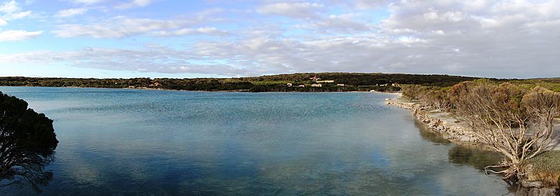
Looking west towards Cape Spencer
|
|

Dhilba Guuranda-Innes National Park
Location in South Australia
|
|
| Nearest town or city | Marion Bay |
| Established | 5 March 1970 |
| Area | 94.15 km2 (36.4 sq mi) |
| Visitation | 200,000 (in 2003) |
| Managing authorities | Department of Environment and Water |
| Website | Dhilba Guuranda-Innes National Park |
| See also | Protected areas of South Australia |
Dhilba Guuranda-Innes National Park is a special protected area in South Australia. It's located on the southwest tip of the Yorke Peninsula, about 300 kilometers (186 miles) west of Adelaide. This park is a super popular spot for outdoor fun like camping, hiking, fishing, surfing, and even scuba diving!
Contents
- Exploring Dhilba Guuranda-Innes National Park
- Animals and Plants of Innes National Park
- History of Dhilba Guuranda-Innes National Park
- The Land Before the Park
- Things to Do in Innes National Park
- Protecting the Park and Its Surroundings
- History and Culture of the Park
- Gallery
- Images for kids
- See also
Exploring Dhilba Guuranda-Innes National Park
Where is Innes National Park?

Dhilba Guuranda-Innes National Park is found at the very end of the Yorke Peninsula in South Australia. It's about a 300-kilometer (186-mile) drive from Adelaide, the state capital. The park is mostly within a town called Inneston.
What does the park cover?
The national park covers most of the land on the southwest tip of the Yorke Peninsula. It also includes four islands close to the coast: Chinamans Hat Island, Middle Island, South Island, and Royston Island. Some salty lakes, like Marion Lake, are not part of the park. These lakes were once used for mining a mineral called gypsum.
What does the park look like?

The park has a beautiful coastline with many bays and tall cliffs. Some cliffs are as high as 79 meters (259 feet)! You'll also find sandy beaches and areas with sand dunes. There are also several salty lakes inside the park.
How to get around the park
You can reach the national park by a road connected to the Yorke Highway. This road starts at Stenhouse Bay and follows the coast. It's mostly paved, but some parts are unpaved. You'll find turn-offs to cool spots like Cape Spencer, Ethel Beach, and different camping areas.
Why is it a protected area?
Dhilba Guuranda-Innes National Park is a "Category II protected area" according to the IUCN. This means it's a national park mainly set aside to protect large natural areas and the animals that live there. It's also a great place for visitors to enjoy nature.
Animals and Plants of Innes National Park
Amazing plants
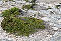
The park is home to 333 different types of native plants! Many of these are important for conservation. Four special plants found here are the annual candles, winter spider-orchid, bead samphire, and splendid bush-pea.
Wonderful wildlife

You can spot many native animals in the park.
- Mammals: Look out for New Zealand fur seals, western pygmy possums, western grey kangaroos, Australian sea lions, and short-beaked echidnas. You might even see common dolphins or bottlenose dolphins in the water, and if you're lucky, a southern right whale!
- Birds: Over 100 types of native birds live here. Some rare ones include the malleefowl, osprey, peregrine falcon, and white-bellied sea-eagle.
- Reptiles: The park has many reptiles, like the marbled gecko, painted dragon, barking gecko, and different kinds of snakes like the black tiger snake and eastern brown snake. You might also see a sleepy lizard!
Unfortunately, some animals that are not native to Australia, like cats, rabbits, and foxes, also live in the park.
History of Dhilba Guuranda-Innes National Park
The park was first created on March 5, 1970, and was called Innes National Park. It was made to protect important homes for birds like the western whipbird and the malleefowl. It also protects old buildings in Inneston. More land was added to the park over the years.
On November 14, 2020, the park was renamed Dhilba Guuranda-Innes National Park. This new name honors the Narungga people, who are the traditional owners of this land. The name change also marks a special agreement between the South Australian government and the Narungga people to manage the park together.
The Land Before the Park
The Narungga people have lived on the Yorke Peninsula for thousands of years. They had four main groups, or clans, in different parts of the peninsula.
Europeans started settling in the area in 1846, mostly for sheep farming. In the early 1900s, William Innes found a lot of gypsum here. Gypsum is a mineral used to make plaster. He started the mining town of Inneston in 1913, which grew to about 500 people. Mining stopped in 1930 because of the Great Depression. In 1970, the town and land were sold to the government, creating the national park. You can still see some of the old buildings in Inneston, and some have been fixed up for people to stay in!
Things to Do in Innes National Park
Camping
There are many great spots to camp in the park! You can find campgrounds at Stenhouse Bay, Cable Bay, Pondalowie Bay (which has three sites, including one for caravans), Shell Beach, Browns Beach, and Gym Beach.
Staying indoors
If you prefer not to camp, you can stay in some of the restored buildings at Inneston. There's also a hall at Stenhouse Bay and a cottage at Shell Beach available for rent.
Walking trails
The park has a great system of walking trails. These trails offer amazing views of the coast and ocean. You might even spot dolphins or whales! You can also see lighthouses and historic sites. Some of the main trails include:
- The Thomson Pfitzner Plaster Trail Hike (connects Stenhouse Bay and Inneston)
- The Royston Head Hike (from Dolphin Beach to Royston Head)
- The Gym Beach Hike (connects Browns Beach and Gym Beach)
There are also shorter trails to places like Cape Spencer and Ethel Beach.
Surfing
The park is famous for its surfing!
- Pondalowie Bay: This is a popular surf spot with both left and right waves. It's good for different skill levels.
- Richards Reef: A smaller right-hand wave north of Pondalowie, named after a local surfer.
- Chinamans: Near Stenhouse Bay, this is a powerful left-hand wave that breaks over rocks. It's best for experienced surfers because the water is shallow.
Protecting the Park and Its Surroundings
Marine Park
The waters around the national park, including the four islands, are part of the Southern Spencer Gulf Marine Park. This helps protect the marine life and their homes.
Important Bird Area
The park is also part of the Southern Yorke Peninsula Important Bird Area. This means it's a very important place for birds, especially the malleefowl and western whipbird.
History and Culture of the Park
Natural wonders
The park has three special lakes – Deep Lake, Inneston Lake, and Marion Lake. These lakes are home to stromatolites, which are ancient living structures made by tiny organisms. They are very important for understanding Earth's history.
Aboriginal heritage
Many sites in the park are important to the Narungga people. As of 2003, 21 such sites had been found, including burial grounds and other ancient places.
European heritage
Mining history

Two important places linked to gypsum mining are listed as heritage sites: the "Inneston Gypsum Complex" and the Stenhouse Bay Jetty.
Shipwrecks
The waters around the park are home to several historic shipwrecks. These wrecks are protected by law.
- The SS Marion ran aground in 1862 near Chinamans Hat Island.
- The Ethel crashed onto a beach (now called Ethel Beach) in 1904.
- The SS Ferret also ran aground on Ethel Beach in 1920.
- The Hougomont was sunk on purpose in 1932 near Stenhouse Bay to create a breakwater.
Gallery
-
Inneston Lake

Images for kids
-
Black snake in Innes National Park
-
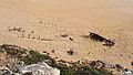
What is left of the Ethel in 2021, Ethel Beach, Dhilba Guuranda-Innes National Park


See also
 In Spanish: Parque nacional Innes para niños
