
Inneston, South Australia facts for kids
Quick facts for kids InnestonSouth Australia |
|||||||||||||||
|---|---|---|---|---|---|---|---|---|---|---|---|---|---|---|---|

Inneston Lake
|
|||||||||||||||

Inneston
Location in South Australia
|
|||||||||||||||
| Established | 1999 | ||||||||||||||
| Postcode(s) | 5577 | ||||||||||||||
| Time zone | ACST (UTC+9:30) | ||||||||||||||
| • Summer (DST) | ACST (UTC+10:30) | ||||||||||||||
| Location | 155 km (96 mi) W of Adelaide | ||||||||||||||
| LGA(s) | Yorke Peninsula Council | ||||||||||||||
| Region | Yorke and Mid North | ||||||||||||||
| County | Fergusson | ||||||||||||||
| State electorate(s) | Narungga | ||||||||||||||
| Federal Division(s) | Grey | ||||||||||||||
|
|||||||||||||||
|
|||||||||||||||
| Footnotes | Location Image caption Adjoining localities |
||||||||||||||
Inneston (once called Cape Spencer) is a special area in South Australia. It is found on the south-western tip of the Yorke Peninsula. This spot is about 155 kilometers (96 miles) west of Adelaide, the state capital.
Inneston is famous for its history of gypsum mining. Gypsum is a soft mineral used to make plaster and other building materials. Since 1970, most of Inneston has been part of a protected area. This area is now known as the Dhilba Guuranda–Innes National Park.
Contents
Exploring Inneston's Landscape
Inneston covers the entire south-western tip of the Yorke Peninsula. It stretches from Willyama Bay on the south coast to Gym Beach on the west coast.
Coastline Features
The coastline here is very interesting. From Willyama Bay to Cape Spencer, you can find several bays. These include Cable Bay and Stenhouse Bay. There are also tall pieces of land sticking out into the sea, like Rhino Head. Cliffs stand between Cable Bay and Stenhouse Bay.
From Cape Spencer to West Cape, there is a long line of cliffs. These cliffs are between 37 and 79 meters (121 and 259 feet) high. Some sandy beaches are found at the bottom of these cliffs. Further north, from West Cape to Pondalowie Bay, the cliffs are a bit lower.
From Pondalowie Bay to Gym Beach, you will mostly see sand dunes. These dunes are right next to the shore. However, there are also cliffs around Royston Head and Dolphin Beach.
Lakes and Roads
Inland from the coast, Inneston has many salty lakes. These include Inneston Lake, Marion Lake, and Spider Lake.
You can reach Inneston by road. A sealed road connects to the western end of the Yorke Highway. This road goes through Marion Bay and Stenhouse Bay. It then follows the coast, passing places like Chinamans Hat Island and Cable Bay. You will also see turn-offs to popular spots like Cape Spencer, Ethel Beach, West Cape, and Pondalowie Bay. The sealed road ends at Pondalowie Bay. From there, an unsealed (dirt) road continues to Browns Beach in the north-west.
Inneston's Past: A Look at Its History
Inneston has a rich history, especially in farming and mining.
Early Farming and Grazing
The land in Inneston was first used for farming in 1847. A man named William Burrage brought sheep to graze near Cape Spencer. By 1855, he had two leases for the land.
Water for the sheep came from wells fed by natural springs. Wells were built at Pondalowie Bay and Browns Beach in the 1850s. This helped set up sheep stations in the area by the 1860s. Farmers also tried growing crops here. However, the coastal weather and poor soil made it hard to get good harvests. After 1927, farming improved. This was because people learned about the importance of trace elements like manganese in the soil.
Gypsum Mining Operations
Mining for gypsum started in Inneston in 1889. The Australian Gypsum and Whiting Company began mining at Marion Lake. They built a railway to connect the mine to the town of Marion Bay.
In 1913, another company, Permasite, started mining gypsum at Inneston Lake. This company was from Victoria. They built a settlement on the coast that later became Stenhouse Bay. They also built a railway to connect the mine to Stenhouse Bay.
The settlement at Inneston Lake grew into a town. By the early 1900s, about 150 people lived there. The town had a public hall, a butcher, a baker, a bank, and a post office. Later, a plaster factory was built in 1916, and a chalk factory opened in 1922. By 1927, the town even had tennis courts and cricket facilities.
A jetty was built at Stenhouse Bay. This jetty was used to load gypsum onto ships. In the late 1920s or 1930s, the two mining companies joined together under one company called Waratah Gypsum Pty Ltd. Between 1905 and 1973, about 6 million tonnes (6.6 million short tons) of gypsum were taken from Marion, Inneston, and Spider Lakes. Mining continued outside the national park until just before 2003.
Establishing the National Park
In 1970, the land in Inneston was declared Innes National Park. This was done to protect important animals like the western whipbird and the mallee fowl. It also aimed to save many old buildings in Inneston. The park grew bigger in 1977, 1984, and 1993. This was because more and more people started visiting for fun.
Official Names and Boundaries
The area now known as Inneston was first called Cape Spencer. The mining town at Inneston Lake was officially named Inneston in 1927. In 1999, official boundaries were set for the area. In 2011, these boundaries were changed. A part of Inneston was moved into the nearby area of Marion Bay. This was to make sure all the houses were in Marion Bay. Inneston also includes other officially named places like Pondalowie Bay and Stenhouse Bay.
How Land is Used in Inneston Today
As of 2014, most of Inneston is part of the Innes National Park. This park is a "Coastal Conservation" area. The rest of Inneston is used for "Mineral Extraction" (mining) and "Primary Production" (farming).
Heritage-Listed Sites
Several important places in Inneston are protected by the South Australian Government. They are listed on the South Australian Heritage Register.
- Deep Lake, Inneston Lake, and Marion Lake are listed because they have stromatolites. These are ancient structures made by tiny living things.
- The Inneston Gypsum Complex and the Stenhouse Bay Jetty are also listed. These places show the history of gypsum mining in the area.
How Inneston is Governed
Inneston is part of several government areas:
- It is in the federal Division of Grey. This is how people vote for their national government representatives.
- It is in the state electoral district of Narungga. This is for voting in state elections.
- It is part of the local government area called the Yorke Peninsula Council. This council manages local services.
Images for kids
-
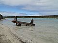
Abandoned gypsum mining equipment
-
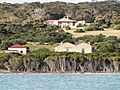
View of buildings at the abandoned mining town
-
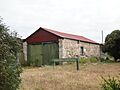
The Bellco Chalk Factory
-
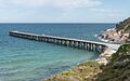
Stenhouse Bay Jetty


