Cape Spencer (South Australia) facts for kids
Quick facts for kids Cape SpencerSouth Australia |
|||||||||
|---|---|---|---|---|---|---|---|---|---|

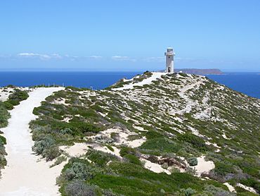
Path to Cape Spencer lighthouse, Innes National Park
|
|||||||||
| Elevation | 79 m (259 ft) | ||||||||
| LGA(s) | Yorke Peninsula Council | ||||||||
|
|||||||||
| Footnotes | Climate | ||||||||
Cape Spencer is a special piece of land that sticks out into the ocean in South Australia. You can find it at the very southwest tip of the Yorke Peninsula, near a place called Inneston.
A famous explorer named Matthew Flinders gave Cape Spencer its name in March 1802. He named it after George Spencer, 2nd Earl Spencer, who was an important person in the British Navy at the time. Since 1950, Cape Spencer has had a light to help ships find their way. It has also been part of the beautiful Innes National Park since 1970.
Contents
What is Cape Spencer Like?
Cape Spencer is about 125 kilometers (78 miles) southwest of Maitland. It is the most southwestern point of the Yorke Peninsula. When Matthew Flinders explored this area, he said Cape Spencer was the eastern edge of the entrance to Spencer Gulf.
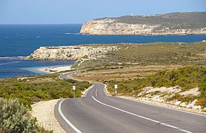
This cape is where two coastlines meet. One coastline comes from Corny Point in the north. The other comes from Troubridge Point in the east. If you look at Cape Spencer from the south, it looks like a cone with a rocky shelf at its bottom.
You can visit Cape Spencer by walking on a trail inside the Innes National Park. When you get close to the Cape Spencer Lighthouse, you can see amazing views of the coast and nearby islands. There are also signs that tell you about the area's history with ships and the sea.
How Cape Spencer Was Formed
Cape Spencer was created about 7,500 years ago. This was when the sea level rose to where it is today, at the beginning of a period called the Holocene.
The cliffs at Cape Spencer are made of different types of rock. The bottom layers are very old granite and another rock called metadolerite. On top of these, there's a layer of a softer rock called calcarenite. The water right next to the cliffs at Cape Spencer can be as deep as 14.8 meters (48.6 feet).
Who Discovered Cape Spencer?
As mentioned, Matthew Flinders named Cape Spencer on March 20, 1802. He named it after George Spencer, 2nd Earl Spencer. This Earl was one of the people in charge of the British Navy when Flinders planned his trip to explore Australia.
Later, another group of explorers from France, led by Nicolas Baudin, also explored this area. They gave the cape different names, like Pointe Mornay or Pointe des Malfaisants, which means 'Point of Evil'.
Lighthouse and Other Facilities
There has been a light to guide ships at Cape Spencer since 1950. The current lighthouse is made of concrete and was built in 1975. It replaced an older, smaller light.
Cape Spencer is also home to a special radar station. This station uses high-frequency waves to gather information about wind direction and how high the waves are in the ocean. This data is important for understanding weather and sea conditions.
Protected Area Status
Cape Spencer is a protected area. It has been part of the Innes National Park since the park was officially created in 1970. Also, the waters around Cape Spencer are part of the Southern Spencer Gulf Marine Park. This marine park helps protect the ocean animals and their homes.
 | Delilah Pierce |
 | Gordon Parks |
 | Augusta Savage |
 | Charles Ethan Porter |


