Hawker, South Australia facts for kids
Quick facts for kids HawkerSouth Australia |
|||||||||||||||
|---|---|---|---|---|---|---|---|---|---|---|---|---|---|---|---|

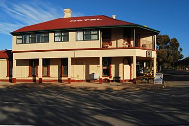
Hawker Hotel-Motel
|
|||||||||||||||
| Established | 1 July 1880 (town) 25 November 1999 (locality) |
||||||||||||||
| Postcode(s) | 5434 | ||||||||||||||
| Elevation | 315 m (1,033 ft) | ||||||||||||||
| Location | 365 km (227 mi) N of Adelaide | ||||||||||||||
| LGA(s) | Flinders Ranges Council | ||||||||||||||
| Region | Far North | ||||||||||||||
| County | Blachford Hanson |
||||||||||||||
| State electorate(s) | Stuart | ||||||||||||||
| Federal Division(s) | Grey | ||||||||||||||
|
|||||||||||||||
|
|||||||||||||||
| Footnotes | Adjoining localities | ||||||||||||||
Hawker is a small town and area in the Flinders Ranges of South Australia. It is about 365 kilometers (227 miles) north of Adelaide. The town is part of the Flinders Ranges Council. It is also in the state's Electoral district of Stuart and the federal Division of Grey.
Contents
History of Hawker
The town of Hawker was officially planned in March 1880. It was declared a town on July 1, 1880. The town was named after George Charles Hawker. He was a member of the South Australian Parliament for many years.
Hawker was once a busy railway town. This was from the 1880s until 1956. It was on the main railway line that went through Central Australia. But then the railway route changed, and Hawker became quieter.
How Hawker Got Its Name
The town of Hawker is named after George Charles Hawker. He was born in London in 1819. He came to South Australia in 1840. He started a large sheep farm called 'Bungaree Run'.
George Charles Hawker also became a politician. He was a member of parliament and even the Speaker. He helped make important decisions for the colony.
When the town was created in 1880, people were very excited. They bought land, especially near the railway station. This was a good spot for hotels and shops. The Royal Hotel, now called the Hawker Hotel, was built on one of the best spots.
In those early days, Hawker was a very lively place. People built many wooden and iron buildings. Teams of horses, bullocks, donkeys, and even camels came and went. They raised a lot of dust in the dry year of 1880.
Historic Places in Hawker
Hawker has several places that are important to its history. These are called heritage-listed sites. They include:
- 20 Cradock Road: St Philip and St James Catholic Church
- Hawker-Wilpena Road: Mount Desire Dyke
- Wonoka-Hawker Road: Hawker railway station
- 1885 Hawker Dam
Hawker's Economy
The main ways people make a living in Hawker are tourism and farming. Farmers raise sheep and more and more cattle. Because the area is dry, there aren't many animals per hectare.
Hawker is about 55 kilometers (34 miles) south of Wilpena Pound. This is a special natural area shaped like a big dish. It is very popular with tourists. The beautiful scenery of the Flinders Ranges also brings many visitors.
Tourism and Events
Every year in late May, the Hawker Racing Club holds a horse racing event. This includes the Hawker Cup. Many people from nearby areas come to watch the Thoroughbred horse races.
Hawker's Climate
Hawker has a semi-arid climate. This means it has hot summers and cool winters. It does not get much rain throughout the year. However, it usually rains a bit more in the winter months.
|
||||||||||||||||||||||||||||||||||||||||||||||||||||||||||||||||||||||||||||||||||||||||||||||||||||||||||||||||||||||||||||||
 | Sharif Bey |
 | Hale Woodruff |
 | Richmond Barthé |
 | Purvis Young |


