Kanyaka, South Australia facts for kids
Quick facts for kids KanyakaSouth Australia |
|||||||||||||||
|---|---|---|---|---|---|---|---|---|---|---|---|---|---|---|---|
 |
|||||||||||||||
| Postcode(s) | 5434 | ||||||||||||||
| Location | 32 km (20 mi) north-west of Quorn | ||||||||||||||
| LGA(s) | Flinders Ranges Council | ||||||||||||||
| State electorate(s) | Giles | ||||||||||||||
| Federal Division(s) | Grey | ||||||||||||||
|
|||||||||||||||
Kanyaka is a small rural area in the Far North region of South Australia. It is part of the Flinders Ranges Council and is known for its interesting history.
Contents
Kanyaka Station: A Big Beginning
Kanyaka is famous for Kanyaka Station, a very large sheep and cattle farm. Hugh Proby started this station in 1852. It grew to be one of the biggest farms in the area. At one point, it employed around seventy families!
In 1856, the station owner built a special eating house. This was on the main road to help visitors. It kept them from going directly to the main station buildings.
The Town of Kanyaka
A government town called Kanyaka was planned in 1863. It was surveyed, meaning its boundaries were drawn out. However, it was never officially declared a town. Even so, a two-story hotel, the Great Northern Hotel, was built there in 1865.
The Kanyaka Post Office opened on October 6, 1858. A general store also operated next to it in the 1860s. The Kanyaka township itself was not very successful. It was the smallest of four former towns in the area.
How Kanyaka Got Its Name
The area known as the Hundred of Kanyaka was officially named on July 6, 1876. This was done by Governor Anthony Musgrave. The name "Kanyaka" is believed to come from an Aboriginal name. It referred to a local waterhole.
In 1888, the District Council of Kanyaka was created. This council looked after the station area. Interestingly, its main office was outside its own boundaries, in the town of Quorn.
Kanyaka Today: A Mix of Old Towns
The modern area of Kanyaka was officially created in 1999. Its boundaries were set, and it was named after the old Kanyaka Station. This was to honor the long-standing local name.
Today's Kanyaka includes four former government towns. These were Kanyaka itself, Gordon, Simmonston, and Wilson. It also includes the farmland around them.
Towns Along Flinders Ranges Way
Three of the four former towns are located along the modern Flinders Ranges Way road.
- Kanyaka was the smallest. It was planned in 1863 but not officially declared. It was mainly just along the main road.
- Wilson was further north along the same road. It was a larger village with about eleven blocks. It was surveyed in November 1880. It was named after Charles Wilson, a "brother officer" of Governor William Jervois. Wilson had a railway station. This station was once called Palmer siding. It closed when the railway line changed its route. The old Kanyaka Post Office was renamed the Wilson Post Office in 1881.
- Gordon was located to the south, near the border with Willochra. It was another village with several blocks. Governor Jervois named it on October 2, 1879. It is said he named it after one of his brothers. Gordon also had its own railway station.
Simmonston: The Western Town
The fourth town, Simmonston, was located in the west of the Kanyaka area. It was officially recognized in 1876 but named in 1880.
Historic Places to See
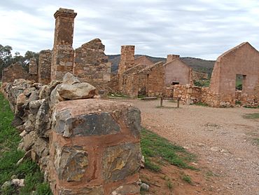
Today, you can visit the ruins of the Kanyaka Station complex (32°04′21″S 138°17′59″E / 32.0726°S 138.2997°E). These ruins include the old woolshed and a cemetery nearby. There are also stone walls on the other side of the Hawker road. All these sites are listed on the South Australian Heritage Register. This means they are important historical places.
The historic Wirreanda Creek Railway Bridge is also on the Heritage Register. It is located just off Flinders Ranges Way.
 | May Edward Chinn |
 | Rebecca Cole |
 | Alexa Canady |
 | Dorothy Lavinia Brown |


