Blinman facts for kids
Quick facts for kids BlinmanSouth Australia |
|||||||||||||||
|---|---|---|---|---|---|---|---|---|---|---|---|---|---|---|---|

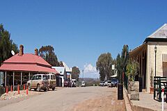
Blinman's main street
|
|||||||||||||||
| Established | 1864 (Blinman) 1867 (Blinman North) 23 October 2003 (locality) |
||||||||||||||
| Postcode(s) | 5730 | ||||||||||||||
| Elevation | 610 m (2,001 ft) | ||||||||||||||
| Time zone | ACST (UTC+9:30) | ||||||||||||||
| • Summer (DST) | ACDT (UTC) | ||||||||||||||
| Location | 425 km (264 mi) north of Adelaide | ||||||||||||||
| LGA(s) | Pastoral Unincorporated Area | ||||||||||||||
| Region | Far North | ||||||||||||||
| County | Taunton | ||||||||||||||
| State electorate(s) | Stuart | ||||||||||||||
| Federal Division(s) | Grey | ||||||||||||||
|
|||||||||||||||
|
|||||||||||||||
| Footnotes | Locations Adjoining localities |
||||||||||||||
Blinman is a small place in South Australia, located in the beautiful Flinders Ranges. It's about 425 kilometers (that's about 264 miles) north of the state capital, Adelaide. Blinman is actually made up of two old towns and is the highest surveyed town in South Australia. In 2021, only 43 people lived there. It's a hub for large farms and a popular spot for tourists. Blinman is just north of the Flinders Ranges National Park, about 60 kilometers (37 miles) north of Wilpena Pound. The town is named after Robert Blinman, a shepherd who found valuable minerals here.
The two towns were once called Blinman and Blinman North. In 1986, the original Blinman was renamed Blinman South. Blinman North then became known simply as Blinman.
Contents
History of Blinman
Blinman sits on the ancient lands of the Adnyamathanha people. They are an Aboriginal tribe who cared for this land for thousands of years. One of their traditions was using controlled fires to help new plants grow.
Early European Settlement
The first European settlement near Blinman was Angorichina Station. This sheep farm was set up in the 1850s. In December 1859, a shepherd named Robert Blinman discovered copper on the land. He believed there was more copper underground. In 1860, he received a special license to mine for minerals.
In 1861, Robert Blinman and three friends got the lease for the land that would become Blinman.
The Copper Mine's Success
The mine was very successful in its first year and became known as Wheal Blinman. The original four owners sold their mine in 1862 for a huge profit. The new owners were the Yudnamutana Copper Mining Company.
The mine did very well in the 1860s. More miners moved to the area, some from the Burra mine. Buildings were constructed, making the site permanent. A big challenge was transporting the copper ore and finding enough water. Over the next 20 years, wells were dug to provide water for the animals that pulled the ore.
In 1881, the Central Australia Railway reached Parachilna. This town is about 25 kilometers (15 miles) west of the mine. This railway made it much easier to transport the ore. Before this, the journey was 200 kilometers (124 miles) over rough dirt tracks to Port Augusta.
Life in Early Blinman
Life was tough for families in the early days. Water and firewood had to be brought from far away. Women and older children often did this job while the men worked. Many babies did not survive, and some people died from lung problems. The first tent settlement was very close to the mine. This meant it was hard to avoid the fine dust from the mining.
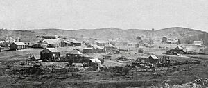
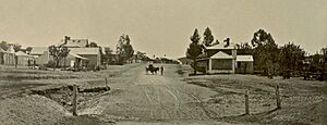
A hotel and post office opened in Blinman in 1863. In 1864, a government surveyor planned out the town. It was about 3 kilometers (1.8 miles) from the mine. By 1868, about 1500 people lived there, and the first school opened. Shops were built on the main street in 1869. That same year, miners found a regular water supply in the mine, which helped the town.
Mining continued until 1918, when the copper ore ran out. The busiest time for the mine was from 1913 to 1918. During this period, the town's population grew to about 2000 people. Around 10,000 tonnes of ore were removed from the mines in total.
How Blinman Got Its Name Changes
The area of Blinman includes two government-surveyed towns: Blinman and Blinman South. These towns are about 2 kilometers (1.2 miles) apart along the Flinders Ranges Way. The original town of Blinman was surveyed in 1864. Another town, Blinman North, was surveyed in 1867.
In 1986, the original town of Blinman was renamed Blinman South. The town that was Blinman North then became known simply as Blinman. In 2003, the Government of South Australia officially created the "locality" of Blinman. This new area included both towns within its boundaries. More land was added to the locality in 2013.
Historic Places in Blinman
Blinman has several sites that are protected for their historical importance. These include:
- Blinman Dome Diapir
- Blinman Mine and Mine Manager's Cottage
- Mine Road Dwelling and Dugout
Things to Do in Blinman
Tourists visit Blinman to experience the Outback of South Australia. They also come to see the very old rock formations in the area. The town is close to Brachina Gorge and Parachilna Gorge. These gorges rarely have flowing water. The Blinman Pools are also nearby. Blinman is a good stop on the way to Arkaroola. The old copper mine at one end of town is a very popular attraction.
Blinman itself has a pub, a general store, a church, and a cafe/gallery. There are also tennis courts, a golf course, and a cricket pitch. However, these are not used very often. You cannot buy fuel in the town.
The Cook Out Back Festival
The Cook Out Back festival is a fun campfire cooking competition. It happens every October during the long weekend for Labour Day. Teams prepare a roast using a camp oven over hot coals. More than 500 people come to the town for this event. They camp throughout the area. It's the biggest event in Blinman and brings a lot of money from tourism.
How Blinman is Governed
Blinman is part of the federal division of Grey. For state elections, it's in the electoral district of Stuart. It's also located in the Pastoral Unincorporated Area of South Australia. This means it's not part of a regular local council. Instead, a South Australian government agency called the Outback Communities Authority provides local services.
The Adnyamathanha Traditional Lands Association is the Aboriginal Regional Authority for the Blinman area.
 | Emma Amos |
 | Edward Mitchell Bannister |
 | Larry D. Alexander |
 | Ernie Barnes |


