Adelaide Superbasin facts for kids
Quick facts for kids Adelaide Superbasin |
|
|---|---|
| Adelaide Geosyncline; Adelaide Rift Complex | |

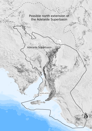
An outline of both the known and potential extent of the Adelaide Superbasin
|
|
| Coordinates | 33°41′S 138°44′E / 33.683°S 138.733°E |
| Country | |
| State(s) | South Australia; New South Wales; Victoria |
| Cities | Adelaide |
| Geology | |
| Basin type | Rift; Passive margin |
| Plate | Australian |
| Orogeny | Delamerian; Alice Springs; Spriggs |
| Age | Neoproterozoic-Cambrian |
| Stratigraphy | Stratigraphy |
| Faults | Paralana; Norwest; Anabama-Redan |
The Adelaide Superbasin is a huge area of ancient rocks in central and south-east South Australia, western New South Wales, and western Victoria. It used to be called the Adelaide Geosyncline or Adelaide Rift Complex. These rocks formed between about 1 billion and 500 million years ago, during the Neoproterozoic and Cambrian periods.
This superbasin is made of many layers of sedimentary rocks and some volcanic rocks. They were laid down when the supercontinent Rodinia was breaking apart. Scientists think these rocks are similar to ones in North America. This suggests those landmasses were once joined in Rodinia.
Cool events recorded in these rocks include two "Snowball Earth" periods. During these times, the Earth was almost completely covered in ice! You can also find evidence of a huge meteor impact (the Acraman event). Plus, the rocks show the rise of the first complex life forms, called the Ediacaran Fauna.
Contents
Where is the Adelaide Superbasin?
The Adelaide Superbasin stretches for about 850 kilometers (530 miles) from north to south. It goes from the Peake and Denison Ranges in central South Australia. It then extends through the famous Flinders Ranges and Mount Lofty Ranges. It narrows at the Fleurieu Peninsula and reaches Kangaroo Island.
From west to east, it covers about 700 kilometers (430 miles). It starts from the eastern edge of Lake Gairdner and goes to the Barrier Ranges in New South Wales. We don't fully know how far north and east it goes. This is because younger rock layers cover much of it.
Most of the rocks we can see today are in the Flinders Ranges and the Mount Lofty Ranges. These are two major mountain ranges in South Australia.
How the Adelaide Superbasin Formed
The rocks in the Adelaide Superbasin started forming around 830 million years ago. This was when the supercontinent Rodinia began to split apart. This splitting caused a huge crack, or "rift," in the Earth's crust.
Sediment continued to build up until about 514 to 490 million years ago. At this time, a major mountain-building event called the Delamerian Orogeny happened. This event folded and squashed the rocks, stopping new layers from forming.
At first, the basin formed as the land slowly sank. Later, it became a true rift basin, like a giant valley. After about 725 million years ago, it became a "passive margin." This means it was a quiet edge of a continent next to an ocean.
The rocks show that the area changed over time. It went from salty lakes to shallow seas, then to areas covered by glaciers, and finally to deeper ocean environments. The thickest parts of these rock layers are about 24,000 meters (79,000 feet) deep!
Parts of the Adelaide Superbasin
The Adelaide Superbasin is made up of eight smaller basins and sub-basins. Each has its own unique features.
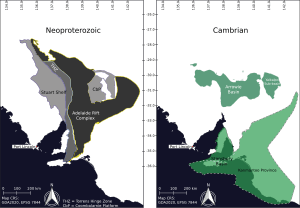
Adelaide Rift Complex
This is the oldest and most central part of the superbasin. It formed from about 840 to 550 million years ago. It has many rift valleys and quiet basin areas. A big gap in the rock layers separates it from the younger Cambrian basins.
Torrens Hinge Zone
This area is a transition zone. It lies between the flat, undisturbed rocks of the Stuart Shelf and the folded rocks of the Adelaide Rift Complex. It runs along the western edge of the main rift basin.
Stuart Shelf
The Stuart Shelf is an area where flat layers of rock were deposited. It sits on top of the Gawler Craton. Rocks here formed after the Sturtian Glaciation, when the sea level rose. These rocks are still mostly flat and undisturbed today.
Coombalarnie Platform
Like the Stuart Shelf, this is an area of flat rock layers. It sits to the north-east of the main basin, on top of the Curnamona Province. Rocks here also formed after a major sea level rise following the Sturtian Glaciation.
Stansbury Basin
This is one of two Cambrian-age basins in the superbasin. You can see its rocks in the south, from Kangaroo Island to the Mount Lofty Ranges. It extends towards Victoria, hidden under the Murray Basin. Scientists are still studying how far east it goes.
Kanmantoo Province
This part of the Stansbury Basin is a deep rift valley. It formed early in the Cambrian period. It stretches to the Glenelg River region in Victoria. Most of its rocks were heavily folded and changed by heat and pressure during the Delamerian Orogeny.
Arrowie Basin
This is the second Cambrian-age basin. It goes from the Stuart Shelf in the west, across the Flinders Ranges, into western New South Wales. It covers parts of the Curnamona Province.
Yalkalpo Sub-basin
This is the easternmost part of the Arrowie Basin. Its western edge is the Benagerie Ridge, a high point of the Curnamona Province.
Layers of Rock in the Superbasin
The rocks of the Adelaide Superbasin are divided into three main "supergroups." These are further split into many "groups," "subgroups," and over 140 "formations." This helps scientists understand the different layers and their ages.
| Geochronology | South Australia | New South Wales | ||||||
|---|---|---|---|---|---|---|---|---|
| Eon | Era | Period | Local Chronostratigraphy (historical – not in use) | Supergroup | Groups | Subgroups | Groups | Subgroups |
| Phanerozoic | Palaeozoic | Cambrian | Unconformity overlaid by Permian glacial sediments | |||||
| Mid-late | Moralana Supergroup | Lake Frome Group / Kanmantoo Group / Yorke Group | ||||||
| Early | Kanmantoo Group / Yorke Group / Kangaroo Island Group | Keynes Subgroup / Bollaparudda Subgroup | ||||||
| Normanville Group / Hawker Group / Pavy Group / Kangaroo Island Group | ||||||||
| Unconformity | ||||||||
| Proterozoic | Neoproterozoic | Ediacaran | Marinoan | Heysen Supergroup | Wilpena Group | Pound Subgroup | Farnell Group | |
| Depot Springs Subgroup | ||||||||
| Aruhna Subgroup | ||||||||
| Sandison Subgroup | ||||||||
| Unconformity | ||||||||
| Cryogenian | Umberatana Group | Yerelina Subgroup | Toorrowangee Group | Teamsters Creek Subgroup | ||||
| Upalinna Subgroup | ||||||||
| Unconformity | Euriowie Subgroup | |||||||
| Sturtian | Nepouie Subgroup | |||||||
| Unconformity | Unconformity | |||||||
| Yudnamutana Subgroup | Yancowinna Subgroup | |||||||
| Unconformity | ||||||||
| Tonian | Warrina Supergoup | Burra Group | Belair Subgroup | Unconformity | ||||
| Torrensian | Bungarider Subgroup | |||||||
| Mundallio Subgroup | ||||||||
| Emeroo Subgroup | ||||||||
| Unconformity | ||||||||
| Willouran | Callanna Group | Curdimurka Subgroup | Poolamacca Group | Wendalpa Subgroup | ||||
| Arkaroola Subgroup | Pintapah Subgroup | |||||||
| Mesoproterozoic | Unconformity underlain by metamorphosed Mesoproterozoic basement (Gawler Craton, Curnamona Province) | |||||||
Delamerian Mountain Building
The formation of new rock layers in the Adelaide Superbasin ended in the middle Cambrian period. This was when the eastern edge of Australia became a "subduction zone." This means one part of the Earth's crust began to slide under another.
This led to a huge mountain-building event called the Delamerian Orogeny. It happened between about 514 and 490 million years ago. This event caused the rocks to fold, buckle, and break. It created a major mountain range. Today, the Mount Lofty Ranges and Flinders Ranges are what's left of these ancient mountains.
Not all parts of the basin were affected. The rocks on the Stuart Shelf and Coombalarnie Platform remained flat and undisturbed. During this time, molten rock also pushed up into the existing layers. This formed granite rocks, like those found at Victor Harbor and Palmer.
Ancient Fossils Found Here
The Adelaide Superbasin is famous for its fossils of the earliest Animalia (animals). Some of the first possible sponges have been found here. But the most well-known fossils are the Ediacaran fauna.
These unique creatures were first discovered in the Ediacara Hills of South Australia in 1946. They lived at the very end of the Neoproterozoic Era. In fact, in 2004, this time period was officially named the Ediacaran Period after these important fossil finds.
Recent Geological Changes
The mountains formed during the Delamerian Orogeny are still eroding away. The land is also slowly sinking in some places. In the South Mount Lofty Ranges, this has created long, parallel cracks in the Earth. These cracks have shaped the Adelaide Plains we see today.
 | Stephanie Wilson |
 | Charles Bolden |
 | Ronald McNair |
 | Frederick D. Gregory |


