Port Pirie facts for kids
Quick facts for kids Port PirieSouth Australia |
|||||||||
|---|---|---|---|---|---|---|---|---|---|

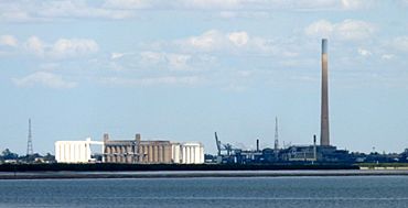
The lead smelter and grain silos at the wharf of Port Pirie
|
|||||||||
| Population | 13,896 (2021 census) | ||||||||
| Established | 1845 | ||||||||
| Postcode(s) | 5540 | ||||||||
| Elevation | 4 m (13 ft) | ||||||||
| Time zone | ACST (UTC+9:30) | ||||||||
| • Summer (DST) | ACDT (UTC+10:30) | ||||||||
| Location | 223 km (139 mi) from Adelaide | ||||||||
| LGA(s) | Port Pirie Regional Council | ||||||||
| Region | Mid North | ||||||||
| State electorate(s) | Stuart | ||||||||
| Federal Division(s) | Grey | ||||||||
|
|||||||||
Port Pirie is a city located on the east coast of the Spencer Gulf in South Australia. It is about 223 km (139 mi) north of Adelaide, the state capital. Port Pirie is the biggest city and main shopping area in the Mid North region of South Australia.
The city has a long history, dating back to 1845. Port Pirie was the first regional city in South Australia to be officially declared. Today, it is the second most important and busiest port in the state.
In 2021, the population of Port Pirie was 13,896 people. It is the eighth largest city in South Australia.
The city's economy mainly relies on one of the world's biggest lead smelters, run by Nyrstar. This smelter also produces other metals like refined silver, copper, gold, and various other products. In 2014, the smelter had a big upgrade to help reduce lead in the air. Even with these improvements, efforts continue to make sure lead levels are safe for everyone, especially children.
Contents
History of Port Pirie
Before British settlers arrived, the Nukunu people lived in the area that became Port Pirie. They called the place 'Tarparrie', which might mean "Muddy Creek".
The first European to see this area was Matthew Flinders in 1802, while he was exploring the Spencer Gulf by boat. Later, explorer Edward Eyre discovered the land. John Horrocks also found a path through the Flinders Ranges to the coast, which is now called Horrocks Pass.
The town was first named Samuel's Creek after Samuel Germein found Muddy Creek. In 1846, Governor Robe named Port Pirie Creek after the ship John Pirie. This ship was the first to sail up the creek, carrying sheep. In 1848, Matthew Smith and Emanuel Solomon bought land and planned a town called Port Pirie. However, not much happened there until the late 1860s, when only three woolsheds were on the riverfront.
The government officially surveyed the town in December 1871. Its streets were named after the family of George Goyder, who was the Surveyor General of South Australia. In 1873, Solomon and Smith's land was re-surveyed and named Solomontown. Port Pirie became a municipality on 28 September 1876, with a population of 947 people.
The discovery of rich silver, lead, and zinc ore at Broken Hill in 1883 changed the town's economy. A railway line was built from Port Pirie to Broken Hill in 1888. In 1889, a lead smelter was built to process the ore. BHP later took over and built its own smelter in 1892. By 1913, many Russians, mostly Ossetians, came to Port Pirie to work at the smelter. The town even had a Russian-language school and library.
In 1915, Broken Hill Associated Smelters (BHAS) took over the smelter. By 1934, BHAS became the largest lead smelter in the world. Over time, the smelter was owned by different companies, and since 2007, it has been run by Nyrstar.
By 1921, the town's population grew to 9,801. There were many boarding houses to house the workers for the smelter and the busy port.
During World War II (1941-1943), a Bombing and Gunnery school was set up by the Royal Air Force in Port Pirie. Sadly, 22 men died there during training.
Port Pirie was declared South Australia's first provincial city in 1953. Today, it is the second-largest port in South Australia.
Historic Buildings and Sites
Port Pirie has a nice main street and many interesting old buildings. Some of the places listed for their historical importance include:
- 1 Alexander Street: Barrier Chambers Offices
- 32 Ellen Street: Adelaide Steamship Company Building
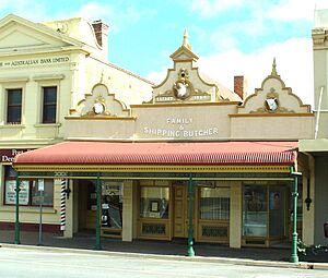
- 64-68 Ellen Street: Sampson's Butcher Shop
- 69-71 Ellen Street: Port Pirie Customs House
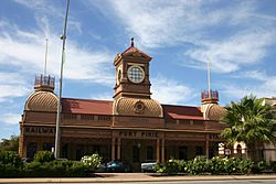
- 73-77 Ellen Street: Port Pirie (Ellen Street) railway station
- 79-81 Ellen Street: Port Pirie Post Office
- 85 Ellen Street: Development Board Building
- 94 Ellen Street: Sample Rooms, behind the Portside Tavern
- 134 Ellen Street: Family Hotel
- 32 Florence Street: Carn Brae
- 50-52 Florence Street: Waterside Workers' Federation Building
- 105 Gertrude Street: Good Samaritan Catholic Convent School
- Memorial Drive: Second World War Memorial Gates
- 5 Norman Street: AMP Society Building, Port Pirie
People of Port Pirie
In 2021, there were 13,896 people living in Port Pirie. About half of the population were female, and most were born in Australia. About 5.2% of the people were Aboriginal and/or Torres Strait Islander.
Port Pirie also has large communities of people from Italy and Greece.
The main jobs in 2021 were in metal smelting (11.0%), hospitals (6.0%), aged care (4.3%), and supermarkets (3.9%). The average weekly household income was A$1044.
Geography and Climate
Port Pirie is located 4 metres above sea level. It is about 8 kilometres (5.0 mi) inland from the Spencer Gulf, on the Pirie River. This river is a tidal saltwater inlet. The city is on the flat coastal plain, with the Spencer Gulf to the west and the Flinders Ranges mountains to the east.
Port Pirie's Climate
Port Pirie has a semi-arid climate, which means it has hot, dry summers and cool, somewhat wetter winters. The area is surrounded by mallee scrubland.
Temperatures change a lot throughout the year. The average high temperature is around 32.0 °C (89.6 °F) in January (summer) and 16.4 °C (61.5 °F) in July (winter). The average low temperature is about 17.9 °C (64.2 °F) in February and 7.7 °C (45.9 °F) in July.
Port Pirie doesn't get much rain, with an average of 345.9 mm (13.62 in) per year. Most of the rain falls in winter. The hottest temperature ever recorded was 46.3 °C (115.3 °F) in January 1979, and the coldest was −1.7 °C (28.9 °F) in June 1958.
Getting Around Port Pirie
Port Pirie is about 5 km (3 mi) off the Augusta Highway. The city also has the Port Pirie Airport, located six kilometres south of the city.
Railways
The first railway in Port Pirie opened in 1875. It connected Port Pirie to Gladstone and later to Broken Hill. The original Ellen Street station was right on the street. Today, this station is home to the Port Pirie National Trust Museum.
In 1937, Port Pirie became a place where different railway track sizes met. The wider track from Adelaide was extended to Port Pirie. At the same time, the standard-sized track from Port Augusta was extended to a new station called Port Pirie Junction.
A new station, Mary Elie Street station, was built to replace both Ellen Street and Port Pirie Junction stations. This helped move trains off Ellen Street.
When it first opened, the new station was a meeting point for different railway networks. However, over time, trains started using Coonamia station on the edge of the city more often.
Mary Elie Street station eventually closed in the 1990s. In 2009, it was turned into the city's library.
A freight line still operates into Port Pirie. It brings raw materials from Broken Hill to the metal plant and transports the finished products to Adelaide. This line is managed by Bowmans Rail.
Sea Transport
Port Pirie's port facilities are managed by Flinders Ports. About 100 ships visit each year. They carry things like mineral concentrates, refined lead and zinc, coal, grain, and other general cargo.
The Bridge to Nowhere
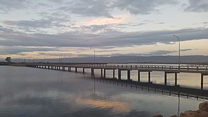
The John Pirie Bridge is often called 'the bridge to nowhere' by locals. It was built in the 1970s to encourage new industries on the other side of Port Pirie Creek. The bridge cost $410,000 to build. It was officially named the John Pirie Bridge in 1980. However, the land across the bridge has not yet been developed.
Port Pirie's Economy
The main industries in Port Pirie are the smelting of metals and the use of silos to store grain.
As of 2020, Port Pirie has the largest lead smelter and refinery in the southern hemisphere. A lead smelter has been operating here since the 1880s. Nyrstar, which has owned the smelter since 2007, is the city's main employer.
Waterfront Development
The Port Pirie Regional Council completed a big project to improve its foreshore area in 2014. This included building the Solomontown Beach Plaza, opening up Beach Road to traffic, and improving lighting and safety along the beach.
Efforts to Reduce Lead Levels
Lead smelters can cause environmental issues, including higher lead levels in the blood of some people in the town. This has been a particular concern for children growing up in the area. The state government has worked on projects to address this.
Nyrstar aims to reduce lead levels in blood. Their goal, known as the "tenby10" project, is for 95% of children aged 0 to 4 to have a blood lead level below ten micrograms per decilitre. This goal was set for the end of 2010. Lead levels in children have significantly decreased since the mid-1980s.
Studies have also found higher concentrations of lead in bottlenose dolphins that were found near the lead smelter, compared to dolphins found elsewhere in South Australia. Researchers have looked into how these metals affect dolphins' health.
Education in Port Pirie
Port Pirie has many schools and learning places:
- John Pirie Secondary School (for years 7–12)
- St Mark's College (from Foundation to year 12)
- Mid North Christian College (from reception to year 12)
- Many preschools and primary schools
- A TAFE campus for adult education.
Risdon Park High School (which used to be Port Pirie Technical High School) was a state school. In 1995, it merged with Port Pirie High School to form John Pirie Secondary School.
Culture and Arts

Port Pirie is home to the National Trust Historic and Folk Museum and Memorial Park. The Port Pirie Regional Art Gallery also serves the community.
Every September and October, the city hosts a country music festival.
The Keith Michell Theatre, located inside the Northern Festival Centre, is named after the famous actor Keith Michell. He grew up in Warnertown, which is about 5 km (3 mi) from Port Pirie.
A play called The Gods of Strangers, written by actress and playwright Elena Carapetis, is set in Port Pirie. It tells the stories of Greek, Cypriot, and Italian people who moved to regional South Australia after World War II. The play was performed in 2018 and was also filmed for online viewing.
News and Media
The main newspaper in Port Pirie is The Recorder. It was first published on March 21, 1885. Today, The Recorder is still printed on Tuesdays and Thursdays. Other local newspapers include the free The Flinders News and The Advertiser, which sometimes covers Port Pirie news.
Television channels available in Port Pirie include the ABC, SBS, and channels from Southern Cross Austereo (7, 9, and 10). Several radio stations also cover Port Pirie, such as ABC 639AM, ABC 891AM, ABC Classic FM, Radio National, ABC NewsRadio, triple j, Magic FM, and Trax FM (a community radio station).
Local Government
Port Pirie is part of the federal division of Grey. This area has been represented by Liberal MP Rowan Ramsey since 2007.
The city is also part of the state electoral district of Frome. In 2009, Port Pirie mayor Geoff Brock ran as an independent candidate and won the seat.
While the region around Port Pirie often votes for the Liberal Party because of its farming areas, Port Pirie itself is an industrial city. This means it often supports the Australian Labor Party.
Notable People from Port Pirie
Sportspeople
- Brodie Atkinson (born 1972), football player for St. Kilda and Adelaide Crows.
- Mark Bickley (born 1969), captain of the Adelaide Crows, winning two premierships.
- Abby Bishop (born 1989), basketball player for Canberra Capitals.
- Mark Jamar (born 1982), football player for Melbourne Demons.
- Lewis Johnston (born 1991), football player for Sydney Swans and Adelaide Crows.
- Sam Mayes (born 1994), football player for Brisbane Lions and Port Adelaide FC.
- Nip Pellew (1893–1981), Australian test cricketer.
- David Tiller (born 1958), captain and premiership player for North Adelaide Roosters.
- Elijah Ware (born 1983), football player for Port Adelaide and Central Districts.
Other Notable People
- Geoff Brock, state politician.
- Sir Hugh Cairns (1896–1952), a famous neurosurgeon.
- Ted Connelly, state politician.
- Lillian Crombie (1958–2024), actress.
- Andrew Lacey (1887–1946), federal and state politician, and leader of the ALP in South Australia.
- Keith Michell (1928–2015), actor.
- John Noble (born 1948), actor and director.
- Robert Stigwood (1934–2016), music entrepreneur.


