Mallee Woodlands and Shrublands facts for kids
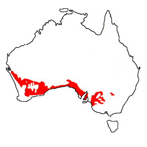
Mallee Woodlands and Shrublands are special types of plant communities found in Australia. They are one of 32 main groups of plants defined by the Australian Government.
Contents
What are Mallee Woodlands?
The word "Mallee" comes from an Aboriginal language. It describes a type of eucalypt tree that grows in a unique way. Mallee eucalypts are usually 2 to 9 meters (about 6 to 30 feet) tall. They have many stems that grow from a special woody base called a lignotuber. Their leaves create a canopy that shades a good part of the ground.
"Mallee" also describes the areas where these eucalypts grow. These areas are usually flat, without big hills or very tall trees.
What Makes Mallee Special?
Mallee Woodlands and Shrublands are known for a few key things:
- They are found in semi-arid areas, meaning they don't get a lot of rain.
- They are mostly covered by mallee eucalypts.
- Other plants like Callitris, Melaleuca, Acacia, and Hakea can also grow there.
- These areas have an open layer of trees or shrubs. More than 10% of the ground is covered by leaves.
- The plants growing under the trees depend a lot on how much rain falls. They also depend on the soil type and how often fires happen.
- Mallee areas are among the most likely places to have bushfires in dry regions.
Different Kinds of Mallee Undergrowth
The plants that grow under the main mallee trees can be different. These groups are based on the types of perennial plants (plants that live for more than two years) found there:
- Mallee with hummock grass, like Triodia scariosa and Triodia irritans.
- Mallee with a dense, bushy undergrowth.
- Mallee with an open, bushy undergrowth.
- Mallee with tussock grass undergrowth, like Themeda, Poa, and Astrebla species.
Mallee woodlands and shrublands are found in 39 different natural regions across Australia.

How Mallee Areas Have Changed
Before the year 1750, Mallee Woodlands and Shrublands covered about 318,000 square kilometers (about 122,780 square miles). Today, this area has shrunk. It is now estimated to be about 214,000 square kilometers (about 82,625 square miles). This means that in 2001, only about 65% of the original area was left.
The largest area of Mallee today is found in the Great Victoria Desert. However, before 1750, the biggest area was in the Murray-Darling basin.
About one-third of the total clearing of this plant type has happened. This clearing made up 10% of all land clearing in Australia. In South Australia, people started clearing the mallee around 1900. This happened after a new tool called the stump-jump plough was introduced.
 | Bayard Rustin |
 | Jeannette Carter |
 | Jeremiah A. Brown |


