Port Augusta West, South Australia facts for kids
Quick facts for kids Port Augusta WestPort Augusta, South Australia |
|||||||||||||||
|---|---|---|---|---|---|---|---|---|---|---|---|---|---|---|---|

Australian Arid Lands Botanic Garden
|
|||||||||||||||
| Established | 1865 | ||||||||||||||
| Postcode(s) | 5700 | ||||||||||||||
| Elevation | 14 m (46 ft) | ||||||||||||||
| Time zone | ACST (UTC+9:30) | ||||||||||||||
| • Summer (DST) | ACST (UTC+10:30) | ||||||||||||||
| Location |
|
||||||||||||||
| LGA(s) | City of Port Augusta | ||||||||||||||
| Region | Far North | ||||||||||||||
| State electorate(s) | Stuart | ||||||||||||||
| Federal Division(s) | Grey | ||||||||||||||
|
|||||||||||||||
|
|||||||||||||||
| Footnotes | Adjoining localities | ||||||||||||||
Port Augusta West is a suburb of Port Augusta in South Australia. It's a unique part of the city because it sits on the Eyre Peninsula, while the main part of Port Augusta is on the other side of the Spencer Gulf.
For a long time, Port Augusta West had its own history, separate from the rest of Port Augusta. People used a special boat called a punt to cross the water. But in 1926, a bridge was finally built, connecting the two sides. This made it much easier for people to travel between them.
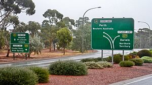
Port Augusta West was even its own town for a while! It was officially called the Corporate Town of Port Augusta West in 1887. However, it later joined up with the City of Port Augusta in 1932. Today, Port Augusta West is a very important place for travel. It's where three major highways meet: the Eyre Highway (which goes to Western Australia), the Stuart Highway (heading north to the Northern Territory), and the Augusta Highway (leading to Adelaide).
Contents
Exploring Port Augusta West: Location and Land Use
Port Augusta West is the only part of the city located on the western side of the Spencer Gulf, on the Eyre Peninsula. It's about 2 kilometers west of central Port Augusta and around 280 kilometers north of Adelaide city centre.
What You'll Find Here
This suburb has a mix of areas. Most of the homes are on the eastern side. As you move west, between the Eyre Highway and the Stuart Highway, you'll find areas used for businesses and factories. The Whyalla-Port Augusta railway line also runs along the northern and western edges of the suburb.
Parks and Landmarks
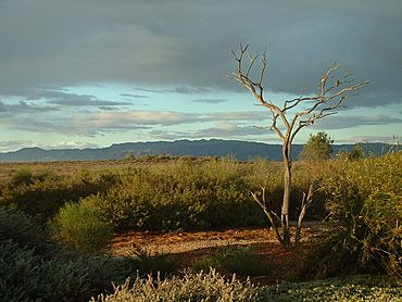
Port Augusta West is home to several interesting places. You can visit the Port Augusta Golf Club or the Port Augusta West Primary School. It also features the amazing Australian Arid Lands Botanic Garden, where you can see plants from dry areas. Other spots include the West Side Foreshore, Westside Lookout Tower, Rotary Park, Northey Crescent, and Sid Welk Park. The historic Port Augusta West Water Tower is also a special landmark here.
Port Augusta Airport
The Port Augusta Airport is located at the southern end of the suburb. It's separated from the homes by open spaces and a "vegetation buffer," which is like a natural screen of plants.
How Port Augusta West is Governed
Understanding how a place is governed means knowing who makes the rules and decisions. Port Augusta West is part of a few different government areas:
- It's in the federal division of Grey, which is how people vote for their representatives in the national government.
- For state government, it's in the electoral district of Stuart.
- Locally, it's managed by the City of Port Augusta, which is the local council.
- It's also part of the South Australian Government's Far North region.
This means that different levels of government work together to manage services and make decisions for the people living in Port Augusta West.
Climate in Port Augusta West
Port Augusta West has a warm desert climate. This type of climate is known for being very dry and hot. It's classified as a BWk climate using the Köppen climate classification system. This means it has hot summers and mild winters, with very little rainfall throughout the year.
| Climate data for Port Augusta Airport, Port Augusta West | |||||||||||||
|---|---|---|---|---|---|---|---|---|---|---|---|---|---|
| Month | Jan | Feb | Mar | Apr | May | Jun | Jul | Aug | Sep | Oct | Nov | Dec | Year |
| Mean daily maximum °C (°F) | 34.3 (93.7) |
33.3 (91.9) |
30.3 (86.5) |
26.6 (79.9) |
21.7 (71.1) |
18 (64) |
17.7 (63.9) |
20.1 (68.2) |
24.1 (75.4) |
26.9 (80.4) |
30.4 (86.7) |
31.9 (89.4) |
26.3 (79.3) |
| Mean daily minimum °C (°F) | 19.4 (66.9) |
18.9 (66.0) |
16.4 (61.5) |
12.9 (55.2) |
8.8 (47.8) |
6.2 (43.2) |
4.7 (40.5) |
5.3 (41.5) |
8.5 (47.3) |
11.5 (52.7) |
15.6 (60.1) |
17 (63) |
12 (54) |
| Average precipitation mm (inches) | 12.4 (0.49) |
18.4 (0.72) |
17 (0.7) |
18.9 (0.74) |
15.4 (0.61) |
24.7 (0.97) |
18.2 (0.72) |
14.6 (0.57) |
17.4 (0.69) |
16.5 (0.65) |
20.6 (0.81) |
23.9 (0.94) |
217.6 (8.57) |
| Source: Bureau of Meteorology | |||||||||||||
 | Kyle Baker |
 | Joseph Yoakum |
 | Laura Wheeler Waring |
 | Henry Ossawa Tanner |


