
Innamincka, South Australia facts for kids
Quick facts for kids InnaminckaSouth Australia |
|||||||||||||||
|---|---|---|---|---|---|---|---|---|---|---|---|---|---|---|---|

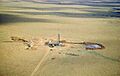
Innamincka township from the north-east;
Cooper Creek is in the foreground and left distance |
|||||||||||||||

Innamincka
Location in South Australia
|
|||||||||||||||
| Established | 17 April 1890 (town) 23 October 2003 (locality) |
||||||||||||||
| Postcode(s) | 5731 | ||||||||||||||
| Elevation | 57 m (187 ft) | ||||||||||||||
| Time zone | ACST (UTC+9:30) | ||||||||||||||
| • Summer (DST) | ACDT (UTC+10:30) | ||||||||||||||
| Location | 821 km (510 mi) NE of Adelaide | ||||||||||||||
| LGA(s) | Pastoral Unincorporated Area | ||||||||||||||
| Region | Far North | ||||||||||||||
| State electorate(s) | Stuart | ||||||||||||||
| Federal Division(s) | Grey | ||||||||||||||
|
|||||||||||||||
|
|||||||||||||||
| Footnotes | Adjoining localities | ||||||||||||||


Innamincka is a small town and area in the far north-east of South Australia. It's about 820 kilometers (510 miles) north-east of Adelaide, the state capital. The closest town, Lyndhurst, is 365 kilometers (227 miles) away.
Innamincka is located within the Innamincka Regional Reserve. It is surrounded by two large deserts: the Strzelecki Desert to the south and the Sturt Stony Desert to the north. The town sits right along the Cooper Creek, which is part of the huge Lake Eyre basin.
Contents
A Journey Through Innamincka's Past
First People and Their Land
Aboriginal Australians have lived in the Innamincka area for thousands of years. This land is known as Wangkangurru country. It is the traditional home of the Yawarrawarrka and Yandruwandha people. Their languages, like Yawarrawarrka and Wangkangurru, have been spoken here for a very long time.
Early European Explorers Arrive
The first European explorer to visit this region was Charles Sturt in 1845. Later, A. C. Gregory came through in 1858. The famous Burke and Wills expedition also passed through Innamincka. A monument was put up in 1944 to remember Sturt and Burke and Wills.
How the Town Began
In 1882, a police camp was set up in the area. This was the start of a small settlement. By 1889, a mail coach service began, bringing mail every two weeks from Farina.
The town was first named Hopetoun and officially started on April 17, 1890. It was named after the Governor of Victoria. However, local people didn't like the name. So, on January 28, 1892, it was renamed the Town of Innamincka.
Life in the Early Town
Innamincka was never a very big town. It had a hotel, a general store, and a police station. Before Australia became a country in 1901, the police station also acted as a "customs post." This meant they collected taxes on cattle that were brought from Queensland into South Australia.
In 1928, the Australian Inland Mission built a hospital called the Elizabeth Symon Nursing Home. This mission was part of the Royal Flying Doctor Service of Australia.
Challenges and Rebirth
Later, a severe drought hit the area. It became very difficult to reach the settlement. Because of this, the hotel and hospital had to close. In 1951, the police post also closed, and the town became empty.
However, things changed in the late 1960s. More tourists started visiting, and gas and oil were discovered nearby. This led to a company opening a new hotel, a store, and places for people to stay in the old town.
In 1994, the Elizabeth Symon Nursing Home was fixed up by a famous businessman named Dick Smith and the Australian Geographic magazine. Today, it's used as a visitor center for the National Parks and Wildlife Service South Australia. The nursing home is an important historical building.
The Burke and Wills Expedition
A Famous Journey and Its End
The Burke and Wills expedition was a very important journey across Australia. They traveled from Melbourne to the Gulf of Carpentaria. During their trip, they set up a main camp at The Dig Tree on Cooper Creek. They stayed at this camp from December 1860 to April 1861.
Finding the Explorers
The Victorian government sent a rescue team led by Alfred Howitt. Howitt found the bodies of the expedition leaders, Robert O'Hara Burke and William John Wills. He buried them close to where Innamincka is today. Howitt also found the only survivor, John King. King was living with and being cared for by the Yawarrawarrka and Yandruwandha people. Howitt brought King back to Melbourne.
Howitt returned to the area in 1862. He dug up the bodies of Burke and Wills. He then took them to Melbourne for a special state funeral.
Visiting Historic Sites Today
Today, you can visit several important places related to the Burke and Wills expedition near Innamincka. You can see the locations of Wills's grave and King's site downstream from Innamincka. Upstream, you can visit Burke's grave, Howitt's camp, and the famous Dig Tree.
Images for kids
-
Santos drill rig near Innamincka in the Cooper Basin in 1959

