
Norfolk Island facts for kids
Quick facts for kids
Norfolk Island
|
|||
|---|---|---|---|
| Territory of Norfolk Island Teratri a' Norf'k Ailen (Norfuk) |
|||
|
|||
| Motto(s):
"Inasmuch"
|
|||
| Anthem: "God Save the Queen" | |||
| Territorial anthem: "Come Ye Blessed" | |||
_(small_islands_magnified)_(Polynesia_centered).svg)
Location of Norfolk Island
|
|||
| Sovereign state | Australia | ||
| Separation from Tasmania | 1 November 1856 | ||
| Transfer to Australia | 1 July 1914 | ||
| Capital | Kingston 29°02′S 167°57′E / 29.03°S 167.95°E |
||
| Largest city | Burnt Pine | ||
| Official languages |
|
||
| Ethnic groups
(2016)
|
|
||
| Demonym(s) | Norfolk Islander | ||
| Government | Directly administered dependency | ||
|
• Monarch
|
Elizabeth II | ||
| David Hurley | |||
| Eric Hutchinson (Liberal) | |||
| Area | |||
|
• Total
|
34.6 km2 (13.4 sq mi) | ||
|
• Water (%)
|
negligible | ||
| Highest elevation | 319 m (1,047 ft) | ||
| Population | |||
|
• 2016 census
|
1,748 (not ranked) | ||
|
• Density
|
61.9/km2 (160.3/sq mi) (not ranked) | ||
| GDP (nominal) | 2016 estimate | ||
|
• Total
|
US$60,209,320 | ||
| Currency | Australian dollar (AUD) | ||
| Time zone | UTC+11:00 (NFT) | ||
|
• Summer (DST)
|
UTC+12:00 (NFDT) | ||
| Driving side | left | ||
| Calling code | +672 | ||
| Postcode |
NSW 2899
|
||
| ISO 3166 code | NF | ||
| Internet TLD | .nf | ||


Norfolk Island (Norfuk: Norf'k Ailen) is a small island territory belonging to Australia. It is located in the Pacific Ocean, between New Zealand and New Caledonia. The island is about 1,412 kilometers (877 miles) east of Australia's Evans Head.
Norfolk Island, along with nearby Phillip Island and Nepean Island, forms the Territory of Norfolk Island. In 2016, about 1,748 people lived on the island, which has a total area of about 35 square kilometers (13.5 square miles). Its capital city is Kingston.
The first people to live on Norfolk Island were from East Polynesia. However, they had left before the British arrived in 1788. The island was used as a convict settlement from 1788 to 1855, with a break in between. On June 8, 1856, a new group of people settled on the island. These were the descendants of the Bounty mutineers, who moved from Pitcairn Island. In 1914, the United Kingdom gave Norfolk Island to Australia to manage as an external territory.
The Norfolk Island pine tree grows naturally on the island. It is a symbol of Norfolk Island and is shown on its flag. This pine tree is also an important export for the island.
Contents
History of Norfolk Island
Early Settlers
When Europeans first arrived, Norfolk Island was empty. But they found signs that people had lived there before. Experts believe that in the 13th or 14th century, Polynesian sailors settled on the island. They might have come from the Kermadec Islands or North Island of New Zealand. Some artifacts also suggest people from New Caledonia might have visited.
However, these early settlers left the island a few hundred years before Europeans came. It seems the island's isolation and tough farming conditions made it hard for people to stay for a long time.
First Convict Settlement (1788–1814)
Captain James Cook was the first European to see and land on Norfolk Island. This happened on October 10, 1774, during his second trip to the South Pacific. He named it after Mary Howard, Duchess of Norfolk.
Britain decided to use Norfolk Island as a convict settlement in 1786. This was because their prisons were too full after the American Revolutionary War. The island was also seen as a good place to grow flax, which was needed for ships.
When the First Fleet arrived in Australia in January 1788, Governor Arthur Phillip sent Lieutenant Philip Gidley King to Norfolk Island. King arrived on March 6 with 15 convicts and seven free men to start the settlement. More convicts and soldiers were sent from New South Wales later.
By 1794, people thought the settlement was too far away and expensive to keep. The first group of people left in 1805. By 1808, only about 200 people remained. The last of them left in 1813. The island was then empty from February 1814 until June 1825.

Second Convict Settlement (1824–1856)
In 1824, the British government decided to reopen Norfolk Island as a place for "the worst kinds of convicts." Its remote location was now seen as a good thing for holding difficult male prisoners.
Many of these convicts were sent to Norfolk Island for new crimes they committed in Australia. However, a study in 2011 showed that more than half of the convicts sent there had not been convicted of new crimes in the colony. Most had committed non-violent crimes, and they usually stayed for about three years.
Even so, there were several uprisings and mutinies by convicts between 1826 and 1846. All of these failed. The British government started closing the second settlement after 1847. The last convicts were moved to Tasmania in May 1855. The island was then abandoned again.

Pitcairn Islanders Arrive (1856–Present)
The next group of settlers arrived on June 8, 1856. These were the descendants of the HMS Bounty mutineers and Tahitian women. Their home, Pitcairn Island, had become too small for their growing population. On May 3, 1856, 193 people left Pitcairn. A baby was born during the journey, so 194 people arrived on Norfolk Island.
The Pitcairners used many of the buildings left from the convict settlements. They started farming and whaling. Some families went back to Pitcairn in 1858 and 1863, but the island's population continued to grow. They also welcomed new settlers who often arrived on whaling ships.
Norfolk Island was a popular stop for whaling ships. The first one arrived in 1793. The last one on record was in 1907. These ships came for water, wood, and supplies. Sometimes, they hired islanders to work as crew members.
In 1867, the Melanesian Mission of the Church of England set up its main office on the island. In 1920, the Mission moved to the Solomon Islands.
Over the years, Norfolk Island's government changed several times. It was part of New South Wales, then Tasmania. In 1856, it became a separate settlement. The Governor of New South Wales also became the Governor of Norfolk Island.
In 1914, the Australian Parliament officially took over the territory. This was done with British agreement.

Norfolk Island in the 20th Century
During World War II, Norfolk Island became an important airbase. It was used for refueling planes traveling between Australia, New Zealand, and the Solomon Islands. Australian, New Zealand, and US soldiers built the airstrip in 1942. New Zealand soldiers guarded the island. The island was too remote to be attacked during the war.
In 1979, Australia gave Norfolk Island some self-government. This meant the island could elect its own government to manage most of its affairs.
Norfolk Island in the 21st Century
In 2006, the Australian government looked at changing Norfolk Island's government. They decided not to make changes at that time.
However, financial problems and less tourism led Norfolk Island to ask Australia for help in 2010. In return, islanders would pay income tax for the first time. They would also get more welfare benefits.
An agreement was signed in 2015 to replace self-government with a local council. This was against the wishes of the Norfolk Island government. Many islanders did not want Australia to make changes without asking them first. A survey showed 68% of voters were against the forced changes.
One example of the disagreements was about shark culling. Norfolk Island used to kill older cattle and feed them to tiger sharks far off the coast. This was to stop sharks from coming closer to shore. Australia banned this practice, calling it animal cruelty. Islanders worry this will lead to more shark attacks and hurt tourism.
On October 4, 2015, Norfolk Island's time zone changed from UTC+11:30 to UTC+11:00.
Reduced Autonomy in 2016
In March 2015, the Australian Government announced big changes for Norfolk Island. They said it was needed to fix money problems and make the island more sustainable. On June 17, 2015, the Norfolk Island Legislative Assembly was closed down. The territory is now run by an Administrator and an advisory council. Elections for a new Regional Council were held in May 2016. The new council started on July 1, 2016.
From that date, most Australian laws apply to Norfolk Island. This includes taxes, social security, and health care. Traveling between Norfolk Island and mainland Australia became like domestic travel.
Some islanders are against these changes. A group called Norfolk Island People for Democracy Inc. has asked the United Nations to list the island as a "non-self-governing territory." Some also want to join New Zealand.
In 2019, a survey found that 37% of residents preferred a close partnership with New Zealand. 35% preferred a close partnership with Australia. 25% wanted full independence, and 3% wanted to be fully part of Australia.
Geography of Norfolk Island

Norfolk Island is in the South Pacific Ocean, east of Australia. The main island is Norfolk Island itself, located at 29°02′S 167°57′E. It covers an area of 34.6 square kilometers (13.4 square miles). There are no large lakes or rivers. The coastline is 32 kilometers (20 miles) long.
Norfolk Island was formed by several volcano eruptions between 3.1 and 2.3 million years ago. The highest point is Mount Bates, which is 319 meters (1,047 feet) above sea level. Most of the land is good for farming. Phillip Island, the second largest island, is about 7 kilometers (4 miles) south of the main island.
The coast of Norfolk Island has many cliffs. There is a gentle slope towards Slaughter Bay and Emily Bay, where the first settlement was. Norfolk Island does not have a safe harbor. Ships unload goods at jetties in Kingston and Cascade Bay. All goods that are not made on the island arrive by ship. Emily Bay is protected by a small coral reef. It is the only safe place for swimming.
The climate is subtropical and mild. Temperatures rarely go below 6°C (43°F) or above 30°C (86°F). The island gets about 1,100 mm (43 inches) of rain each year, mostly from April to August.
The area around Mount Bates is part of the Norfolk Island National Park. This park covers about 10% of the island. It has parts of the original forests, including subtropical rainforest.

The park also includes the two smaller islands, Nepean Island and Phillip Island. Phillip Island's plants were badly damaged by animals like pigs and rabbits introduced long ago. This made the island look red-brown from Norfolk. However, park staff are now working to control pests and help the plants grow back.
The main town on Norfolk Island is Burnt Pine. This is where you find the shops, post office, and community hall. Most homes on the island are spread out.
Government House, where the Administrator lives, is in Kingston. Other government buildings are also there. Kingston is mostly for official events, while Burnt Pine is the main business center.
Norfolk Island Climate
| Climate data for Norfolk Island Airport, 1981–2010, altitude: 112 m (367 ft) | |||||||||||||
|---|---|---|---|---|---|---|---|---|---|---|---|---|---|
| Month | Jan | Feb | Mar | Apr | May | Jun | Jul | Aug | Sep | Oct | Nov | Dec | Year |
| Record high °C (°F) | 28.3 (82.9) |
28.4 (83.1) |
28.4 (83.1) |
27.9 (82.2) |
25.1 (77.2) |
23.4 (74.1) |
22.0 (71.6) |
21.8 (71.2) |
23.8 (74.8) |
24.4 (75.9) |
26.5 (79.7) |
28.2 (82.8) |
28.4 (83.1) |
| Mean maximum °C (°F) | 26.7 (80.1) |
26.1 (79.0) |
26.5 (79.7) |
24.9 (76.8) |
23.1 (73.6) |
21.6 (70.9) |
20.5 (68.9) |
20.4 (68.7) |
21.4 (70.5) |
23.4 (74.1) |
24.0 (75.2) |
25.8 (78.4) |
27.5 (81.5) |
| Mean daily maximum °C (°F) | 24.6 (76.3) |
25.1 (77.2) |
24.4 (75.9) |
22.8 (73.0) |
21.0 (69.8) |
19.4 (66.9) |
18.5 (65.3) |
18.4 (65.1) |
19.3 (66.7) |
20.4 (68.7) |
21.7 (71.1) |
23.5 (74.3) |
21.6 (70.9) |
| Daily mean °C (°F) | 22.0 (71.6) |
22.5 (72.5) |
21.9 (71.4) |
20.4 (68.7) |
18.7 (65.7) |
17.1 (62.8) |
16.2 (61.2) |
15.9 (60.6) |
16.7 (62.1) |
17.8 (64.0) |
19.1 (66.4) |
20.8 (69.4) |
19.1 (66.4) |
| Mean daily minimum °C (°F) | 19.3 (66.7) |
19.9 (67.8) |
19.3 (66.7) |
17.9 (64.2) |
16.4 (61.5) |
14.8 (58.6) |
13.8 (56.8) |
13.4 (56.1) |
14.1 (57.4) |
15.1 (59.2) |
16.4 (61.5) |
18.1 (64.6) |
16.5 (61.7) |
| Mean minimum °C (°F) | 16.6 (61.9) |
17.4 (63.3) |
16.7 (62.1) |
15.0 (59.0) |
13.9 (57.0) |
12.0 (53.6) |
11.1 (52.0) |
10.7 (51.3) |
11.2 (52.2) |
12.1 (53.8) |
13.4 (56.1) |
14.9 (58.8) |
10.3 (50.5) |
| Record low °C (°F) | 12.1 (53.8) |
12.8 (55.0) |
12.1 (53.8) |
9.7 (49.5) |
6.6 (43.9) |
7.1 (44.8) |
6.2 (43.2) |
6.7 (44.1) |
7.7 (45.9) |
8.2 (46.8) |
8.7 (47.7) |
11.4 (52.5) |
6.2 (43.2) |
| Average rainfall mm (inches) | 83.3 (3.28) |
85.9 (3.38) |
87.8 (3.46) |
117.9 (4.64) |
114.0 (4.49) |
131.3 (5.17) |
125.6 (4.94) |
101.9 (4.01) |
97.5 (3.84) |
74.8 (2.94) |
89.0 (3.50) |
96.7 (3.81) |
1,205.7 (47.47) |
| Average rainy days (≥ 0.2 mm) | 12.4 | 12.5 | 15.1 | 17.3 | 18.7 | 19.7 | 20.5 | 19.0 | 14.2 | 13.2 | 11.2 | 11.7 | 185.5 |
| Average afternoon relative humidity (%) | 71 | 72 | 70 | 69 | 69 | 69 | 68 | 67 | 69 | 67 | 67 | 70 | 69 |
| Mean monthly sunshine hours | 232.5 | 209.1 | 207.7 | 189.0 | 186.0 | 162.0 | 182.9 | 217.0 | 219.0 | 232.5 | 234.0 | 238.7 | 2,510.4 |
| Source: Bureau of Meteorology (1981–2010 averages; extremes 1939–present) | |||||||||||||
Island Environment: Plants and Animals
Norfolk Island is part of the "Pacific Subtropical Islands" region. It is home to the Norfolk Island subtropical forests ecoregion.
Island Flora (Plants)
Norfolk Island has 174 native plant species. 51 of these are endemic, meaning they are found nowhere else in the world. At least 18 of these unique species are rare or in danger.
The Norfolk Island palm (Rhopalostylis baueri) and the smooth tree-fern (Cyathea brownii) are common in the National Park. The smooth tree-fern is the tallest tree-fern in the world.
Before Europeans arrived, most of Norfolk Island was covered with subtropical rainforest. The tall Norfolk Island pine trees grew in open areas. Palms and tree ferns grew in wetter, protected spots. The forest floor was thick with climbing plants and ferns. Today, only a small part of this rainforest remains, about 5 square kilometers (1.9 square miles). This area became the Norfolk Island National Park in 1986.
Many introduced plants have spread in this forest. The rest of the island has been cleared for farms and homes. Grazing animals and introduced weeds now threaten the native plants. There are actually more weed species than native species on Norfolk Island.
Island Fauna (Animals)
Norfolk Island is a small, isolated island. It has few land birds, but many of them are unique to the island. About 40 types of unique snails also live here.
Many of the island's unique bird species have become extinct. This happened because much of the native rainforest was cleared for farming. Hunting and introduced animals like rats, cats, pigs, and goats also harmed the birds. Introduced birds like common blackbirds and crimson rosellas also competed with native birds.
Even though Norfolk Island is part of Australia, many of its native birds are similar to those in New Zealand. Examples include the Norfolk kaka, Norfolk pigeon, and Norfolk boobook.
Birds that are now extinct include the Norfolk kaka, Norfolk ground dove, and Norfolk pigeon. Some unique bird types, like the Norfolk starling, Norfolk triller, Norfolk thrush, and boobook owl, are also extinct.
Other unique birds still found here are the white-chested white-eye, Norfolk parakeet, Norfolk gerygone, and slender-billed white-eye. There are also unique types of the Pacific robin and golden whistler.
Nepean Island is also home to many seabirds. The providence petrel was hunted to extinction here long ago. But now, they are showing signs of returning to breed on Phillip Island. Other seabirds that breed here include the white-necked petrel and red-tailed tropicbird. The sooty tern (called the whale bird by locals) is traditionally harvested for its eggs.
Norfolk Island and Nepean Island are important for birds. They are home to all the white-chested and slender-billed white-eyes, Norfolk parakeets, and Norfolk gerygones. They also have over 1% of the world's wedge-tailed shearwaters and red-tailed tropicbirds.
Norfolk Island has only one native mammal, Gould's wattled bat. It is very rare and might already be extinct on the island. The Norfolk swallowtail butterfly is found on Norfolk Island and the Loyalty Islands.
Many whales and dolphins can be seen near the island. Humpback whales, minke whales, and sei whales are some examples. Whale sharks can also be found off the island.
People of Norfolk Island
The population of Norfolk Island was 1,748 in 2016. This number has gone down from 2,601 in 2001.
In 2011, about 78% of the people were residents, and 22% were visitors. About 16% of the population was 14 years old or younger. 54% were between 15 and 64 years old. 24% were 65 years and older. This shows that the population is getting older. Many young people (20-34 years old) have moved away for work or study.
Most islanders have either European (mostly British) or mixed European and Tahitian family backgrounds. Many are descendants of the Bounty mutineers. Others are more recent arrivals from Australia and New Zealand. About half of the islanders can trace their family back to Pitcairn Island.
Because of this shared history, many islanders have a limited number of last names. The island's phone book even includes nicknames for many people, like Carrots, Diddles, and Pumpkin!
Population
- 1,748 (as of 2016 census)
Nationality
- Australian (22.8%)
- English (22.4%)
- Pitcairn Islander (20%)
- Scottish (6%)
- Irish (5.2%)
Citizenship (as of 2011 census)
- Australia 79.5%
- New Zealand 13.3%
- Fiji 2.5%
- Philippines 1.1%
- United Kingdom 1%
Religion on Norfolk Island
About 62% of the islanders are Christians. After the first chaplain died in 1884, a Methodist church was formed. In 1891, a Seventh-day Adventist group started. This happened for several reasons, including the influence of visiting American whalers and the adoption of Seventh-day Adventism by the mutineers' descendants on Pitcairn.
The Roman Catholic Church started work in 1957. In the late 1990s, a group left the Methodist church and formed a charismatic fellowship. In 2011, 34% of residents said they were Anglican. 13% were Uniting Church, 12% were Roman Catholic, and 3% were Seventh-day Adventist. 24% said they had no religion.
Statistics:
- Protestant 49.6%
- Anglican 31.8%
- Uniting Church in Australia 10.6%
- Seventh-Day Adventist 3.2%
- Roman Catholic 11.7%
- None 23.5%
Country of Birth
- Australia (39.7%)
- Norfolk Island (22.1%)
- New Zealand (17.6%)
- Fiji (2.7%)
- England (2.6%)
- Philippines (2.3%)
Languages Spoken
Islanders speak both English and a special language called Norfuk. Norfuk is a mix of 18th-century English and Tahitian. It is based on the language spoken on Pitcairn Island.
The Norfuk language is becoming less common. This is because more tourists visit the island and more young people leave for work or study. However, people are trying to keep it alive. They are creating dictionaries and renaming some tourist places with their Norfuk names.
In 2004, the Norfolk Island Assembly made Norfuk an official language. The law says that Norfuk is the language spoken by the descendants of the first settlers from Pitcairn Island. The law protects the use of Norfuk but does not require it. If used officially, it must have an English translation. In 2011, about 32% of the population spoke a language other than English at home. Almost three-quarters of the residents could speak Norfuk.
Languages (2016 Census)
- English (45.5%)
- Norfuk (40.9%)
- Fijian (2.0%)
- Tagalog (1%)
- Filipino (0.8%)
- Mandarin Chinese (0.7%)
- Population who speaks a non-English language at home (51.7%)
- Population that only speaks English at home (45.5%)
Education on Norfolk Island

The only school on the island is Norfolk Island Central School. It teaches students from kindergarten all the way to Year 12. The school works with the New South Wales Department of Education in Australia. This agreement helps with teaching staff. In 2015, there were 282 students at the school.
Children on the island learn both English and Norfuk. This helps keep the Norfuk language alive.
There are no public universities or colleges on the island. The school helps students access vocational training courses with local businesses.
Most islanders can read and write well. This is because they go to a school that uses the New South Wales curriculum. Many students then go to mainland Australia for further studies.
Culture of Norfolk Island
Norfolk Island did not have its own culture when Europeans first settled there. However, the influence of the Tahitian people from the Pitcairn settlers has shaped some parts of Norfolk culture. This includes the hula dance. Local food also shows influences from the same region.
Islanders traditionally spend a lot of time outdoors. Fishing and other water activities are popular hobbies. This has become even more noticeable as more tourists visit the island. Most island families have at least one person involved in farming or fishing.
Religion is still important for some islanders, especially older people. Businesses are closed on Wednesday and Saturday afternoons, and all day on Sundays.
Famous writers have lived on the island. Colleen McCullough, who wrote The Thorn Birds, lived here. Ruth Park, another well-known author, also lived on the island for several years. Actress and singer Helen Reddy also had a house here.
American writer James A. Michener wrote a chapter about Norfolk Island in his book Tales of the South Pacific.
Norfolk Island is one of the few places outside North America that celebrates Thanksgiving.
Government and Politics
Norfolk Island is the only non-mainland Australian territory that used to have its own self-government. From 1979 to 2015, the island had a Legislative Assembly elected by the people. However, the Australian Parliament could still make laws for the territory.
The Assembly had nine members. Four of these members formed the Executive Council. This council made policies and advised the Administrator. The last Chief Minister of Norfolk Island was Lisle Snell.
All members of the Assembly were independent. Norfolk Island did not have political parties. In 2007, a branch of the Australian Labor Party was formed to try and change the government system.
Since July 2016, after losing self-government, Norfolk Island residents must vote in Australian federal elections. Voting is required for all Australian citizens, including those on Norfolk Island.
In 2010, the Chief Minister, David Buffett, announced that the island would give up its self-government. This was in exchange for financial help from the Australian government to pay off debts.
On March 19, 2015, it was announced that self-government would be removed. A local council would replace it. The state of New South Wales would provide services to the island. One reason given was that the island had not become self-sufficient and relied heavily on Australian money. This change meant residents would start paying Australian income tax. But they would also get Australian welfare benefits like Centrelink and Medicare.
The Norfolk Island Legislative Assembly held a vote on this plan. On May 8, 2015, voters were asked if they should decide their own political future. They were also asked if they should be consulted before changes were made by the Australian Parliament. 68% of voters said yes. The Chief Minister, Lisle Snell, said this showed that islanders did not support the Australian government's plan.
However, the Norfolk Island Legislation Amendment Act 2015 was passed by the Australian Parliament in May 2015. This law ended self-government on Norfolk Island. It transferred the island to a council under New South Wales law. From July 1, 2016, Norfolk Island laws are based on New South Wales laws.
The island's official capital is Kingston. However, it is more a center for government than a large town. The biggest town is Burnt Pine.
The most important local holiday is Bounty Day, celebrated on June 8. This day remembers when the Pitcairn Islanders arrived in 1856.
Local laws apply on the island. Most laws are based on the Australian legal system. Australian common law is used if local laws don't cover something. Everyone aged 18 and over can vote.
As an Australian territory, Norfolk Island does not have its own diplomats in other countries. It also does not join international organizations, except for sports groups.
The flag has three vertical stripes: green, white, and green. A large green Norfolk Island pine tree is in the middle of the wider white stripe.
The Norfolk Island Regional Council was set up in July 2016. It governs the territory at a local level, similar to local governments in mainland Australia.
Immigration and Citizenship
Before July 1, 2016, it was difficult for even other Australian citizens to move to Norfolk Island. In 2012, rules were relaxed. Australian and New Zealand citizens could get an Unrestricted Entry Permit upon arrival. They could also apply for residency if they passed a police check and paid into the local health plan.
Since July 1, 2016, Australian immigration rules apply. Travel between Norfolk Island and mainland Australia is now considered domestic travel.
Australian citizens can use a passport or photo ID to travel to Norfolk Island. People from other countries must use a passport, even if they are coming from other parts of Australia.
Non-Australian citizens who live permanently on Norfolk Island can apply for Australian citizenship. Children born on Norfolk Island are Australian citizens.
Health Care
Norfolk Island Hospital is the only medical center on the island. Since July 1, 2016, medical treatment on Norfolk Island is covered by Medicare and the Pharmaceutical Benefits Scheme. This is the same as in mainland Australia.
The hospital can do minor surgeries. But serious medical conditions cannot be treated on the island. Patients are flown to mainland Australia for serious care. Air transport can cost a lot of money, but the Australian Government covers it. For very serious emergencies, the Royal Australian Air Force provides medical evacuations. The island has one ambulance, run by volunteers.
It can be hard for older residents to stay on the island if their health gets worse. Many have to move to New Zealand or Australia to get the medical care they need.
Defence and Law Enforcement
The Australian Defence Force is responsible for defending Norfolk Island. There are no military bases or soldiers on the island. The Administrator can ask for help from the Australian Defence Force if needed.
The Australian Federal Police handles law enforcement and policing. Usually, one sergeant and two police officers are stationed on the island. They are helped by five local Special Members who have police powers.
Courts
The Norfolk Island Court of Petty Sessions handles small criminal, civil, or rule-breaking cases. The main judge for this court is usually the same as the main judge for the Australian Capital Territory. Three local Justices of the Peace can also handle small cases.
The Supreme Court of Norfolk Island deals with more serious crimes and complex civil matters. The judges for this court are usually from the Federal Court of Australia. Appeals from this court go to the Federal Court of Australia.
As of 2014, only one lawyer worked full-time on Norfolk Island.
Postal Service
Before 2016, the Norfolk Island Postal Service handled mail and issued its own stamps. Now, Australia Post handles all mail for Norfolk Island. The postcode is 2899.
State Services
From January 1, 2022, the state of Queensland will provide state-level services for Norfolk Island. Before that, New South Wales provided these services since July 2016.
Economy and Infrastructure
.svg)
Tourism is the main economic activity. It has grown steadily over the years. Norfolk Island does not allow fresh fruits and vegetables to be imported. So, most produce is grown locally. Beef is both raised on the island and imported. The island has one winery, Two Chimneys Wines.
The Australian government controls the exclusive economic zone (EEZ) around Norfolk Island. This zone extends 200 nautical miles (370 km) and covers about 428,000 square kilometers (165,000 square miles). Islanders believe some of the money from this zone should help pay for health and infrastructure on the island. The EEZ provides fish, which is the island's main natural resource.
Norfolk Island does not have direct control over any ocean areas. But it has an agreement with Australia to fish for fun in a small part of the EEZ. There might be oil and gas deposits in the zone, but this is not proven. The island has no large farming lands, but about 25% of the island is used for grazing animals. The island uses the Australian dollar.
Taxes
Before 2016, Norfolk Island residents did not pay Australian federal taxes. This made the island a tax haven. There was no income tax. The island's government raised money through import duties, fuel taxes, and a 12% goods and services tax.
In 2010, the Chief Minister announced the island would give up its tax-free status. This was for financial help from the Australian government. Income tax started on July 1, 2016. Before these changes, residents did not get Australian social services. Now, they do.
Communications
As of 2004, there were 2,532 telephone lines. The island has a local radio station (Radio Norfolk). There is also one television station, Norfolk TV, which shows local programs. It also has transmitters for Australian channels like ABC and SBS. The internet country code top-level domain is .nf.
A small mobile phone network (2G) works on the island. In November 2018, a new 4G/LTE network was installed. This greatly improved data service.
Transport

There are no railways or waterways on the island. Loading jetties are in Kingston and Cascade. But ships cannot get close to them. When a supply ship arrives, smaller boats called whaleboats unload the cargo. A crane then lifts the goods onto the pier. The jetty used depends on the weather. Visitors often watch when a supply ship arrives.
The island has 80 kilometers (50 miles) of roads. 53 kilometers (33 miles) are paved, and 27 kilometers (17 miles) are unpaved. Like the rest of Australia, people drive on the left side of the road. A unique local law gives livestock (like cows) the right of way. Speed limits are lower than in Australia. The general speed limit is 50 km/h (31 mph). It is 40 km/h (25 mph) in town and 30 km/h (19 mph) near schools. Drivers on the island often wave to other passing vehicles. This is called the "Norfolk wave."
There is one airport, Norfolk Island Airport. In March 2018, there were no direct flights from New Zealand. Flights only went through Sydney and Brisbane. In 2019, Air Chathams started a weekly flight between Auckland and Norfolk Island. This service returned in May 2021.
Sports on Norfolk Island
- Norfolk Island at the Commonwealth Games
- Norfolk Island at the Pacific Games - 2011 & 2015
- Norfolk Island at the Pacific Mini Games
- Athletics Norfolk Island
- Norfolk Island national rugby league team
- Norfolk Island national cricket team
- Norfolk Island national netball team
Regional Teams
Norfolk Island players can also qualify for these teams:
- Pacific Oceania Davis Cup team
- Pacific Oceania Fed Cup team
Images for kids
-
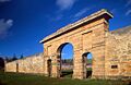
Remains of Norfolk Island gaol
-
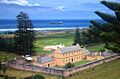
The Old Military Barracks in Kingston
See also
 In Spanish: Isla Norfolk para niños
