
Kermadec Islands facts for kids
|
Rangitāhua
|
|
|---|---|
 |
|
| Geography | |
| Coordinates | 29°16′37″S 177°55′24″W / 29.27694°S 177.92333°W |
| Total islands | around 16 |
| Area | 33.6 km2 (13.0 sq mi) |
| Highest elevation | 516 m (1,693 ft) |
| Administration | |
| Demographics | |
| Population | about 6 |

The Kermadec Islands (called Rangitāhua in Māori) are a group of subtropical islands in the South Pacific Ocean. They are about 800 to 1,000 kilometers (500 to 620 miles) northeast of New Zealand's North Island. They are also a similar distance southwest of Tonga.
These islands are part of New Zealand. Their total land area is 33.6 square kilometers (13.0 square miles). Most of the islands are not inhabited. However, there is a small station on Raoul Island. This station is the northernmost outpost of New Zealand and has a few people living there permanently.
The Kermadec Islands are considered part of New Zealand. They are not part of any specific region or district. Instead, they are an "Area Outside Territorial Authority."
Contents
What's in a Name?
The Kermadec Islands got their name from a French captain. His name was Jean-Michel Huon de Kermadec. He visited the islands in the 1790s. This was part of an expedition led by d'Entrecasteaux.
The word "Kermadec" comes from the Breton language. It means "village" or "residence" of a person named Madec. Madec means "good."
The Māori name for the islands is Rangitāhua. This name is also used for Raoul Island. It means "the Stopping-off Place."
A Look Back in Time
Polynesian people visited the Kermadec Islands a long time ago. They stopped there around the 14th century. Some think they might have visited even earlier, around the 10th century. The first Europeans to arrive were on the ship Lady Penrhyn in 1788. They did not find anyone living on the islands.
In the 1800s, whaling ships from Britain, America, and Australia often visited the islands. They came to find water, wood, and food. The first recorded visit by a whaler was the Fanny in 1823. Some European settlers lived on the islands for different periods. They grew food for the whalers. One family, the Bells, lived on Raoul Island from 1878 to 1914. Their story was later written in a book called Crusoes of Sunday Island.
Raoul Island Station
Since 1937, a special station has been on Raoul Island. It is a government weather and radio station. It also has a place for Department of Conservation staff and volunteers to stay. The station is about 50 meters (164 feet) above the sea. It is New Zealand's northernmost inhabited spot.
Nuclear Testing Proposal
In 1955, the British government was looking for a remote place. They wanted to test new powerful weapons. They considered islands in the South Pacific, including the Kermadec Islands. Since the islands are part of New Zealand, the British Prime Minister asked New Zealand for permission. However, New Zealand's Prime Minister, Sidney Holland, said no. He was worried about how the public would react. Despite pressure, he stood firm.
Island Geography
The Kermadec Islands are located between 29° and 31.5° south latitude. They are between 178° and 179° west longitude. They are about 800 to 1,000 kilometers (500 to 620 miles) northeast of New Zealand's North Island. They are also a similar distance southwest of Tonga. The total land area of all the islands is 33.6 square kilometers (13.0 square miles).
Island Climate
The islands have a subtropical climate. This means they have warm temperatures all year. The average temperature in February is about 22.4°C (72.3°F). In August, it's about 16.0°C (60.8°F). The islands get about 1,500 millimeters (59 inches) of rain each year. There is less rain from October to January.
The Islands of the Group

The Kermadec group includes four main islands and some smaller rocks.
- Raoul Island (or Sunday Island) is the biggest island. It is about 900 kilometers (560 miles) south-southwest of 'Ata, Tonga. It is also 1,100 kilometers (680 miles) north-northeast of New Zealand. Raoul Island is 29.38 square kilometers (11.34 square miles) in size. Its highest point, Moumoukai peak, is 516 meters (1,693 feet) high.
- Macauley Island is the second largest. It is about 110 kilometers (68 miles) south-southwest of Raoul Island. With nearby Haszard Island, its area is 3.06 square kilometers (1.18 square miles).
- Macdonald Rock is about 4 kilometers (2.5 miles) north of Macauley Island.
- Curtis Island is the third largest. It is about 35 kilometers (22 miles) south-southwest of Macauley Island. It is 137 meters (449 feet) high. Its area, with nearby Cheeseman Island, is 0.59 square kilometers (0.23 square miles).
- Nugent Island is the northernmost island. It is about 100 meters (328 feet) across.
- L'Esperance Rock is about 80 kilometers (50 miles) south-southwest of Curtis Island. It is 250 meters (820 feet) across and 70 meters (230 feet) high. Its area is 0.05 square kilometers (0.019 square miles).
- L'Havre Rock is about 8 kilometers (5 miles) north-northwest of L'Esperance Rock. It is usually underwater, except at low tide.
There are also underwater mountains called seamounts north and south of the islands. These are part of a long ridge that connects Tonga to New Zealand.
Island Geology

The Kermadec Islands are part of a volcanic island chain. They formed where two of Earth's giant plates meet. The Pacific Plate is sliding under the Indo-Australian Plate. This process is called subduction. This movement created the Kermadec Trench, a very deep underwater valley (8 kilometers or 5 miles deep) to the east of the islands.
The islands sit on the Kermadec Ridge, an underwater mountain range. This ridge stretches from Tonga to New Zealand. The four main islands are actually the tops of volcanoes that rise above the sea. Many other volcanoes in the chain are underwater.
.jpg)
Raoul and Curtis Islands are active volcanoes. The volcanoes on the other islands are not active right now. The smaller islands are what is left of old, worn-down volcanoes.
In 2012, an underwater volcano called Havre Seamount erupted. It was so powerful that it broke the ocean surface. It created a huge raft of floating rock called pumice.
The islands often experience earthquakes. These are caused by the movement of the Earth's plates and volcanic activity. For example, a strong earthquake happened in March 2021. It caused a tsunami warning for nearby islands.
Island Environment
Plants of the Kermadec Islands
Scientists recognize the Kermadec Islands as a special "ecoregion." This means they have a unique set of plants and animals. The islands are covered in subtropical forests. The most common tree is the red-flowering Kermadec pōhutukawa. This tree is related to the pōhutukawa found in New Zealand.
The islands have 113 types of native plants. Twenty-three of these plants are found only on the Kermadec Islands. There are also many mosses, lichens, and fungi. Most of the plants came from New Zealand or the tropical Pacific. Unfortunately, 152 types of plants have been brought to the islands by humans. These are not native and can sometimes cause problems.
The forests on Raoul Island are very thick. Metrosideros kermadecensis trees form a canopy 10 to 15 meters (30 to 50 feet) high. Another important tree is the native nikau palm (Rhopalostylis baueri). The forests also have many smaller trees, shrubs, ferns, and herbs. Near the seashore, where there is salt spray, different plants grow. These include shrubs and ferns that can handle the salty conditions.
Animals of the Kermadec Islands
The Kermadec Islands do not have any native land mammals. However, they are home to a special type of bird called the Kermadec red-crowned parakeet. This bird is found only here. The islands are also a very important place for many seabirds to breed. These include different types of petrels, shearwaters, and terns.
The waters around the islands are rich with marine life. Many types of whales and dolphins visit these waters. This includes humpback whales, minke whales, sperm whales, and killer whales. Historically, many southern right whales were seen here.
The deep-sea hydrothermal vents along the Kermadec ridge are home to unique creatures. These include the New Zealand blind vent crab. Researchers have also found new types of tropical reef fish in the marine reserve.
Protecting the Islands
In the past, animals brought by humans caused problems for the islands. Cats, rats, and goats damaged the forests and seabird populations. Goats ate so much that they destroyed the forests on Macauley Island. Rats and cats hunted seabirds, causing their numbers to drop.
The New Zealand government has been working to restore the islands. In 1937, the islands were declared a nature reserve. In 1990, the sea around them became a marine reserve. This marine reserve is one of New Zealand's largest, covering 7,480 square kilometers (2,890 square miles).
Goats were removed from Macauley Island in 1970 and from Raoul Island in 1984. Since then, the forests have started to grow back. The islands are still important for birds. Seabirds now nest on small islands offshore, where they are safe from rats and cats. Efforts are ongoing to remove rats, cats, and harmful non-native plants from the main islands.
Visiting the islands is controlled by the Department of Conservation. They allow volunteers to help with restoration projects on Raoul Island. Other visitors can come for scientific study. Visits to the other islands are usually only for scientific research.
In 2015, the New Zealand Prime Minister announced plans for the Kermadec Ocean Sanctuary. This would be a huge protected area of 620,000 square kilometers (240,000 square miles). However, some groups have opposed it, and the plan has not yet been fully approved.
Images for kids
-
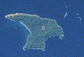
Raoul Island from space
.jpg)
See also
 In Spanish: Islas Kermadec para niños
