Raoul Island facts for kids
Quick facts for kids Raoul Island |
|
|---|---|
| Rangitahua (Māori) Sunday Island |
|

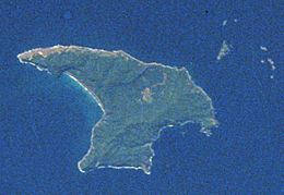
Raoul Island as seen by STS-8 in 1983. Herald Islets at top right. North at top.
|
|
| Highest point | |
| Elevation | 516 m (1,693 ft) |
| Parent peak | Moumoukai Peak |
| Geography | |
| Location | Kermadec Islands |
| Geology | |
| Mountain type | Stratovolcano |
| Volcanic arc/belt | Kermadec Islands |
| Last eruption | March 2006 |
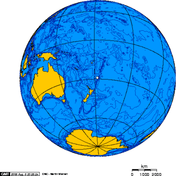
Raoul Island (also known as Sunday Island) is the biggest and most northern of the main Kermadec Islands. It's about 900 kilometers (560 miles) southwest of Tonga's 'Ata Island. It's also about 1100 kilometers (680 miles) northeast of New Zealand's North Island. This island has had many strong volcanic eruptions over thousands of years.
The island is shaped a bit like an anvil. It covers about 29.38 square kilometers (11.34 square miles). This includes smaller islands and rocks nearby. The highest point is Moumoukai Peak, which is 516 meters (1,693 feet) high.
Raoul is the only island in the Kermadec group that's big enough for people to live on. However, it doesn't have a safe harbor. Boats can only land there when the weather is calm. The island has two hilly areas. One has peaks of 516 meters and 498 meters. The other has a peak of 465 meters. A large bowl-shaped area, called a caldera, separates these two hilly parts. This caldera is part of the Raoul volcano.
Contents
Island's Past: A Look at Raoul Island's History
Evidence from old sites on Raoul Island's northern coast shows that Polynesian people lived there in the 14th century. They left behind stone tools, sharp obsidian flakes, shells, and charcoal. Similar obsidian has been found at early Maori sites in New Zealand.
Scientists believe that Raoul Island was settled by people from New Zealand. The Kermadec Islands might have been a stopover point for early Polynesian travelers. These travelers moved between Polynesia and New Zealand. However, people only lived on Raoul Island for a short time.
Who Discovered and Named Raoul Island?
No one was living on the island when Western sailors first saw it. It was named after Joseph Raoul, a quartermaster on the ship Recherche. He saw the island on March 16, 1793. Captain William Raven of the whaling ship Britannia saw the island on March 6, 1796. He called it Sunday Island, which became a common name. Captain Henry Mangles Denham of HMS Herald mapped the island in 1854.
Life on the Island: The Bell Family and Others
The last regular residents were Tom Bell and his wife Frederica. They lived on the island for 36 years. The New Zealand government had to evacuate them in 1914. When a team went to check the island, they saw how quickly the Bells had left. A 1914 calendar was still on the kitchen wall. The family's furniture, dishes, and toys were still in place. The Bell family arrived with six children, and five more were born there.
From May 27 to June 16, 1917, a German ship called Wolf anchored in a protected bay. Its crew worked on the ship's engines. During this time, Wolf captured two other ships. These were the New Zealand steamship Wairuna and the American sailing ship Winslow. The German crew took all the cargo and coal from both ships.
Raoul Island Station: New Zealand's Northern Outpost
The New Zealand government has had people living and working on Raoul Island since 1937. This is called the Raoul Island Station. It includes a government weather and radio station. It also has a place for Department of Conservation (DOC) staff and volunteers to stay. The station is on the northern terraces of the island. It sits about 50 meters (160 feet) above the cliffs of Fleetwood Bluff.
In 1939, the New Zealand government made Raoul the island's official name. This was likely to avoid confusion with other Sunday islands in Australia. Raoul Island Station is New Zealand's northernmost outpost.
Volcanic Activity: The 2006 Eruption
On March 17, 2006, a volcano erupted at Green Lake. The eruption lasted for 40 seconds. A DOC worker named Mark Kearney was at the crater measuring water temperature. An area of 5 hectares (12 acres) around Green Lake was covered in ash, mud, and rocks. Two other DOC workers tried to find Kearney but had to turn back.
After the eruption, DOC decided to evacuate the remaining five staff members. A helicopter and a plane flew from Taupo that morning. They arrived at the island in the late afternoon. They searched for Kearney for 45 minutes but found no sign of him. The evacuated staff were flown back to Auckland that evening.
A Royal New Zealand Air Force plane flew over the island on March 21. It gathered more information on how safe it was to approach Green Lake. Volcanologists on board decided the area was still unsafe. They noted that the crater lake had risen by about 8 meters (26 feet). There was no cloud or ash plume.
A group of police, the evacuated workers, and scientists went back to Raoul. They traveled on a boat called the RV Braveheart. They were able to do a limited search. They decided it was very unlikely that Kearney had survived. The area around Green Lake was completely destroyed. The Braveheart returned to the mainland on March 25. Three DOC workers stayed on the island to continue research. The other four evacuated workers joined them in May 2006.
Five hours after the eruption, a satellite passed over the island. It found that about 200 tons of sulfur dioxide had been released. This showed that magmatic gases were part of the eruption. It also meant that magma was releasing gas inside the volcano. By the end of April, the activity had greatly decreased. The "Alert Level" for the volcano was lowered to 1.
A New Zealand Navy ship, HMNZS Te Mana, went to Raoul on August 24, 2006. It was on a mission to resupply the island. Kearney's sister, Merryn McDermott, was also on board. Three representatives from the Ngāti Kurī iwi (tribe) were there too. Chris Carter, the Minister of Conservation, also joined the trip. During a service on August 28, the Ngāti Kurī representatives performed a tapu lifting ceremony. A plaque was put up to honor Kearney. Te Mana also helped with volcanic monitoring. Its helicopter collected water samples from the crater lake.
A report about Kearney's death was released on October 14, 2006. It stated that the eruption was unpredictable. There was no sign of an earthquake or other activity beforehand. The report cleared the Conservation Department and Geological and Nuclear Sciences of any fault.
Earthquakes Near Raoul Island
The Kermadec Islands are located where two tectonic plates meet. This means they often experience earthquakes. A very strong earthquake happened on March 4, 2021. It measured 8.1 on the moment magnitude scale. This is classified as a 'major' earthquake. Its center was south of Raoul Island.
Another notable earthquake happened on January 31, 2007. It was a Magnitude 6.5 earthquake. Its center was about 40 km (25 mi) south of Raoul. It was about 10 km (6 mi) below the seabed. On December 9, 2007, a Magnitude 7.6 earthquake shook the area. It was centered about 350 km (220 mi) north of Raoul Island. Its depth was about 188 km (117 mi).
On September 30, 2008, a Magnitude 7.0 earthquake occurred. It was centered 70 km (43 mi) south of Raoul. Its depth was about 35 km (22 mi). More recently, on October 22, 2011, a Magnitude 7.4 earthquake happened. It originated at a depth of 39 km (24 mi).
July 2011 Earthquake
On July 7, 2011, a 7.6 Magnitude earthquake happened. It was at a depth of 24 km (15 mi). The earthquake was 211 km (131 mi) east of Raoul Island. A scientist said the quake caused a 1.9 meter (6.2 feet) tsunami at Raoul Island.
October 2011 Earthquake
On October 22, 2011, a 7.4 magnitude earthquake occurred. It was at a depth of 45 meters (148 feet). The earthquake was 230 km (140 mi) east of Raoul Island.
The Ministry of Civil Defence issued a warning. They told people in coastal areas to stay off beaches and out of the water. People were advised to avoid sightseeing. They were told to stay alert in case of a tsunami. However, warnings were lifted by mid-morning.
March 2021 Earthquake
On March 4, 2021, an 8.1 magnitude earthquake occurred. It was at a depth of 26.5 km (16.5 mi). The earthquake was 4 km (2.5 mi) east of Raoul Island. Due to the COVID-19 pandemic, no one was living on the island at that time. The earthquake caused a tsunami warning for much of New Zealand. Some coastal areas of the North Island were evacuated.
Island Features: Exploring Raoul Island's Geography
Raoul Island has two large, bowl-shaped areas called Holocene calderas. These were formed by huge volcanic eruptions. The older caldera is in the center of the island. It is about 3.5 by 2.5 kilometers (2.2 by 1.6 miles) wide. The Denham caldera formed about 2200 years ago. It is 6.5 by 4 kilometers (4.0 by 2.5 miles) wide.
Volcanic eruptions at Raoul in the 1800s and 1900s sometimes happened from both calderas at once. These were small to medium eruptions. Some of them created temporary islands in the Denham caldera. A 240-meter (790-foot) high underwater volcano cone has also erupted. This cone is on the lower side of Raoul volcano.
The Denham caldera was named after nearby Denham Bay. Captain Henry Mangles Denham of the Royal Navy named the bay. He came to map the island on July 2, 1854. His 16-year-old son, Fleetwood James Denham, died from a tropical fever. He was buried near the beach in Denham Bay. Many other settlers were also buried there. A brass plaque from his grave has been kept.
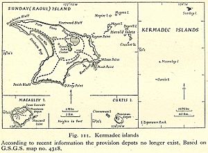
Three small lakes are found in the northern caldera of Raoul Island. They are Blue Lake, Green Lake, and Tui Lake. Blue Lake is about 1.17 square kilometers (0.45 sq mi). Green Lake is about 160,000 square meters (1,700,000 sq ft). Tui Lake is about 5,000 square meters (54,000 sq ft) and has drinking water. The flat areas around the lakes are called Pumice Flats.
Raoul Island's Weather: Understanding the Climate
Raoul Island has a humid subtropical climate. This means it has warm, humid summers and mild winters.
| Climate data for Raoul Island | |||||||||||||
|---|---|---|---|---|---|---|---|---|---|---|---|---|---|
| Month | Jan | Feb | Mar | Apr | May | Jun | Jul | Aug | Sep | Oct | Nov | Dec | Year |
| Record high °C (°F) | 31.0 (87.8) |
30.2 (86.4) |
29.5 (85.1) |
28.4 (83.1) |
25.6 (78.1) |
24.2 (75.6) |
23.5 (74.3) |
23.0 (73.4) |
23.1 (73.6) |
25.0 (77.0) |
26.7 (80.1) |
28.7 (83.7) |
31.0 (87.8) |
| Mean daily maximum °C (°F) | 25.0 (77.0) |
25.7 (78.3) |
24.9 (76.8) |
23.6 (74.5) |
21.7 (71.1) |
20.1 (68.2) |
19.1 (66.4) |
19.0 (66.2) |
19.6 (67.3) |
20.5 (68.9) |
22.0 (71.6) |
23.6 (74.5) |
22.1 (71.8) |
| Daily mean °C (°F) | 22.3 (72.1) |
23.1 (73.6) |
22.4 (72.3) |
20.9 (69.6) |
19.0 (66.2) |
17.4 (63.3) |
16.4 (61.5) |
16.1 (61.0) |
16.8 (62.2) |
17.7 (63.9) |
19.2 (66.6) |
20.9 (69.6) |
19.3 (66.7) |
| Mean daily minimum °C (°F) | 19.7 (67.5) |
20.5 (68.9) |
19.9 (67.8) |
18.3 (64.9) |
16.4 (61.5) |
14.8 (58.6) |
13.7 (56.7) |
13.3 (55.9) |
14.0 (57.2) |
14.9 (58.8) |
16.4 (61.5) |
18.2 (64.8) |
16.7 (62.1) |
| Record low °C (°F) | 13.6 (56.5) |
14.3 (57.7) |
13.4 (56.1) |
10.5 (50.9) |
10.4 (50.7) |
9.0 (48.2) |
8.1 (46.6) |
7.4 (45.3) |
8.5 (47.3) |
9.3 (48.7) |
10.4 (50.7) |
12.5 (54.5) |
7.4 (45.3) |
| Average precipitation mm (inches) | 128 (5.0) |
153 (6.0) |
162 (6.4) |
102 (4.0) |
129 (5.1) |
171 (6.7) |
150 (5.9) |
132 (5.2) |
110 (4.3) |
86 (3.4) |
94 (3.7) |
141 (5.6) |
1,558 (61.3) |
| Mean monthly sunshine hours | 276.4 | 244.8 | 201.2 | 168.3 | 148.4 | 129.6 | 144.5 | 168.6 | 199.4 | 228.4 | 219.8 | 258.6 | 2,388 |
| Source 1: NIWA National Climate Database | |||||||||||||
| Source 2: Météo Climat (extremes) | |||||||||||||
Nature's Wonders: Flora and Fauna of Raoul Island
Scientists began studying the plants and animals of Raoul Island in 1854. This was when HMS Herald, led by Captain Henry Mangles Denham, arrived. Naturalists on board, William Grant Milne and John MacGillivray, collected plants. These plants were later described by Sir Joseph Hooker.
In 1908, a scientific trip explored the Kermadec Islands. They set up their base at Denham Bay. During this trip, a naturalist named W. L. Wallace found many new insect species. This included a beetle called Saprosites raoulensis.
Raoul Island is part of the Kermadec Islands subtropical moist forests area. Most of the island is covered with thick forests. The main trees are the Kermadec pōhutukawa and the Kermadec nikau palm. The island is just far enough south that coconuts washing ashore usually don't survive. This is because it's not warm enough for them long-term.
Animals of Raoul Island: Birds and Other Creatures
The island has no native land mammals. It used to be home to huge groups of seabirds. These birds nested in the forests. The islands might have once had a type of megapode bird and a subspecies of kereru (a native pigeon).
Today, native landbirds on the island include the Kermadec red-crowned parakeet. You can also find the Australasian harrier, pukeko, and tui. Several bird species have also been introduced to the island. Raoul Island is an Important Bird Area. This means it's a key place for seabirds to nest.
Challenges and Conservation: Protecting Raoul Island's Wildlife
Polynesian visitors brought Polynesian rats to the island in the 14th century. Later, European and American visitors introduced Norway rats, cats, and goats. These animals caused big problems for the seabirds. The rats and cats greatly reduced the seabird groups. Most seabirds moved to smaller islands offshore. They also caused the red-crowned parakeet to disappear from the main island. The last confirmed sighting of these parakeets was in 1836.
Goats didn't destroy all the trees, but they ate many of the smaller plants. The goats were removed in 1986. The Department of Conservation removed rats and cats between 2002 and 2006. After this, red-crowned parakeets naturally returned to the island. They likely came from the Herald Islets, which are 2 to 4 kilometers (1.2 to 2.5 miles) away. The parakeets had been gone for 150 years. Their return was a big success for parrot conservation.
There are many invasive plant species on the island. Teams of DOC workers and volunteers have been working for years to remove them. A plant disease called Myrtle Rust was found on the island in 2017.
The island is part of the Kermadec Islands Marine Reserve. This is New Zealand's largest marine reserve, created in 1990.
Nearby Islands and Rocks
The two largest islands near Raoul are North Island and South Island of Meyer Islands.
- Islands and rocks to the northeast of Raoul Island:
- Fishing Rock
- Egeria Rock
- Meyer Islands
- North Island
- South Island
- Napier
- Nugent Island (the northernmost island of New Zealand)
- Herald Islets
- Dayrell Island
- Chanter Islands
- Chanter (North) Island
- South Island
- West Island
- Islands and rocks to the southwest of Raoul Island:
- Milne Islands
- Dougall Rocks
 | James Van Der Zee |
 | Alma Thomas |
 | Ellis Wilson |
 | Margaret Taylor-Burroughs |


