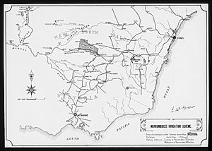
Murrumbidgee Irrigation Area facts for kids
Quick facts for kids Irrigation in the Riverina area of New South Wales, Australia |
|
|---|---|
| Irrigated area | 660,000 hectares (1,600,000 acres) |
| Water sources for irrigation |
|
| Annual investment in irrigation | A$5 billion |
The Murrumbidgee Irrigation Area (MIA) is a special farming region in the Riverina area of New South Wales, Australia. It was created to help farmers grow food by controlling river water. The main rivers that supply water to the MIA are the Murrumbidgee and the Tumut. This area is very important for Australia. It produces many different kinds of food and adds over $5 billion to the country's economy each year.
Contents
What is the Murrumbidgee Irrigation Area?
The Murrumbidgee Irrigation Area, or MIA, is a large farming region. It uses a clever system of dams and canals to bring water to farms. This water helps grow crops in an area that might otherwise be too dry. It's like giving a big drink to thirsty land so plants can grow well.
Why Was the MIA Created?
In the 1880s, people in New South Wales realised they needed a better way to manage water. They held a special meeting called a Royal Commission. This meeting decided that controlling water from rivers would help grow more food. That's how the idea for the MIA began.
Building the MIA
Work on the MIA started in 1903. The first step was building canals west of a town called Narrandera. Then, they began building a very important dam called Burrinjuck Dam. This dam would hold a lot of water for the new farming area.
How the MIA Grew Over Time
The Murrumbidgee Irrigation Area officially opened in 1912, after Burrinjuck Dam was finished. But it didn't stop there!
More Water and Power
In the 1970s, the MIA got even bigger. This happened after the huge Snowy Mountains Scheme was completed. This scheme helped build another dam, Blowering Dam, on the Tumut River. The Tumut River joins the Murrumbidgee River near Gundagai. Later, Burrinjuck Dam was made even larger. This meant more water for farms and also the ability to make clean electricity using the water.
A Major Engineering Achievement
The MIA is still seen as an amazing feat of engineering. It has a complex network of:
- Weirs (small dams that raise water levels)
- Canals (man-made rivers to carry water)
- Holding ponds (areas to store water)
All these parts work together to bring water from upstream rivers and dams to the farms.
Towns of the MIA
Many towns in the Murrumbidgee Irrigation Area were specially built for the project. These include Leeton and Griffith. These towns were designed to support the farming communities.
Growing Communities
Today, Leeton and Griffith are still busy and growing towns. They offer many jobs related to farming and water management. It's quite special to see these inland towns growing so fast in central New South Wales. This shows how unique and successful the MIA has been.
Who Designed the Towns?
The plans for the towns of Griffith and Leeton were created in 1914. They were designed by an American architect and town planner named Walter Burley Griffin. He was famous for winning the competition to design Australia's capital city, Canberra, in 1912.
 | Victor J. Glover |
 | Yvonne Cagle |
 | Jeanette Epps |
 | Bernard A. Harris Jr. |


