Tumut River facts for kids
Quick facts for kids Tumut |
|
|---|---|

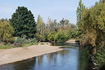
Tumut River, near Tumut, New South Wales
|
|
|
Location of the Tumut River mouth in New South Wales
|
|
| Native name | Bewuck |
| Other name(s) | Doomut |
| Country | Australia |
| State | New South Wales |
| Region | Australian Alps (IBRA), South Eastern Highlands (IBRA), Snowy Mountains, South West Slopes |
| Municipalities | Tumut, Gundagai |
| Physical characteristics | |
| Main source | Toolong Range, Snowy Mountains west of Mount Jagungal 1,430 m (4,690 ft) 36°5′18″S 148°23′5″E / 36.08833°S 148.38472°E |
| River mouth | confluence with the Murrumbidgee River near Gundagai 220 m (720 ft) 35°1′18″S 148°10′51″E / 35.02167°S 148.18083°E |
| Length | 182 km (113 mi) |
| Basin features | |
| River system | Murrumbidgee catchment, Murray–Darling basin |
| Basin size | 4,000 km2 (1,500 sq mi) |
| Tributaries |
|
| Dams | Happy Jacks, Tumut Pond, Tumut Two, Talbingo, Jounama, Blowering |
The Tumut River is a cool river in New South Wales, Australia. It's like a long, flowing stream that never dries up. This river is part of the bigger Murrumbidgee River system. It also belongs to the huge Murray–Darling basin, which is a very important river network in Australia.
The Tumut River flows through the Snowy Mountains and the South West Slopes areas. It's known for its beautiful scenery and its role in a big power project.
Contents
River's Journey: Source to Mouth
The Tumut River starts high up in the Snowy Mountains. Its source is on the northern side of Mount Jagungal, about 1,430 metres (4,690 ft) above sea level. From there, it flows mostly towards the north and west.
Along its journey, many smaller streams join the Tumut River. These are called tributaries. Some important ones include Doubtful Creek, Happy Jacks Creek, and Goobarragandra River. Finally, after flowing for about 182 kilometres (113 mi), the Tumut River joins the Murrumbidgee River. This meeting point is near the town of Gundagai. The river drops about 1,210 metres (3,970 ft) in height from its start to where it meets the Murrumbidgee.
How the Snowy Mountains Scheme Changed the River
The Tumut River's natural flow has been changed a lot by a huge project called the Snowy Mountains Scheme. This project was built between 1949 and 1974. Its main goal was to create electricity and move water for farming.
The scheme built many dams and power stations. Six dams were built on the Tumut River itself. These include Happy Jacks Dam, Tumut Pond Dam, and Blowering Dam. These dams hold back water to create power and control the river's flow.
Even though the Tumut River isn't super long, it naturally carries a lot of water. This is because it collects melted snow and rain from a big part of the northern Snowy Mountains. The Snowy Mountains Scheme also adds more water to the Tumut River. Water is moved from other rivers, like the Tooma River and Lake Eucumbene, into the Tumut River.
A special bridge called the Junction Bridge crosses the Tumut River near the town of Tumut. This bridge is very old and important to the area's history.
River's Name: What Does Tumut Mean?
The name "Tumut" comes from the Wiradjuri people. They are the Aboriginal people who traditionally lived in this area. In their language, the word doomut or doomat means "camping by the river." This shows how important the river was to them for living and traveling.
Caring for the Tumut River: Environmental Concerns
The Tumut River is very important, but it has faced some challenges. Because of how the river's flow is managed for electricity and farming, there have been some environmental worries.
Here are some of the concerns:
- River Bank Erosion: The strong, unnatural flows of water can wash away the soil from the river banks. This means land is lost along the river.
- Waterlogged Land: Low-lying areas next to the river can become too wet. This is called waterlogging and can harm the plants and soil.
- Cold Water: Water released from the bottom of dams, like Blowering Dam, is very cold. This cold water changes the river's temperature, which can be bad for native fish and other animals.
- Loss of Wildlife: Animals like platypuses can struggle because the water levels change so much. Sometimes the water is very high for farming, and other times it's very low in winter. These big changes make it hard for them to live.
- Blocked Waterways: Some old side channels of the river, called anabranches, can get cut off from the main river. This affects the natural flow and habitats.
People are working to find ways to manage the river better. The goal is to make sure the river can still provide water and power, but also stay healthy for its plants and animals.
Fun on the Tumut River: Activities and Sports
The Tumut River is a great place for outdoor activities! Many people enjoy spending time here.
- Canoeing and Kayaking: The river is popular for paddling, especially downstream from Blowering Dam. It's best to go when the water flow is higher, as it can be tricky to paddle when the water is very low in winter. The Tumut Valley Canoe Club often paddles here.
- Fishing: If you like fishing, the Tumut River is a good spot for cold-water fish, like different types of trout. However, because the water is so cold from the dam releases, it's not as good for native fish species.
 | Tommie Smith |
 | Simone Manuel |
 | Shani Davis |
 | Simone Biles |
 | Alice Coachman |


