City of Lithgow facts for kids
Quick facts for kids City of LithgowNew South Wales |
|||||||||||||||
|---|---|---|---|---|---|---|---|---|---|---|---|---|---|---|---|

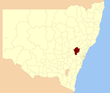
Location in New South Wales
|
|||||||||||||||
| Population |
|
||||||||||||||
| • Density | 4.5797/km2 (11.861/sq mi) | ||||||||||||||
| Area | 4,551 km2 (1,757.2 sq mi) | ||||||||||||||
| Mayor | Maree Statham (Unaligned) | ||||||||||||||
| Council seat | Lithgow | ||||||||||||||
| Region | Central West | ||||||||||||||
| State electorate(s) | Bathurst | ||||||||||||||
| Federal Division(s) | |||||||||||||||
 |
|||||||||||||||
| Website | City of Lithgow | ||||||||||||||
|
|||||||||||||||
The City of Lithgow is a special area in New South Wales, Australia. It is called a local government area. This means it has its own council that helps run things for the people living there.
The City of Lithgow is in the Central West part of New South Wales. You can find it near the Great Western Highway. This is a major road. It's also close to the Main Western railway line. This is an important train track.
The person in charge of the City of Lithgow Council is the mayor. The current mayor is Cr. Maree Statham. She is an independent mayor. This means she is not part of a big political party.
Contents
Towns and Villages
The main city in this area is Lithgow. It is the biggest centre where many people live and work.
The City of Lithgow also includes many other towns and villages. These are smaller communities. They are important parts of the area.
Some of these towns and villages are:
- Bell
- Ben Bullen
- Bogee
- Bowenfels
- Capertee
- Clarence
- Cullen Bullen
- Dargan
- Glen Alice
- Glen Davis
- Hampton
- Hartley
- Hartley Vale
- Little Hartley
- Marrangaroo
- Meadow Flat
- Newnes
- Portland
- Rydal
- Sodwalls
- Tarana
- Wallerawang
Who Lives in Lithgow?
Understanding who lives in an area is called demographics. It helps us learn about the people there.
In 2021, about 20,842 people lived in the City of Lithgow. This number comes from the Australian Bureau of Statistics. It shows how many people call this area home.
How the Council Works
The Lithgow City Council is made up of nine people. These people are called councillors. They are chosen by the community to represent them.
Choosing Councillors
Councillors are elected by the people living in the area. This happens through a special voting system. It ensures that different groups of people are fairly represented. All councillors are elected for a four-year period.
After the election, the councillors meet for the first time. They then choose one of themselves to be the mayor. The mayor leads the council meetings.
Current Council Members
In the most recent election (held on 4 December 2021), all nine councillors elected were Independent or Unaligned. This means they do not belong to a major political party.
| Party | Councillors | |
|---|---|---|
| Independent and Unaligned | 9 | |
| Total | 9 | |
Election Information
You can find more details about the 2021 local elections for Lithgow. This information shows how people voted.
Special Historic Places
The City of Lithgow has many places that are "heritage-listed." This means they are very old and important. They are protected because they tell us about the past. These sites help us understand the history of the area.
Here are some of these special heritage-listed sites:
- Ben Bullen, Wallerawang-Gwabegar railway: Ben Bullen railway station
- Bowenfels, Great Western Highway: Fernhill, Bowenfels
- Bowenfels, via Kirkley Street: Lithgow Heavy Anti Aircraft Gun Stations and Dummy Station
- Bowenfels, Main Western railway: Bowenfels railway station
- Bowenfels, Main Western railway: Bowenfels rail viaducts
- Hartley, Great Western Highway: Hartley historic site
- Hartley, 200 Jenolan Caves Road: Military Station archaeological site
- Hartley, The Old Bathurst Road: Cox's Road and Early Deviations - Hartley, Clarence Hilly Range and Mount Blaxland Precinct
- Hartley Vale, Hartley Vale Road: Collits' Inn
- Lithgow, Bent Street: Lithgow Valley Colliery and Pottery Site
- Lithgow, Brewery Lane: Lithgow Zig Zag
- Lithgow, Gas Works Lane: Lithgow Coal Stage Signal Box
- Lithgow, Inch Street: Lithgow Blast Furnace
- Lithgow, Jenolan Caves Road: McKanes Falls Bridge
- Lithgow, Main West Line 156.334 km, James Street: Lithgow Underbridge
- Lithgow, Main Western railway: Eskbank railway station, New South Wales
- Lithgow, Main Western railway: Ten Tunnels Deviation
- Lithgow, Railway Parade: Lithgow railway station
- Lithgow, Top Points Zig Zag railway: Cooerwull railway footbridge
- Marrangaroo, Main Western railway: Marrangaroo railway viaduct
- Old Bowenfels, 70 Mudgee Street: Bowenfels National School Site
- Portland, Carlton Road: Raffan's Mill and Brick Bottle Kilns
- Portland, Williwa Street: Portland Cement Works Precinct
- Rydal, Main Western railway: Rydal railway station
- Rydal, Main Western railway: Rydal rail underbridges
- Sodwalls, off Cuthill Road: Cox's Road and Early Deviations - Sodwalls, Fish River Descent Precinct
- Tarana, Main Western railway: Tarana railway station
- Wallerawang, Main Street: St John the Evangelist Church, Wallerawang
- Wallerawang, Main Western railway: Coxs River railway bridges, Wallerangang
- Wallerawang, Main Western railway: Wallerawang railway station
- Wambool, Main Western railway: Wambool old-rail truss overbridges
 | May Edward Chinn |
 | Rebecca Cole |
 | Alexa Canady |
 | Dorothy Lavinia Brown |

