
Glen Davis, New South Wales facts for kids
Quick facts for kids Glen DavisNew South Wales |
|||||||||||||||
|---|---|---|---|---|---|---|---|---|---|---|---|---|---|---|---|
Glen_Davis.jpg)
Countryside around Glen Davis
|
|||||||||||||||

Glen Davis
Location in New South Wales
|
|||||||||||||||
| Population | 115 (2016 census) | ||||||||||||||
| Postcode(s) | 2846 | ||||||||||||||
| Elevation | 290 m (951 ft) | ||||||||||||||
| Location | |||||||||||||||
| LGA(s) | City of Lithgow | ||||||||||||||
| State electorate(s) | Bathurst | ||||||||||||||
| Federal Division(s) | Calare | ||||||||||||||
|
|||||||||||||||
Glen Davis is a small village in the Central Tablelands of New South Wales, Australia. It's part of the City of Lithgow area. The village is about 250 kilometers (155 miles) north-west of Sydney. It's also about 80 kilometers (50 miles) north of Lithgow. The name "Glen Davis" also refers to the surrounding area for mail and official records. In 2016, about 115 people lived in Glen Davis.
Contents
Where is Glen Davis?
Glen Davis is located in the Capertee Valley, where the Capertee River begins its journey. It's found north of Lithgow, along the road that leads to Mudgee. The village sits just east of the Great Dividing Range. This means the Capertee River is part of the Hawkesbury-Nepean river system. The closest town is Capertee. This town used to have the nearest train connection to Glen Davis.
Glen Davis was built here because there were large amounts of oil shale and coal nearby. However, its location had some challenges. It was quite far away from other places. It also didn't get much rain, and parts of the village could flood during heavy storms.
A Look at Glen Davis's Past
Early Days in the Valley
First People and Settlers
The Wiradjuri people are the original inhabitants of the Capertee Valley. This includes the area we now call Glen Davis. The valley is in the north-eastern part of the Wiradjuri lands. It is close to the lands of the Darkinyung people.
European settlers started arriving in the valley in the 1820s. They gradually cleared the land for farming and raising animals.
Early Mining Efforts
In 1865, oil shale was discovered in the Capertee Valley. Mining for it began in 1881. One of the early mining sites was where the Glen Davis shale mine would later be built.
In the early 1900s, a small settlement called North Newnes existed. It was near a tunnel being dug to connect the Capertee Valley with oil shale operations in the Wolgan Valley at Newnes. This tunnel was very long, but work on it stopped in 1906. Miners left the area by 1908. These early mining attempts didn't produce much shale. It was too hard and expensive to transport the shale out of the remote valley.
The Shale Oil Town (1938–1952)
From 1938, the area around Glen Davis became important for the oil shale industry again. The town was officially created in December 1939. It was named after George Francis Davis. Glen Davis was special because it was the first time a new town in New South Wales was planned from scratch.
Building the Glen Davis Shale Oil Works started in 1938. The first workers lived in tents or built their own simple homes. This area was called the 'Bag Town' because many homes were made from cheap materials like hessian bags. So, Glen Davis had the planned town, the 'Bag Town' across the river, and housing for staff near the works.
The Glen Davis Oil Shale Works began making shale oil in January 1940. The town's post office opened in March 1939, and the school opened in January 1940. People could buy land to build houses, and a special scheme helped them finance their homes.
In 1947, about 1,600 people lived in Glen Davis. There were brick houses for staff, a hostel, and many homes owned by individuals. There were also barracks for single men and a hotel. The 'Bag Town' still had many simple homes. The school had 260 students and 7 teachers. The town had a post office, a bank, and a police station. There was also a doctor, a pharmacist, churches, a community center, and sports facilities. There were a few shops, like general stores, a pharmacy, and a garage. There was even a movie theater in the 'Bag Town'.
After World War II, new migrants came to the town from 1948. They helped with the shale oil work. At its busiest, Glen Davis had about 2,000 people. It had an ambulance station and a bakery. From 1949, the town had a piped water supply. This water came from the Oberon Dam, over 105 kilometers (65 miles) away.
The Town's Decline
The oil works and mines closed in May 1952. This happened because the works were losing money. By late 1952, many houses in the town were empty. Homeowners received some money from the government. Equipment from the plant was sold off in early 1953. The ambulance station closed, and the town started to look neglected. The population dropped to 460.
By mid-1954, only 320 people lived there. Most shops had closed, and the town lost its doctor and police station. Empty buildings were damaged by vandals. The population kept falling, reaching 195 by late 1954. Only a few places like the hotel, post office, and a shop or two remained open sometimes. Many houses were moved or torn down. The school closed in February 1962, and the post office closed in October 1986.
Glen Davis Today
The creation of the Wollemi National Park has brought some tourism to the area. The old ruins of the oil shale works are now a small tourist attraction. Some old town buildings are now used for tourist accommodation. This includes the hotel and former managers' cottages. The parkland in the center of the old town is now the Glen Davis Campground. A cool fact is that the village still gets its fresh water from the Oberon Dam through the original pipeline.
National Parks Nearby
The Wollemi National Park is huge, covering almost 500,000 hectares (1.2 million acres). It's the second-largest national park in New South Wales. Parts of the Capertee Valley, especially downstream from Glen Davis, are within this park. The National Parks and Wildlife Service created a walking track between Glen Davis and Newnes. This track is called the Pipeline Pass and is popular with hikers. Bushwalkers also use Glen Davis as a starting point for camping trips in the national park. There is also a campsite in the town itself.
Two smaller parks are also nearby: the Mugii Murum-ban State Conservation Area and the Capertee National Park. The Mugii Murum-ban area is very important to the Wiradjuri people.
Another national park, the Gardens of Stone National Park, was created later. This park includes areas around the Capertee Valley, like a flat-topped mountain called Pantony's Crown. This mountain was named after an early farmer. The National Trail, a very long walking trail that goes across Australia, also passes through the Capertee Valley.
Glen Davis in Movies
The town was featured in a documentary film called No Such Place in 1981. This was the first film made by Australian director Peter Butt.
The Glen Davis Shale Oil Works and a nearby property were used as filming locations for the 1980 Australian movie The Chain Reaction. This movie was directed by Ian Barry. It starred actors like Mel Gibson (who wasn't credited), Steve Bisley, and Hugh Keays-Byrne. Many local people from Glen Davis appeared in the movie as extras.
Images for kids
-
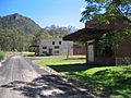
Part of Glen Davis, with a backdrop of the Wollemi National Park. The hotel is at the centre of the photograph.
-
Abandoned shops in Market Place, Glen Davis (Jan. 2005)
-
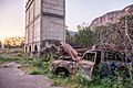
Ruins of Glen Davis Shale Oil Works.
-
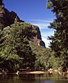
Capertee River downstream of Glen Davis
-
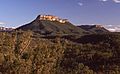
Pantonys Crown, west of Glen Davis
-
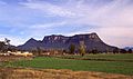
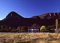
Mount Gundangaroo seen from Glen Davis
-
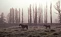
Farmland, Glen Davis
-
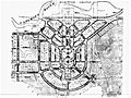
Town Plan of Glen Davis (1939)
-
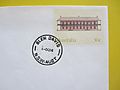
Postmark of the former post office at Glen Davis, made on the day that it closed, 1 October 1986.
-
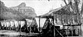
Workers' camp c. 1940 before there was sufficient housing in the new town of Glen Davis.
Glen_Davis-2.jpg)


Capertee_River-1.jpg)
Pantonys_Crown_Capertee_Valley.jpg)
Glen_Davis_view_Mt_Gundangaroo.jpg)
Glen_Davis_morning_mist-1.jpg)
.jpg)

.jpg)
