
Capertee Valley facts for kids
Quick facts for kids Capertee Valley |
|
|---|---|
.jpg)
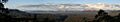
View from the southern side of the valley
|
|
| Width | 30 km (19 mi) |
| Depth | 1.6 km (1 mi) |
| Geology | |
| Age | Triassic |
| Geography | |
| Location | New South Wales, Australia |
| Population centers | Glen Davis |
| Borders on | South Eastern Highlands |
| Topo map | Wallerawang 8931 (1:100000) |
| Traversed by | James Blackman |
The Capertee Valley (say "Kay-per-tee") is a huge canyon in New South Wales, Australia. It's about 135 km (84 mi) north-west of Sydney. This valley is known as the second widest canyon in the world. It's even wider than the famous Grand Canyon!
You can find the Capertee Valley between the towns of Lithgow and Mudgee. It sits in the Central Tablelands, just above the Blue Mountains. The only small village in the valley is Glen Davis. This village has a camp-site and is a great starting point for bushwalking adventures. You can explore the Capertee River and other parts of the Wollemi National Park from here.
Contents
Exploring Capertee Valley's Geology
The Capertee Valley was formed by the Capertee River. This river carved its way through the Sydney Basin. The basin is made of sedimentary rock from the Permian and Triassic periods. These rocks were laid down millions of years ago.
You'll see amazing sandstone cliffs and limestone formations. These tall walls drop down into a deep valley. This valley was shaped by nature over millions of years. One of the most striking sights is Pantony's Crown. This is a tall sandstone butte, like a flat-topped hill. It's now part of the Gardens of Stone National Park. The Capertee Valley is about 1 kilometre wider than the Grand Canyon. However, it is not as deep.
A Look at Capertee Valley's History

Who Lived Here First?
The first people to live around the Capertee Valley were the Aboriginal Wiradjuri people. We know this from ancient rock art found in the area. This art is about 2,000 years old. It shows stencilled hands, boomerangs, and throwing sticks. These images tell us about their lives long ago.

European Settlement and Growth
The Capertee Valley was first explored by an English explorer, James Blackman, in 1821. This was a big step for European settlers. In the 1840s, people started sheep farming here. The area became known for its excellent wool. You can still see old tracks in the valley. These were used by people, horses, and carts.
The Australian gold rush began in 1851. This brought many more people to the colony. The small Capertee Village grew from simple inns. The valley became more important as coal, shale-oil, and limestone were found. These valuable resources were then mined.
In 1882, a railway line was built. This helped the area grow even more. New homes, inns, and a post office appeared. The Glen Davis Shale Oil Works was also built. This factory extracted oil from shale rock. The village became a popular rest stop for travellers going to Mudgee. This was because it had a good water supply. The famous Australian poet Henry Lawson even mentioned the valley in his 1891 poem Song of the Old Bullock Driver. In the 1920s, bushrangers (outlaws) sometimes hid stolen cattle in the valley. The valley became very important in the 1930s. This was due to its huge underground rock deposits. An Art Deco style hotel was also built during this time.
Amazing Birds of Capertee Valley
The Capertee Valley is a very special place for birds. BirdLife International has called it an Important Bird Area. This is because it's the most important breeding spot for the endangered regent honeyeater. This beautiful bird needs our protection.
The valley is also home to other unique birds. You might see the painted honeyeater or the rockwarbler. The swift parrot, plum-headed finch, and diamond firetail also live here. Chris Santella, an author, wrote a book called Fifty Places to Go Birding Before You Die. He listed Capertee Valley as one of only two places in Australia. It's considered one of the top 50 bird watching spots in the world!
Images for kids
-
Panoramic view of the Capertee Valley
