Wallerawang facts for kids
Quick facts for kids WallerawangNew South Wales |
|||||||||||||||
|---|---|---|---|---|---|---|---|---|---|---|---|---|---|---|---|

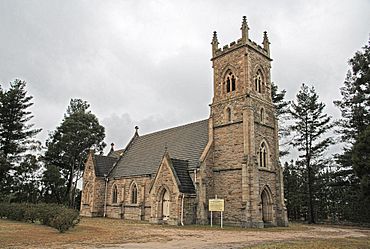
St John the Evangelist Church, built 1881
|
|||||||||||||||
| Population | 1,980 (2016) | ||||||||||||||
| Elevation | 890 m (2,920 ft) | ||||||||||||||
| Location | |||||||||||||||
| LGA(s) | City of Lithgow | ||||||||||||||
| Region | Central Tablelands | ||||||||||||||
| County | Australia | ||||||||||||||
| State electorate(s) | Bathurst | ||||||||||||||
| Federal Division(s) | Calare | ||||||||||||||
|
|||||||||||||||
Wallerawang is a small town in the Central Tablelands area of New South Wales, Australia. It is about 14 kilometers northwest of Lithgow. The town is located right next to the Great Western Highway. It is also on the Main Western railway line. This is where the Gwabegar line also connects. The name Wallerawang is used for the surrounding area for mail and official records.
Contents
The History of Wallerawang
Early Days and First Visitors
The first people to live in the area west of the Blue Mountains were the Wiradjuri Aboriginal Australians. They are believed to have called this place Waller-owang. This name likely means 'place near wood and water' or 'plenty of water'.
James Blackman was probably the first European to visit this area. He mapped out the path for a new road from Bathurst to what is now Wallerawang.
In 1824, Ethan Bell was given a large piece of land here. This was 11 years after Blaxland first explored over the Blue Mountains. By 1836, this land became known as Barton Park.
Famous Visitors and Local Growth
Charles Darwin, a famous English naturalist, stayed at "Wallerawang House" in 1836. This house later became Barton Park. Darwin wrote about the countryside around Wallerawang in his book "The Voyage of the Beagle". He even described seeing Platypus there.
The local school in Wallerawang has been in three different places. The first small stone school opened in 1860. It was near where the power station is today. In 1882, the school moved closer to the town. Finally, in 1995, it moved to its current spot near Lake Wallace. The 1860 school building is still standing today.
The Church of St John the Evangelist was built in 1881. Money for the church came from private donations. The famous architect Edmund Blacket designed it. This church is now listed on the New South Wales State Heritage Register. This means it is an important historical building.
Plans for the Future
In the 1950s, there were big plans for Wallerawang. The Joint Coal Board wanted to build a modern, planned town. It would have been the end point for the electric railway from Sydney. There were also plans for a new railway workshop and a power station. The town was meant to become a major hub for coal mining. The Church of St John the Evangelist was even going to be moved. However, most of these big plans did not happen. Only the Wallerawang Power Station and its mines were built.
Important Heritage Sites
Wallerawang has several places that are important for their history. These are called heritage-listed sites. They include:
- Main Street: St John the Evangelist Church, Wallerawang
- Main Western railway: Coxs River railway bridges, Wallerawang
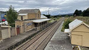
- Main Western railway: Wallerawang railway station
The Railway in Wallerawang
The Main Western railway line runs right through Wallerawang. The railway track reached Wallerawang in 1870. From May 1882, Wallerawang became a junction station. This means it was a place where two railway lines met. A new railway line to Mudgee started about 600 meters west of the station. This line was later extended and became the Gwabegar line. The railway station itself closed in the early 1990s. However, there are plans for it to open again.
Wallerawang Power Station
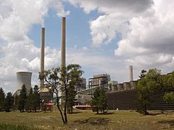
A new power station was planned in 1950. It was designed to use the type of coal found in the area. The power station was built next to the Coxs River. Construction began in November 1951, and it officially opened in 1957.
- The Wallerawang Power Station used coal to make electricity. It was on the eastern side of the town.
- The Electricity Commission of New South Wales started building it in 1951. It began making power in 1957.
- In 1978, Lake Wallace was built. This lake provided extra water to cool the power station.
- Over the years, the station was updated. It generated power for Australia's national power grid.
- The power station stopped working in 2014. It is now planned to be taken down.
Military History
Wallerawang During World War II
During World War II, Wallerawang played a small but important role. It was home to RAAF No.4 Inland Aircraft Fuel Depot (IAFD). This fuel depot was finished in 1942 and closed in 1944. These depots were built across Australia to store and supply fuel for planes. They were used by the RAAF (Royal Australian Air Force) and the US Army Air Forces.
 | Kyle Baker |
 | Joseph Yoakum |
 | Laura Wheeler Waring |
 | Henry Ossawa Tanner |


