Cox's Road and Early Deviations - Hartley, Clarence Hilly Range and Mount Blaxland Precinct facts for kids
Quick facts for kids Cox's Road and Early Deviations - Hartley, Clarence Hilly Range and Mount Blaxland Precinct |
|
|---|---|

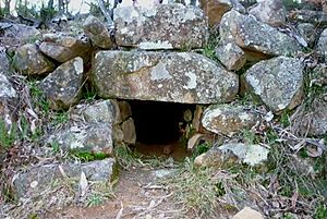
Mount Blaxland Culvert
|
|
| Location | The Old Bathurst Road, Hartley, City of Lithgow, New South Wales, Australia |
| Built | 1814–1826 |
| Architect | William Cox |
| Official name: Cox's Road and Early Deviations - Hartley, Clarence Hilly Range / Mount Blaxland Precinct; Coxs Road | |
| Type | State heritage (complex / group) |
| Designated | 25 March 2015 |
| Reference no. | 1957 |
| Type | Road |
| Category | Transport - Land |
| Builders | William Cox, Convict Road Party |
| Lua error in Module:Location_map at line 420: attempt to index field 'wikibase' (a nil value). | |
The Cox's Road and Early Deviations - Hartley, Clarence Hilly Range and Mount Blaxland Precinct is a special historic road in New South Wales, Australia. It's located near Hartley in the City of Lithgow. This road was built a long time ago, between 1814 and 1826, by a man named William Cox and a group of convicts. It's also known as Cox's Road or Coxs Road. Because of its importance, it was added to the New South Wales State Heritage Register in 2015.
Contents
Building Australia's First Mountain Road
This section tells you how and why the famous Cox's Road was built.
Why Was Cox's Road Built?
In 1813, European explorers found a way across the Blue Mountains. This opened up new lands for settlement. Governor Lachlan Macquarie wanted a proper road built. This road would connect Emu Ford (near Penrith) to Bathurst. The journey was about 101.5 kilometers (63 miles).
Who Built the Road?
The road was built by William Cox. He was a chief magistrate from Windsor. In 1814, Governor Macquarie put him in charge of building this important road. Most of the workers were convicts. They worked very hard, and many were given their freedom (pardons or "Tickets of Leave") after the road was finished.
A Quick Build: Six Months to Cross the Mountains
It's amazing, but the road was finished in just six months! This was a huge achievement back then. The Blue Mountains have always been a natural barrier. For thousands of years, Aboriginal people like the Dharug, Gundungurra, and Wiradjuri had used paths through these mountains. The new road made it easier for European settlers to move west.
Mount Blaxland's Role in the Journey
Mount Blaxland is a hill about 11 kilometers (7 miles) from Mount York. In 1813, explorers Gregory Blaxland, William Lawson, and William Charles Wentworth climbed this hill. They saw vast grasslands, which they thought could feed the colony's animals for many years. Surveyor G. W. Evans later named the hill "Mount Blaxland."
William Cox started looking for a road route near Mount Blaxland in December 1814. He found it very difficult to build a road there. The land was too hilly and rough. He wrote in his journal about how hard it was to find a good path.
Overcoming Challenges: Building the Road
Cox and his team chose a very long, steep ridge south of Mount Blaxland. They started building the road there. Within a few days, they had made good progress. They even had to remove some rocks from the path. By the end of December 1814, they had built ten small bridges over creeks between Cox's River and the Fish River.
Governor Macquarie himself traveled the new road in 1815. He described the area as "Clarence's Hilly Range," named after William, The Duke of Clarence. He even named one very steep part "Fag-Hill" because it was so tiring to climb!
When the Road Was Replaced
Over the years, small changes were made to Cox's Road to improve it. But by the late 1820s, new, better routes were being planned. Major Edmund Lockyer and then Major Thomas Mitchell found easier ways to get to Bathurst. Mitchell's new road, the Great Western Road, avoided the steep parts of Cox's Road.
Because of these new roads, the old Cox's Road "by Mount Blaxland" was used less and less. It mainly became a way for people to reach their private properties.
What Cox's Road Looks Like Today
This section describes the physical features of the historic Cox's Road.
How the Road Was Built
Governor Macquarie told William Cox to build a simple cart road. It needed to be at least 3.6 meters (12 feet) wide. This would allow two carts to pass each other. Trees were to be cleared 6 meters (20 feet) on each side. Tree stumps were to be removed, and holes filled in.
Today, you can still see parts of the original road. However, many sections were improved later, especially in the 1820s. These improvements made the road wider and more stable.
Tracing the Old Bathurst Road
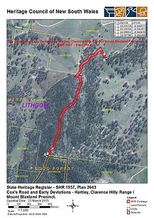
A "Crown Road" is still marked on maps in this area. It runs from McKanes Falls Road to the Rydal-Hampton Road. This is where parts of Cox's Road can be found. The actual old road sometimes goes through private land, not just along modern tracks.
You can see different types of road building here. Some parts are from Cox's original rough track. Other parts show later improvements from the 1820s. These include stone retaining walls, zig-zag paths, and stone box-culverts (small tunnels for water).
Features of the Road
As you climb a hill, the road is cut through pink granite. You can see piles of cut stone and short sections of retaining walls. The road here is about 3 meters (10 feet) wide. About 750 meters (2,460 feet) up the hill, there's a zig-zag section. This zig-zag is 140 meters (460 feet) long. It's supported by carefully built retaining walls, some up to 2 meters (6.5 feet) high.
There's also a packed stone pavement on the road. You might see piles of broken stones left over from when it was built. A simple stone box culvert, about 45 centimeters (1.5 feet) wide, is also visible. It has a rough stone top and an earthen floor.
Experts believe that many of these stone walls and wider sections were added later. They were part of upgrades to the road around 1825-1826. Cox's original road was often narrower and used simpler walls made of rough stones. The later improvements tried to make the steep slopes easier to manage.
Bridges and Creeks
Cox's journal mentioned needing many bridges in this area. Remains of an early bridge were found at Mary Anne Creek. This bridge might even be from the very first phase of road building. From Mary Anne Creek, the road goes uphill, following vehicle tracks.
The "Old Bathurst Road" then crosses the Rydal-Hampton Road. It becomes a modern local road called Cut Hill Road. While the general path is similar to Cox's Road, this modern section has been straightened and re-graded.
Condition of the Road Today
As of 2014, the road was in good condition. Many old features are still visible. These include the road surface, walls, culverts, and cuttings. You can see evidence of different periods of road building from the colonial era.
Why Cox's Road is Important (Heritage Listing)
Cox's Road is very important to the history of New South Wales. It was listed on the State Heritage Register in 2015. Here's why:
A Landmark in History
- First Road Across the Blue Mountains: It's the earliest road built by Europeans across the Blue Mountains. It was also the first structure built by Europeans west of the mountains.
- Opening Up the West: Building this road was a huge step. It showed that the natural barrier of the Blue Mountains could be conquered. It helped open up the land beyond the mountains for settlement and farming. This also sadly led to Aboriginal people losing their traditional lands.
- Symbol of Progress: The road was a symbol of Governor Macquarie's vision for the colony's growth beyond Sydney.
Connected to Key People
- Governor Lachlan Macquarie: He ordered the road to be built.
- William Cox: He was the magistrate and ex-army officer who led the building of the road. He was known for being fair to the convicts.
- Convict Workers: Many convicts worked on the road to earn their freedom.
Showing Early Road Building Skills
- Simple Techniques: The road shows how early roads were built using basic tools and skills.
- Evolution of Roads: You can see how the road was improved over time. This shows how road building techniques changed in the 1820s. The Mount Blaxland area clearly shows the difference between Cox's first rough track and the later improvements.
- Archaeological Potential: There might be more hidden parts of old bridges and drains that could be found with more archaeological work.
Important to the Community
- Community Interest: Many people, including local groups and governments, are interested in preserving Cox's Road. They want to promote it for tourism and education.
- Family Connections: The road is especially important to the descendants of William Cox.
A Source of Information
- Learning About the Past: The road helps us understand early 19th-century road building. It shows the conditions of the time and how the colony expanded.
- Engineering Achievement: It represents a big physical and engineering achievement for its time.
A Rare Example
- Unique Survival: The surviving parts of Cox's Road are rare examples of early colonial road building in New South Wales. They show how roads were built before more advanced techniques were used in the 1820s and 1830s.


