
Cox's Road and Early Deviations - Sodwalls, Fish River Descent Precinct facts for kids
Quick facts for kids Cox's Road and Early Deviations - Sodwalls, Fish River Descent Precinct |
|
|---|---|
.jpg) |
|
| Location | off Cuthill Road, Sodwalls, City of Lithgow, New South Wales, Australia |
| Built | 1814–1815 |
| Architect | William Cox |
| Official name: Cox's Road and Early Deviations - Sodwalls, Fish River Descent Precinct; Coxs Road; Old Bathurst Road | |
| Type | State heritage (complex / group) |
| Designated | 25 March 2015 |
| Reference no. | 1958 |
| Type | Road |
| Category | Transport - Land |
| Builders | William Cox; Convict Road Party |
| Lua error in Module:Location_map at line 420: attempt to index field 'wikibase' (a nil value). | |
The Cox's Road and Early Deviations - Sodwalls, Fish River Descent Precinct is a special historical area in New South Wales, Australia. It's part of an old road built a long time ago, between 1814 and 1815. This road was designed and built by a man named William Cox and a team of convicts. Today, it's a heritage-listed site, meaning it's protected because of its important history. People also call it Coxs Road or Old Bathurst Road.
Contents
Building Australia's First Mountain Road
This historic road stretched for about 163.3 kilometres (101.5 mi) from Emu Ford to Bathurst. It was built incredibly fast, in just six months! Most of the workers were convicts. Governor Lachlan Macquarie wanted a carriage road built across the Blue Mountains. This was after Europeans "discovered" new lands beyond the mountains in 1813.
A Path Through Ancient Lands
It's important to remember that the 1813 "First Crossing" happened on the traditional lands of the Dharug, Gundungurra, and Wiradjuri people. Aboriginal people had used routes through the Blue Mountains for thousands of years before Europeans arrived.
William Cox: The Road Builder
William Cox was born in England in 1764. He came to New South Wales in 1800. In 1810, he became a Chief Magistrate in Windsor. Then, in July 1814, Governor Macquarie chose him to lead the project of building the road over the Blue Mountains. Cox passed away in 1837.
The Fish River Challenge
The Cox's Road Fish River Descent Precinct is located about 8 kilometres (5.0 mi) south of Sodwalls. William Cox chose this route around December 1814. He wrote in his journal about how hilly and rocky the area was. He also mentioned needing to build bridges.
On Christmas Day, 1814, Cox and his team moved their camp to the Fish River. He gave the men a special treat and new shirts to celebrate. By early January 1815, they had finished building a strong bridge over the Fish River. Cox described it as 23 metres (75 ft) long and 4.9 metres (16 ft) wide.
The Fish River area was a very tough part of the journey. Travelers found the climb up Fish River Hill especially hard. In 1817, a botanist named Allan Cunningham said the journey was "severe and oppressive" for their horses. However, he also noted that changes were being made to make the road better.
In 1827, William Dumaresq called Fish River Hill "the worst hill from Sydney to Bathurst." He also mentioned that the old bridge had been washed away by floods. A convict road party was working there, making improvements to the road.
What the Road Looks Like Today
.jpg)
Governor Macquarie told William Cox to build a simple cart road. This was to show that the new lands in the west were open for settlement. The road was supposed to be at least 3.7 metres (12 ft) wide, so two carts could pass. Trees were to be cleared 6.1 metres (20 ft) wide on each side. Today, not many parts of the road still look exactly like these original plans.
Cut Hill Road is a modern road that follows part of the old Cox's Road. It ends at Pitt's Corner, where it meets Jerrys Meadows Road. From there, a Crown Road, also known as the Old Bathurst Road, continues towards the Fish River. This part is an unsealed road that farmers use to access their properties.
Different Road Paths
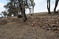
In this area, there isn't just one old road line. Experts have found three different paths. The original Cox's Road sometimes goes through private land. The oldest path is on top of a ridge. The most visible parts today are from later improvements made in the 1820s. These include long sections of stone walls that support the road as it winds down the hills.
.jpg)
The original Cox's Road followed the Crown Road that leads to "Clover Downs" and "Ambervale" farms. It looks like a widened and graded road. Closer to the Fish River, it becomes a deeply eroded track. About 1.5 kilometres (0.93 mi) east of the river, the road splits. Cox's original path goes along the ridge as a faint track and then steeply downhill. A newer section of road, built later, is cut into the side of the hills. It has a gentler slope and is supported by a large retaining wall built by convicts. This wall is between 30 centimetres (12 in) and 2 metres (6 ft 7 in) high and is made of different sized stones.
It's thought that a convict road gang, working at the Fish River in 1826, built these impressive walls. There aren't similar improvements on the western side of the river. This might be because people were already planning a completely new road to Bathurst from 1827 onwards.
Between Cox's original track and the large 1820s road, there seems to be another road. This might be the improved road that Allan Cunningham mentioned in 1817.
The Fish River Bridge
At Fish River, Cox built his second-longest bridge. It was finished on January 5, 1815. His journal says it was 4.9 metres (16 ft) wide and 23 metres (75 ft) long. Cox called it "strong and well built." However, he also noted that "floods will go over it." Today, there is no trace of this impressive bridge left. Severe floods washed it and later bridges away.
Other Parts of Cox's Road
The State Heritage Register lists six important parts, or "precincts," of Cox's Road:
- Cox's Road and Early Deviations - Linden, Linden Precinct
- Cox's Road and Early Deviations - Woodford, Old Bathurst Road Precinct
- Cox's Road and Early Deviations - Woodford, Appian Way Precinct
- Cox's Road and Early Deviations - Mount York, Cox's Pass Precinct
- Cox's Road and Early Deviations - Hartley, Clarence Hilly Range / Mount Blaxland Precinct
- Cox's Road and Early Deviations - Sodwalls, Fish River Descent Precinct
Road Condition Today
As of 2014, the road is mostly still there. You can see many features from the upgrades made in the 1820s, like retaining walls and cuttings. It's a great example of how roads were improved over time.
Why This Road is Important
.jpg)
The remaining parts of Cox's Road are very important to the history of New South Wales. It was the first road built across the Blue Mountains by Europeans. It was also the first structure built by Europeans west of the mountains.
Opening Up the West
Building this road was a huge achievement. It followed the explorations of Gregory Blaxland, William Lawson, and William Wentworth. The road showed that people could conquer the natural barrier of the Blue Mountains. It was part of Governor Macquarie's plan to expand the colony beyond Sydney. The road also led to more European settlement on Aboriginal lands.
A Chance for Convicts
William Cox was known for being fair to convicts. He could recommend pardons and tickets of leave (which gave them more freedom). Many convicts who volunteered to build this road were given their freedom when the work was done.
Learning About Old Road Building
The parts of the road that still exist show how simple and quick Cox's team had to work. You can see the techniques they used to plan, cut, and form the road. When you look at Cox's Road alongside later colonial roads, you can see how road building changed over time.
The Fish River Descent Precinct is a great example of this. You can see three different roads side-by-side. They show how a simple track grew into a more developed road. The original Cox's Road runs along the top of the ridge. Below it are newer sections, including one with a large convict-built retaining wall. This wall was likely built by a road gang in 1826.
Connecting with History
Cox's Road is important to many people today. There's a lot of interest in exploring it for tourism and education. Many community groups and governments celebrate its history. It's especially important to the descendants of William Cox.
A Window into the Past
The different parts of Cox's Road are valuable for research. They help us understand how roads, culverts, and bridges were built in the early 1800s using basic tools. The remains of the 1814-15 road show what conditions were like back then. They also help us understand early exploration and development. The road shows a major physical and engineering achievement.
A Rare Piece of History
The surviving parts of Cox's Road are rare examples of early colonial road building in New South Wales. They show how roads were built before the more advanced techniques of the 1820s and 1830s were used.
Images for kids
-
-
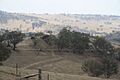
Road through the hills
-

Rocks mark the edge of the road
-
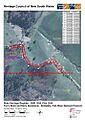
Heritage boundaries show the route of the road
