South Western Slopes
Quick facts for kids South Western SlopesNew South Wales |
|||||||||||||||
|---|---|---|---|---|---|---|---|---|---|---|---|---|---|---|---|

|
|||||||||||||||

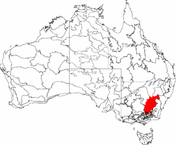
The interim Australian bioregions,
with South Western Slopes in red |
|||||||||||||||
| Area | 86,811.26 km2 (33,518.0 sq mi) | ||||||||||||||
| LGA(s) |
|
||||||||||||||
| State electorate(s) |
|
||||||||||||||
| Federal Division(s) | Eden-Monaro | ||||||||||||||
|
|||||||||||||||
The South Western Slopes is a special part of New South Wales, Australia. It's also sometimes called the South West Slopes. This region is found on the lower hills that lead away from the Great Dividing Range, which is a big mountain range. It stretches from a town called Dunedoo in the north, all the way down through central NSW, and even a little bit into Victoria near Beechworth. Most of this area, over 90%, is in New South Wales, covering about 10% of the state.
Contents
What is a Bioregion?
The South Western Slopes is known as a bioregion. A bioregion is a large area of land or water that has similar plants, animals, and ecosystems. This helps scientists study and protect nature.
This bioregion covers the lower hills of the Great Dividing Range. It goes from north of Dunedoo in NSW to northeast Victoria. It ends near Beechworth. More than 90% of this area is in New South Wales. It covers over 80,000 square kilometers.
The rivers in this bioregion are part of bigger river systems. These include the Murray, Murrumbidgee, Lachlan, and Macquarie rivers.
Parts of the Bioregion
The South Western Slopes bioregion is split into three smaller areas:
- Inland Slopes subregion (NSS01)
- Lower Slopes subregion (NSS02)
- Capertee Valley subregion (NSS03)
Climate and Weather
The weather in the South Western Slopes can change a lot. Average yearly temperatures range from cool (8°C) to warm (17°C). This depends on how high up you are and how far north or south you are.
Rainfall also varies greatly. Some areas get only 400 millimeters of rain each year. Other places, like the western side of the Snowy Mountains, can get as much as 1700 millimeters.
Snow and Seasons
Snowfalls are common on the higher hills. This happens above about 700 meters in the south. In the north, snow is common above 1100 meters. Sometimes, snow can even fall as low as Albury and Wagga Wagga. These towns are only about 165-180 meters high.
Sleet often falls in the higher parts of the region. It can also happen in lower areas, especially in the south. The most rain usually falls in winter or spring. Southern, mountainous areas get more rain in winter. Other areas get more rain in spring. Late summer to mid-autumn is usually the driest time. This period can have severe droughts.
This region has the biggest change in summer and winter temperatures in Australia. Temperatures can differ by 20°C between January (summer) and July (winter). This is because of its location near the Great Dividing Range. The weather here is more like Adelaide or Perth. These cities have wet winters and dry summers.
Weather Forecast Areas
The Bureau of Meteorology uses a smaller area for its "South West Slopes" forecast. This area is mainly between Young and Tumbarumba. The Bureau splits the larger bioregion into other forecast areas. These include the "Central West Slopes & Plains" and parts of "North East (Victoria)" and "Riverina."
Plants and Animals
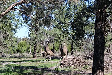
Most of the South Western Slopes is now used for growing wheat and raising sheep. Only small parts of the original plants remain. You can still find patches of woodland and large, scattered trees.
These trees include mugga ironbark, apple box, and grey box. Other types are white box, yellow box, and red box. These trees provide homes for many birds, especially parrots.
Protected Areas for Wildlife
Several nature reserves and state forests protect wildlife. These include Livingstone and Weddin Mountains National Parks. The Tarcutta Hills Reserve is also an important protected area.
Important Bird Area
A large area of 25,653 square kilometers is called the South-west Slopes of NSW Important Bird Area (IBA). This area is recognized by BirdLife International. It's important because many endangered swift parrots spend winter here. It also has the largest group of vulnerable superb parrots. Other birds like painted honeyeaters and diamond firetails also live here.
Protected Lands
The South Western Slopes of NSW have been greatly changed by human activity. Most of the native plants have been cleared. Only small, separate patches of original vegetation are left. Clearing of land still happens.
Less than 2% of this bioregion is protected as reserves. Conservation groups are working with landowners. They are trying to protect more of the land through special agreements.
National Parks
- Benambra National Park
- Conimbla National Park
- Goobang National Park
- Jindalee National Park
- Livingstone National Park
- Minjary National Park
- Nangar National Park
- Weddin Mountains National Park
- Woomargama National Park
Nature Reserves
- Avisford Nature Reserve
- Big Bush Nature Reserve
- Boginderra Hills Nature Reserve
- Buddigower Nature Reserve
- Burrinjuck Nature Reserve
- Copperhannia Nature Reserve
- Dananbilla Nature Reserve
- Dapper Nature Reserve
- Downfall Nature Reserve
- Ellerslie Nature Reserve
- Eugowra Nature Reserve
- Flagstaff Memorial Nature Reserve
- Ingalba Nature Reserve
- Koorawatha Nature Reserve
- Mudjarn Nature Reserve
- Mullengandra Nature Reserve
- Munghorn Gap Nature Reserve
- Narrandera Nature Reserve
- Nest Hill Nature Reserve
- Pucawan Nature Reserve
- Razorback Nature Reserve
- Tabletop Nature Reserve
- The Charcoal Tank Nature Reserve
- The Rock Nature Reserve
- Ulandra Nature Reserve
- Wiesners Swamp Nature Reserve
Historic Sites
- Hill End Historic Site
- Yuranighs Aboriginal Grave Historic Site
Human Settlement
The Wiradjuri people were the first inhabitants of the South Western Slopes. They are the largest Aboriginal language group in New South Wales.
Many towns and cities are found in this bioregion. They stretch from Beechworth in the southwest to Dunedoo in the northeast. Some of these towns include Wodonga, Albury, Wagga Wagga, Young, and Mudgee.
Other towns like Griffith and Orange are just outside the bioregion's edges.
Local Government Areas
Several local government areas are part of this bioregion. These are councils that manage local services. They include:
- Mid-Western Regional Council (including Mudgee)
- Dubbo Regional Council
- City of Wagga Wagga
- City of Albury
- Snowy Valleys Council
- Shire of Towong (in Victoria)
See also
 In Spanish: Laderas del Suroeste para niños

