
Gippsland facts for kids
Quick facts for kids Gippsland RegionVictoria |
|||||||||||||||
|---|---|---|---|---|---|---|---|---|---|---|---|---|---|---|---|

John Longstaff's Gippsland, Sunday night, 20 February 1898, depicting the "Red Tuesday" bushfires that ravaged Gippsland
|
|||||||||||||||

Waterfront at Port Albert.
|
|||||||||||||||

Gippsland Region
Location in Victoria
|
|||||||||||||||
| Population | 271,266 (2016 census) | ||||||||||||||
| • Density | 6.52772/km2 (16.9067/sq mi) | ||||||||||||||
| Area | 41,556 km2 (16,044.9 sq mi) | ||||||||||||||
| Time zone | AEST (UTC+10) | ||||||||||||||
| • Summer (DST) | AEDT (UTC+11) | ||||||||||||||
| Location | 120 km (75 mi) E of Melbourne | ||||||||||||||
| LGA(s) |
|
||||||||||||||
| State electorate(s) |
|
||||||||||||||
| Federal Division(s) | |||||||||||||||
|
|||||||||||||||
Gippsland is a large rural region in the southeastern part of Victoria, Australia. It covers about 41,556 square kilometers (16,045 sq mi). This area is mostly made up of flat coastal lands. These lands are located south of the Victorian Alps, which are part of the Great Dividing Range.
Gippsland is located east of Melbourne's outer suburbs. It stretches between the Dandenong Ranges and the Mornington Peninsula. To the north, it's bordered by mountains and highlands. These separate it from the Hume region. To the southwest, you'll find the Western Port Bay. The Bass Strait and the Tasman Sea are to the south and east. The Black-Allan Line forms the border with New South Wales to the east and northeast.
The region is generally divided into five main areas. These are West Gippsland, South Gippsland, Latrobe Valley, Central Gippsland, and East Gippsland. In 2016, Gippsland had a population of about 271,266 people. The biggest towns include Traralgon, Moe, Warragul, and Morwell. Gippsland is well-known for its main industries. These include mining, making electricity, and farming. It's also a popular place for tourists. Famous spots are Phillip Island, Wilsons Promontory, and the Gippsland Lakes.
Contents
History of Gippsland
First Peoples and Early Explorers
The original owners of the Gippsland land are the Indigenous Australian people. These include the Gunai nation and, in West Gippsland, the Bunurong nation. Before Europeans settled here, seal hunters and people gathering wattle bark visited the area. But they did not stay permanently.
In 1835, Samuel Anderson started a farm settlement. This was on the Bass River in Gippsland. It was one of the first permanent European settlements in Victoria. His business partner, Robert Massie, joined him later. Samuel's brothers, Hugh and Thomas, also came to Bass. They helped make the farm very successful.
Naming the Region
More European exploration happened after these first settlements. In 1840, a Polish explorer named Paweł Edmund Strzelecki led an expedition. He traveled through the country of the Gunai people. He gave new names to many natural places. Strzelecki named the region "Gippsland." He did this to honor George Gipps, who was the Governor of New South Wales and his sponsor.
Another explorer, Angus McMillan, also led an expedition in 1840. He called the Gunai country "Caledonia Australis." However, the name "Gippsland" given by Strzelecki was the one that stuck. The town of Bass was officially set up in the early 1860s. More intense settlement of South Gippsland began in the late 1870s.
Geography of Gippsland
|

Gippsland is divided into four or five main areas:
- West Gippsland: This area is similar to the Baw Baw Shire.
- South Gippsland: This includes the Bass Coast and South Gippsland Shires.
- The Latrobe Valley: This covers Latrobe City and parts of Baw Baw to the north.
- East Gippsland: This includes the Shires of Wellington and East Gippsland.
- Sometimes, a fifth area called Central Gippsland is mentioned. This drier area is between the Gippsland Lakes and Yarram.
Climate and Weather

Gippsland has a mild climate. It is usually humid, meaning there's a lot of moisture in the air. The central area around Sale is an exception, with less rain. In the Strzelecki Ranges, it can rain a lot, up to 1,500 mm (59 inches) each year. The high mountains of East Gippsland also get a lot of rain, often as snow.
In lower areas east of the Snowy River, the average yearly rainfall is about 900–950 mm (35–37 inches). Summer temperatures in lower areas reach about 24°C (75°F) in January. Winter temperatures in July are around 15°C (59°F). In the highlands, like the Baw Baw Plateau, temperatures are cooler. Winter can bring heavy snowfalls, sometimes cutting off areas like the Errinundra Plateau.
Natural Resources

Gippsland's soils are generally not very fertile. They often lack important nutrients like nitrogen and phosphorus. This means farmers need to add a lot of fertilizer to grow crops. Despite this, some parts of Gippsland are very good for dairy farming and growing vegetables. The region supplies Melbourne with most of its dairy and vegetable needs.
A few areas, especially near the Snowy River, have naturally fertile soils. These areas have always been farmed a lot. In the far northeast, there's a small part of the Monaro Tableland used for raising beef cattle.
Gippsland doesn't have many metal minerals. Gold rushes in the 1800s around Foster and Buchan didn't last long. However, there were deep underground gold mines at Walhalla that operated for 50 years. Gippsland is famous for having the world's largest deposits of brown coal. Also, around Sale and offshore in the Bass Strait, there are large amounts of oil and natural gas.
The seas around Gippsland don't have a lot of fish. This is because there isn't much upwelling, which brings cold, nutrient-rich water to the surface. But towns like Marlo and Mallacoota used to rely on fishing for abalone. Abalone shells were very valuable for their pearls and for making decorative inlays.
How Gippsland is Governed
Political Representation
For Australian federal elections, parts of Gippsland are in the electoral divisions of Flinders, Monash, and Gippsland. These divisions are represented by members of Parliament.
For Victorian state elections, parts of Gippsland are in the electoral districts of Bass, Narracan, Morwell, Gippsland South, and Gippsland East. These districts also have their own elected representatives.
Local Government Areas
Gippsland has six main local government areas. These are like local councils that manage services for their communities. They include:
- Bass Coast Shire
- Shire of Baw Baw
- Shire of East Gippsland
- Latrobe City
- South Gippsland Shire
- Shire of Wellington
Protecting the Environment
Gippsland is home to many important national parks. These parks help protect the natural environment and wildlife. Some of these parks include:
- Alfred National Park
- Baw Baw National Park
- Coopracambra National Park
- Croajingolong National Park
- Errinundra National Park
- Gippsland Lakes Coastal Park
- Lind National Park
- Mitchell River National Park
- Morwell National Park
- Snowy River National Park
- Tarra-Bulga National Park
- The Lakes National Park
- Wilsons Promontory National Park
There are also large areas of State forest. These forests also help protect nature and its many creatures.
Images for kids
-
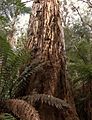
Old growth forests in East Gippsland
-
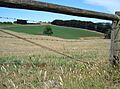
Potato farming in the Thorpdale region
See also
 In Spanish: Gippsland para niños
