Western Port facts for kids
Quick facts for kids Western Port |
|
|---|---|
| Western Port Bay | |
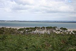
Western Port from French Island.
|
|
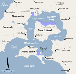
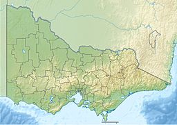
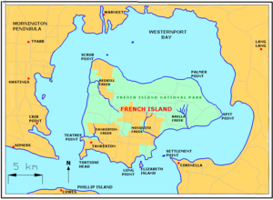
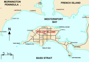
Map of Western Port
|
|
| Location | Southern Victoria |
| Coordinates | 38°22′S 145°20′E / 38.367°S 145.333°E |
| Type | Saline, Permanent, Natural |
| Primary inflows | Bunyip River, Lang Lang River, Bass River, Cardinia Creek |
| Primary outflows | Bass Strait |
| Basin countries | Australia |
| Max. length | 263 km (163 mi) |
| Surface area | 680 km2 (260 sq mi) |
| Average depth | 6 m (20 ft) |
| Max. depth | 25 m (82 ft) |
| Surface elevation | 0 m (0 ft) |
| Frozen | never |
| Islands | Phillip Island, French Island, Quail Island, Churchill Island |
| Settlements | Hastings, Tooradin, San Remo, Cowes |
| Designated: | 15 December 1982 |
| Reference #: | 267 |
Western Port, also known as Western Port Bay, is a large bay in southern Victoria, Australia. It opens into Bass Strait and is the second biggest bay in the state. Even though it's called "Western Port," it's actually to the east of the larger Port Phillip. The Mornington Peninsula separates the two bays.
Western Port is famous for its two big islands: French Island and Phillip Island. Many amazing animals visit the bay, including Australian fur seals, whales, and dolphins. Lots of migratory waders and seabirds also come here. Because it's so important for wildlife, it's listed as a special wetland under the Ramsar Convention.
Before Europeans arrived, the Boonwurrung people lived around the bay. Europeans first saw Western Port in 1798. An explorer named George Bass led a crew in a whaleboat from Sydney. They explored Australia's southeastern coast. They spent two weeks in Western Port before heading back to Sydney. It was named "Western Port" because it was the most westerly point they had explored at the time.
Today, Western Port is home to three Marine National Parks: French Island, Churchill Island, and Yaringa. The land nearby is used for farming. People mostly use the bay for fun activities like boating. There's also a naval base (HMAS Cerberus), shipping, and oil facilities. Western Port is about an hour's drive from Melbourne. You can find holiday villages with sandy beaches along its shores.
Contents
Exploring Western Port's Past
Before European settlers came, the Bunurong people lived around Western Port. They found food like shellfish, mutton birds, and plants. In 1797, George Bass was given permission to explore the coast south of Botany Bay. He sailed in a whaleboat and discovered Western Port. He named it "Western Port" because it was the most western harbor known at that time. This was even though it's east of Port Phillip and Melbourne. In the 1800s, people also hunted seals here.
Early European Settlements
In 1826, the British government heard that the French might try to settle in an Australian harbor. So, they quickly sent a group from Sydney to Western Port. This group included soldiers and convicts. They landed at Settlement Point, near where Corinella is today. However, after about a year, the settlement was closed because it was not seen as a good place for a colony.
Later, in 1835, Samuel Anderson started a lasting European settlement in Bass. This was one of the first permanent settlements in Victoria. After World War II, people started to develop the port more seriously. Now, the northern shores of the bay have become a place for big industries.
Geography and Islands of Western Port
Western Port was once a large river system. The sea rose during the Holocene period and flooded it, creating the big tidal bay we see today. The bay covers an area of 680 square kilometers. About 270 square kilometers of this area become mud flats when the tide is low.
The bay has two very large islands: French Island and Phillip Island. The coastline, including the islands, is about 263 kilometers long. The bay and its islands have seven active fault lines. This means they experience many small earthquakes each year.
In the northern part of the bay, several rivers and creeks flow in. They pass through thick mangrove forests, mudflats, and sand banks. These waters then flow around French Island and out into the open sea near Phillip Island. Some main rivers that flow into Western Port are the Bunyip River, Lang Lang River, Bass River, and Cardinia Creek.
Until the mid-1900s, a huge swamp called the Koo-Wee-Rup Swamp was next to the bay in the north. It was a very large area. Today, the mangroves in the northern bay are what's left of this swamp.
Islands You Can Explore
Western Port has two large islands and many smaller ones. Here are some of them:
- French Island - This island is 170 square kilometers. About 116 people live here.
- Phillip Island - This island is 100 square kilometers. About 9,000 people live here.
- Middle Spit - This area is exposed when the tide is low.
- Quail Island
- Tortoise Head Bank - Also exposed at low tide.
- Churchill Island - This island is 57 hectares.
- Chinaman Island
- Elizabeth Island
- Sandstone Island
- Reef Island
- Long Island
- Schnapper Rock
- Pelican Island
- Barrallier Island
- Ram Island
- Joe Island
Amazing Wildlife and Nature
Plants and Habitats
Western Port has many different types of natural areas. These include seagrass beds under the water, rocky areas exposed at low tide, sandy beaches, mudflats, and tidal channels. There are also saltmarshes and mangroves. The coastline around Phillip Island is very special because it has rare coastal grasslands and dune scrub. These plant communities are not common in Victoria.
Animals of the Bay
Western Port is home to many different invertebrates like sponges and corals. The mudflats and mangrove swamps in the northern part of the bay have lots of invertebrates. These small creatures are an important food source for waders and migratory birds. French Island is a home for migratory waders, Australian pelicans, and many other important animals.
The bay is recognized as an Important Bird Area (IBA). This means it's a very important place for birds. It supports small numbers of the critically endangered orange-bellied parrot. It also hosts over 1% of the world's populations of Far Eastern curlews, red-necked stints, and pied oystercatchers. You can also find vulnerable fairy terns here.
The Phillip Island Penguin Reserve has the largest group of little penguins in Victoria. It also has a big colony of short-tailed shearwaters. You can see breeding hooded plovers and peregrine falcons here too. Seal Rock, off Phillip Island, is where the largest group of Australian fur seals lives. It's also a breeding spot for kelp gulls and sooty oystercatchers. The marine life near San Remo is very rich and protected by law.
Western Port is listed under the Ramsar Convention because its wetlands are important worldwide. The Moonlit Sanctuary Wildlife Conservation Park in Pearcedale lets you see some of the native mammals and birds of the area up close.
In recent years, more whales have been seen in the bay, mostly southern right and humpback whales. Local groups are studying their presence and ask people to report any sightings.
Parks and Protected Areas
Western Port has several important parks and protected areas, both on land and in the water.
- Land Parks:
- Coolart Wetlands and Homestead Reserve
- French Island National Park
- Langwarrin Flora and Fauna Reserve
- Mornington Peninsula National Park
- Marine Parks:
- French Island National Park - This marine park covers 2,800 hectares.
- Yaringa Marine National Park - This marine park covers 980 hectares.
- Churchill Island Marine National Park - This marine park covers 670 hectares.
Fun Things to Do at Western Port
Western Port is a great place for outdoor activities. Fishing, pleasure boating, and yachting are very popular.
Things to Do on Phillip Island
- Penguin Reserve - Visit at dusk to watch the penguins return to their burrows.
- Seal Rocks - You can view seals through binoculars.
- Koala Conservation Centre - See koalas in their natural habitat.
- Bird watching - Spot many different bird species.
- Scenic Flights - Take a flight from Phillip Island Airport to see the bay from above.
Things to Do on French Island
- Bushwalking or bird observing - Explore the island's trails and look for birds.
- Bush orchid and fishing areas - Discover beautiful orchids and find good fishing spots.
- Horse riding and bike rides - Enjoy the island on horseback or bicycle.
- Deep water fishing - Go fishing in the deeper parts of the bay.
- Koala habitat - French Island is home to many koalas.
- Camping - Spend a night under the stars.
Boating and Shipping in the Bay
Deep channels from Bass Strait lead into the western part of the bay. These channels allow ships to reach the port facilities. The town of Hastings is the main boat landing spot. The Yaringa Marina at Somerville also has boat harbor facilities.
There are many places to launch your boat:
- Stony Point - Has a concrete 3-lane ramp and 2 jetties. Good for all tides.
- Blind Bight - Has a single tarmac ramp and a jetty. Best at high tide.
- Corinella - Has a concrete 2-lane ramp and 2 jetties. Good for all tides.
- Hastings - Has a concrete 4-lane ramp and a jetty. Good for all tides.
There are also ramps at Tooradin, Newhaven, Cowes, Warneet, Lang Lang, Grantville, Flinders, and Rhyll (Phillip Island).
A ferry runs between Cowes, Tankerton, and Stony Point at certain times of the year. You can check the timetable at these locations. Accommodation is available on both Phillip Island and French Island.
Industries Around Western Port
Western Port has several industrial areas. These include a BlueScope steel processing plant. It also has HMAS Cerberus, which is a major training base for the Royal Australian Navy. Holden Australia's testing ground is just east of Western Port.
There are plans to make the Port at Hastings a main shipping port for containers and freight in Victoria. However, many local groups are against this. They worry about how big the development would be and its effect on the bay's delicate environment.
Protecting the Bay's Environment
To protect the marine environment, some activities are not allowed in Victoria's Marine National Parks and Marine Sanctuaries. You cannot fish, net, spear, or kill any marine life. All types of fishing, from the shore or a boat, are forbidden. You also cannot take or damage animals, plants, or historical items. There are serious penalties for fishing in these protected areas. You can report any violations to the Department of Primary Industries.
However, you can carry fish on your boat if you caught them outside the park. You can also carry a fishing rod or spear gun, but you cannot use them inside the park. You may also have equipment for abalone or rock lobster on board. But you must be traveling directly through the park by the shortest route possible.
See also
 In Spanish: Bahía de Western Port para niños
 | Dorothy Vaughan |
 | Charles Henry Turner |
 | Hildrus Poindexter |
 | Henry Cecil McBay |


