Phillip Island facts for kids
|
Native name:
Corriong/Worne/Millowl
|
|
|---|---|
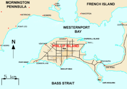
Map of Phillip Island
|
|
| Geography | |
| Location | Western Port |
| Coordinates | 38°29′S 145°14′E / 38.483°S 145.233°E |
| Area | 101 km2 (39 sq mi) |
| Length | 26 km (16.2 mi) |
| Width | 9 km (5.6 mi) |
| Coastline | 97 km (60.3 mi) |
| Highest elevation | 110 m (360 ft) |
| Administration | |
|
Australia
|
|
| State | Victoria |
| LGA | Bass Coast Shire |
| Largest settlement | Cowes (pop. 6593) |
| Demographics | |
| Population | 13,799 (2021) |
| Pop. density | 137.03 /km2 (354.91 /sq mi) |
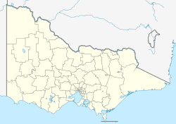
Phillip Island is an Australian island about 125 kilometers (78 miles) south-east of Melbourne, Victoria. The local Boonwurrung people call it Corriong, Worne, or Millowl. The island got its English name from Governor Arthur Phillip, who was the first Governor of New South Wales. Explorer George Bass named it in 1798.
Phillip Island acts like a natural wall for the shallow waters of Western Port. It is 26 kilometers (16 miles) long and 9 kilometers (5.6 miles) wide. Its total area is about 101 square kilometers (39 square miles). The island has 97 kilometers (60 miles) of coastline and is part of the Bass Coast Shire.
A 640-meter (2,100-foot) concrete bridge connects the island town of Newhaven to the mainland town of San Remo. In 2021, about 13,799 people lived on the island all year. This number grows to 40,000 during the summer holidays! About 60% of the island is farmland, used for raising sheep and cattle.
UNESCO officially recognizes Phillip Island as part of the Mornington Peninsula and Western Port Biosphere Reserve. This means it's a special place where nature is protected, and people work together to live in a way that helps the environment.
Contents
History of Phillip Island
The first people to live in this area were the Yalloc Bulluk clan of the Bunurong people. They are part of the Kulin nation. In their language, the island is known as corriong or millowl. Because they lived near the coast with its safe bays, the Bunurong people were some of the first Aboriginal people in Victoria to meet European sailors.
After explorers George Bass and Matthew Flinders visited in 1798, seal hunters from Van Diemen's Land often came to the area. They sometimes had conflicts with the Bunurong people. In 1801, a navigator named James Grant visited nearby Churchill Island and planted crops there.
In 1826, a French scientific trip led by Dumont d'Urville made the British worried. They thought the French might try to start a colony in Western Port. So, the British sent ships from Sydney to check.
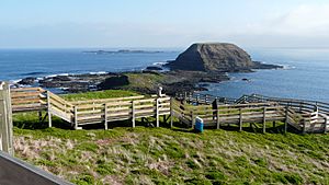
The French did not start a colony. But the British captain, Wetherall, found a seal hunter's camp and some planted crops. A small fort was built near Rhyll. People noted that the island had plenty of wood, good soil, and even coal at Cape Woolamai. Wetherall also put up a flag on a flat-topped rock called The Nobbies. This helped ships find the harbor entrance.
Captain Wetherall said the local people seemed to be many. But they would run into the woods when his group came near. He made sure his men did not chase or bother them. The only problem Wetherall found was the island's water supply. He dug a well, but it did not have enough water for ships. This led to the British moving their settlement to the mainland.
Later, in 1839, explorers found water by digging near some bushes. In 1840, it was confirmed that water could be found near the best place to anchor ships.
In 1835, Samuel Anderson started a settlement on the mainland across from Phillip Island. In 1841, brothers John David and William McHaffie were given Phillip Island to use for farming. They brought animals like pheasants, deer, and wallabies to the island.
Plans for the first bridge to the island began in 1938. It cost £50,000 and opened in November 1940. The island had a public holiday to celebrate!
In 2018, Phillip Island celebrated its 150th birthday. Many events took place, including a community parade. The Phillip Island & District Historical Society keeps records of the island's history.
Environment and Wildlife
The Phillip Island Nature Parks group helps protect nature and offers eco-friendly tourism on the island.
The southern and western coasts of the island are an Phillip Island Important Bird Area. This means it's very important for birds. Many little penguins, short-tailed shearwaters, and Pacific gulls live here. In 2023, there were about 40,000 little penguins on the island. They live on the Summerland Peninsula, which is a wildlife reserve.
When many penguins died in a heatwave, native plants were put around their homes to keep them cool. Grass fires are also a threat to penguins. A project is working to replace plants that burn easily with native plants that are safer. These plants create natural firebreaks.
The island's penguins were also in danger from foxes. After most foxes were removed in 2017, the number of rabbits grew. Rabbits can cause soil to wash away and harm native plants. Conservationists now use gas to control the rabbits.
There is also a wildlife park where wallabies and kangaroos walk freely. Visitors can feed them by hand. Seal Rocks, at the west end of the island, has Australia's largest group of fur seals. Up to 16,000 seals lived there around 2008.
In recent years, southern right whales and humpback whales have started to return to the area. They use the waters around Phillip Island as a place to have their babies. People hope to start whale watching tours soon. The local critically endangered Burrunan dolphins also live here.
The Eastern barred bandicoot is a small marsupial. It is similar in size to a rabbit. These animals are being brought back to Phillip Island to help their numbers grow.
Climate
Phillip Island has an oceanic climate. This means it has mild, wet winters and warm, drier summers. The island's weather is milder than Melbourne's because of winds from the Bass Strait.
The average high temperature is about 23.8°C (74.8°F) in February and 13.5°C (56.3°F) in July. The average low temperature is about 14.0°C (57.2°F) in February and 6.8°C (44.2°F) in July. It rains often, especially in winter. The island gets about 738.1 mm (29 inches) of rain each year.
The Phillip Island Grand Prix motorcycle race is usually in October. The weather can be tricky then, with cold temperatures and strong winds. Snow was even seen on the island on August 10, 2005, which is very rare!
| Climate data for Phillip Island (38°31′S 145°09′E / 38.51°S 145.15°E, 7 m AMSL) (1981-2018 normals & extremes) | |||||||||||||
|---|---|---|---|---|---|---|---|---|---|---|---|---|---|
| Month | Jan | Feb | Mar | Apr | May | Jun | Jul | Aug | Sep | Oct | Nov | Dec | Year |
| Record high °C (°F) | 41.5 (106.7) |
39.2 (102.6) |
37.2 (99.0) |
33.0 (91.4) |
25.1 (77.2) |
21.8 (71.2) |
21.8 (71.2) |
23.8 (74.8) |
27.8 (82.0) |
30.9 (87.6) |
34.2 (93.6) |
39.2 (102.6) |
41.5 (106.7) |
| Mean daily maximum °C (°F) | 23.7 (74.7) |
23.8 (74.8) |
22.3 (72.1) |
19.8 (67.6) |
16.8 (62.2) |
14.4 (57.9) |
13.5 (56.3) |
14.5 (58.1) |
16.1 (61.0) |
17.8 (64.0) |
19.8 (67.6) |
21.9 (71.4) |
18.7 (65.6) |
| Mean daily minimum °C (°F) | 13.9 (57.0) |
14.0 (57.2) |
12.9 (55.2) |
10.6 (51.1) |
8.9 (48.0) |
7.5 (45.5) |
6.8 (44.2) |
7.3 (45.1) |
8.3 (46.9) |
9.1 (48.4) |
10.5 (50.9) |
12.1 (53.8) |
10.2 (50.3) |
| Record low °C (°F) | 4.0 (39.2) |
4.4 (39.9) |
1.6 (34.9) |
0.7 (33.3) |
−0.2 (31.6) |
−1.5 (29.3) |
−2.3 (27.9) |
−2.0 (28.4) |
−1.0 (30.2) |
0.6 (33.1) |
0.5 (32.9) |
1.7 (35.1) |
−2.3 (27.9) |
| Average precipitation mm (inches) | 33.4 (1.31) |
34.0 (1.34) |
49.4 (1.94) |
63.1 (2.48) |
70.0 (2.76) |
78.2 (3.08) |
76.9 (3.03) |
79.7 (3.14) |
69.5 (2.74) |
66.9 (2.63) |
60.0 (2.36) |
48.9 (1.93) |
738.1 (29.06) |
| Average precipitation days (≥ 0.2 mm) | 7.8 | 6.8 | 9.5 | 12.5 | 13.9 | 15.3 | 17.6 | 17.7 | 15.9 | 13.8 | 11.4 | 9.2 | 151.4 |
| Average afternoon relative humidity (%) | 67 | 67 | 67 | 69 | 76 | 78 | 76 | 73 | 71 | 69 | 69 | 68 | 71 |
| Average dew point °C (°F) | 13.8 (56.8) |
14.8 (58.6) |
13.6 (56.5) |
11.8 (53.2) |
10.6 (51.1) |
9.4 (48.9) |
8.1 (46.6) |
8.2 (46.8) |
8.8 (47.8) |
9.9 (49.8) |
11.5 (52.7) |
12.6 (54.7) |
11.1 (52.0) |
| Source: Bureau of Meteorology (1981-2018 normals & extremes) | |||||||||||||
Tourism on Phillip Island
Phillip Island is a very popular place for tourists. About 3.5 million people visit each year. The island is home to around 40,000 penguins, making it the world's largest penguin colony.
The Penguin Parade at Phillip Island Nature Park is a big attraction. Here, little penguins come ashore in groups after a day of fishing. Visitors come from all over the world to see them. Remember, taking photos is not allowed to keep the birds safe.
The Nobbies Centre is another great place to visit. It's at the western tip of the island. From here, you can walk on boardwalks to see the seal colony, The Nobbies rocks, and The Blowhole.
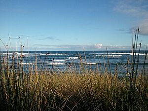
Phillip Island is also famous for its great surfing conditions. It's one of the best surfing spots in Australia. In 2013, Victoria's first National Surfing Reserve was created here. It includes four main surfing areas: Woolamai, Smiths Beach, Summerlands, and Cat Bay. Phillip Island hosts big surfing events, like the World Surfing League – Phillip Island Pro.
From May to September each year, you can often see whales migrating along the coast. Humpback whales, southern right whales, and sometimes killer whales pass by Phillip Island. Other events include the Churchill Island Working Horse and Pioneer Festival.
The National Vietnam Veterans Museum was started by volunteer veterans. It has a unique collection of items, vehicles, and memories from the Vietnam War. It helps support veterans and shares their stories.
Motorsport History
Phillip Island has a rich history in Australian motor racing. The first Australian Grand Prix was held here in 1928. It used public roads on the island as a temporary track. Races continued on these roads until 1940.
In 1952, the Phillip Island Auto Racing Club built a permanent track. The Phillip Island Grand Prix Circuit opened in 1956. In 1960, the first Armstrong 500 race was held here. However, the bridge to the mainland could not support heavy equipment. This meant the track broke up during the 1962 race. The damage made the circuit unusable. So, in 1963, the Armstrong 500 moved to another track. This race later became known as the Bathurst 1000.
The circuit was fixed up and reopened in 1967. It closed again in 1978 but was rebuilt and reopened in 1988. The next year, it hosted the first international Australian motorcycle Grand Prix. Today, it still hosts this race, along with other major events like the Superbike World Championship and the MotoGP Championship.
Phillip Island in the Media
Phillip Island has appeared in many books, poems, documentaries, and Hollywood films. It is known for its beautiful coast and the Penguin Parade. The island has been a setting in Australian stories, TV shows, and nature documentaries. Its amazing landscapes have also been used in international movies and TV.
A famous example is the 1959 film On the Beach. Famous actors like Fred Astere, Gregory Peck, Ava Gardner, and Anthony Perkins came to Phillip Island to film scenes at the Grand Prix Circuit.
Films
- On the Beach (1959)
- Summerfield (1977)
- The Hands of Cormac Joyce (1972)
Documentary Films
- Martin Clunes: Islands of Australia (2016)
- Penguin Island (2010) by BBC
Short Films
- Mermaid homesick (2016)
- Spotwind (2020)
- Severance Bay (2023)
Books
- Phillip Island and Western Port (1989) by Jean Edgecombe
- The Facing Island (2003) by Jan Bassett
- Phillip Island: A history of motorsport since 1928 (2005) by Jim Scraysbrook
- Islands of Australia (2009) by Marc Fiddian
- 500 Million years on Phillip Island (2021) by Linda Cuttriss and Eric Bird
- Once upon an Island: The early days of Phillip Island (2023)
- The Littlest Penguin and the Phillip Island Penguin Parade (2023) by Jedda Robbard
- Phillip Island: The inside story of Australia's fastest racetrack, our home of motorsport (2024) by John Smailes
Localities
Towns on the island include:
- Cape Woolamai
- Cowes
- Newhaven
- Rhyll
- Silverleaves
- Smiths Beach
- Summerlands
- Sunderland Bay
- Surf Beach
- Ventnor
- Wimbledon Heights
Notable Residents
- William Watt, politician
- Frank Sedgman, tennis player
- Alan Jackson, business executive
- Graeme Strachan, singer
- Manning Clark, historian
- Chris Hemsworth, actor
- Liam Hemsworth, actor
- Luke Hemsworth, actor
- Nikki van Dijk, professional surfer
- Sam Docherty, AFL footballer
See also
 In Spanish: Isla Phillip para niños
 | Charles R. Drew |
 | Benjamin Banneker |
 | Jane C. Wright |
 | Roger Arliner Young |


