Mount Baw Baw facts for kids
Quick facts for kids Mount Baw Baw |
|
|---|---|

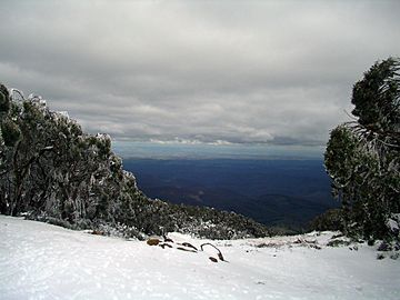
The view south across Gippsland from Mount Baw Baw
|
|
| Highest point | |
| Elevation | 1,567 metres (5,141 ft) AHD |
| Geography | |
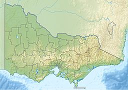
| Location | Victoria, Australia |
| Parent range | Baw Baw Plateau, Great Dividing Range |
| Climbing | |
| Easiest route | Hike/ski |
Mount Baw Baw is a mountain located in Victoria, Australia. It's part of the Baw Baw Plateau and the Great Dividing Range. The top of the mountain is inside the Mount Baw Baw Alpine Resort. This resort is a special area in Victoria, separate from the local government area called the Shire of Baw Baw. The name 'Baw Baw' comes from an old word used by the Eastern Kulin people, but its exact meaning is not known today.
Contents
Where is Mount Baw Baw Located?
Mount Baw Baw is about 120 kilometers (75 miles) east of Melbourne. It's also about 50 kilometers (31 miles) north of the Latrobe Valley. This mountain is one of several peaks on the Baw Baw Plateau. This plateau is a long, flat-topped area that stretches towards the north-east.
Other peaks on the plateau include Mount Mueller, Mount Whitelaw, and Mount St Gwinear. Rivers like the Thomson and Aberfeldy surround the plateau. This makes it quite separate from other high mountain areas in Victoria.
Nature and Wildlife at Mount Baw Baw
The Baw Baw area is made of a type of rock called granodiorite. The plateau itself is mostly flat, with its highest point reaching 1,567 meters (5,141 feet). The lower parts of the plateau are covered in thick forests. These include montane eucalypt forests and tall forests.
In creek valleys, you can find cool temperate rainforests. These forests have trees like myrtle beech. Above 1,200 meters (3,900 feet), you'll see snow gum woodlands. There isn't a clear tree line where trees stop growing. Instead, open grasslands and shrublands appear in flat valleys. This happens because cold air settles there.
Much of this high-altitude area is part of the 133 square kilometer (51 square mile) Baw Baw National Park. The Baw Baw Village ski resort is just outside the national park's boundaries.
The climate on the plateau is subalpine, meaning it's like a mountain climate. It gets about 1,900 millimeters (75 inches) of rain each year. Snow usually covers the plateau from June to September.
It's believed that Baron Ferdinand von Mueller was the first European to climb Mount Baw Baw in 1860. He named Christmas Creek during one of his trips to collect plants. On this trip, he found the Baw Baw Berry, a plant called Wittsteinia vacciniacea.
There are two main roads to get up the mountain. One is through Noojee and Icy Creek, which is very winding. The other is the unsealed South Face Road, which goes through Erica.
Mount Baw Baw is also home to a very special animal. It's called the Baw Baw frog, and it is critically endangered. This means it's at a very high risk of disappearing forever.
Mount Baw Baw's Climate
Mount Baw Baw has a cool, wet climate, often called a subpolar oceanic climate. The mountain top gets a lot of rain and snow each year. In winter, there's often heavy snow, and the ground stays covered for a long time.
During winter, it's often cloudy and windy. This means that the lowest temperatures rarely drop below -5°C (23°F). The highest temperatures are often at or below 0°C (32°F). The mountain is frequently covered in low clouds or mist in winter.
Summers are cool, with temperatures rarely going above 25°C (77°F). Sometimes, summers can be very cold. For example, on Christmas Day in 2006, the highest temperature was only -0.4°C (31.3°F). Even during a big heatwave in 2009, when most of Victoria was over 45°C (113°F), Mount Baw Baw's peak only reached 31.3°C (88.3°F).
| Climate data for Mount Baw Baw (1997–2020); 1,561 m AMSL; 37° 50′ 17.88″ S | |||||||||||||
|---|---|---|---|---|---|---|---|---|---|---|---|---|---|
| Month | Jan | Feb | Mar | Apr | May | Jun | Jul | Aug | Sep | Oct | Nov | Dec | Year |
| Record high °C (°F) | 30.9 (87.6) |
31.3 (88.3) |
26.2 (79.2) |
20.6 (69.1) |
16.2 (61.2) |
12.6 (54.7) |
10.0 (50.0) |
13.1 (55.6) |
16.6 (61.9) |
21.2 (70.2) |
26.0 (78.8) |
27.7 (81.9) |
31.3 (88.3) |
| Mean daily maximum °C (°F) | 17.6 (63.7) |
16.7 (62.1) |
14.0 (57.2) |
9.9 (49.8) |
6.4 (43.5) |
3.5 (38.3) |
2.2 (36.0) |
2.9 (37.2) |
5.6 (42.1) |
9.0 (48.2) |
12.4 (54.3) |
14.7 (58.5) |
9.6 (49.2) |
| Mean daily minimum °C (°F) | 8.7 (47.7) |
8.2 (46.8) |
6.3 (43.3) |
3.8 (38.8) |
1.5 (34.7) |
−0.5 (31.1) |
−1.6 (29.1) |
−1.6 (29.1) |
−0.2 (31.6) |
1.7 (35.1) |
4.3 (39.7) |
6.0 (42.8) |
3.0 (37.5) |
| Record low °C (°F) | −2.0 (28.4) |
−1.0 (30.2) |
−2.2 (28.0) |
−5.7 (21.7) |
−5.0 (23.0) |
−7.0 (19.4) |
−6.6 (20.1) |
−8.5 (16.7) |
−6.3 (20.7) |
−6.4 (20.5) |
−4.5 (23.9) |
−3.1 (26.4) |
−8.5 (16.7) |
| Average precipitation mm (inches) | 91.9 (3.62) |
99.1 (3.90) |
99.1 (3.90) |
140.1 (5.52) |
124.7 (4.91) |
138.9 (5.47) |
162.9 (6.41) |
174.4 (6.87) |
155.1 (6.11) |
140.8 (5.54) |
154.5 (6.08) |
135.9 (5.35) |
1,617.4 (63.68) |
| Average precipitation days (≥ 0.2 mm) | 12.0 | 11.7 | 13.3 | 15.0 | 15.3 | 15.4 | 19.5 | 19.3 | 15.9 | 16.9 | 15.5 | 14.6 | 184.4 |
| Average relative humidity (%) | 71 | 73 | 75 | 81 | 83 | 88 | 89 | 87 | 85 | 82 | 77 | 73 | 80 |
| Source: Australian Bureau of Meteorology; Mount Baw Baw | |||||||||||||
Skiing and Snow Fun
The top of Mount Baw Baw is home to the Mount Baw Baw Alpine Resort. This resort has about 30 hectares (74 acres) of ski runs. Most of these runs are for beginners and intermediate skiers. There are seven ski lifts that take you up the mountain. The highest lift goes almost to the very top of Mount Baw Baw.
The resort village is right at the bottom of the lifts. This means you can ski right from your accommodation! Besides downhill skiing, there are also many cross-country trails. These trails let you explore other parts of the Baw Baw plateau. Like many ski resorts in Australia, the amount of snow can change a lot each year. But usually, there's enough snow for skiing from July to the end of September.
The alpine resort village has modern buildings and services. It's great for people visiting for just a day or for longer stays. You can find places to stay, ski rental shops, food places, and information centers. Everything is close enough to walk to from the car parks.
Hiking and Exploring in Summer
In the warmer summer months, Mount Baw Baw is a popular spot for hiking and bushwalking. This is because it's located within the beautiful Baw Baw National Park. The alpine grasslands become covered with colorful wildflowers. Walks at higher elevations take you through forests of snow gum trees.
Some popular walks include:
- The Great Walhalla Alpine Trail: This trail starts in the old gold mining town of Walhalla. It finishes at the Mount Baw Baw Alpine Resort. This hike covers the first 40 kilometers (25 miles) of the longer Australian Alps Walking Track.
- The Mount Baw Baw Summit Walk: This walk takes you to the highest point of the Baw Baw plateau, which is 1,564 meters (5,131 feet) high. At the very top, you'll find a historic stone marker. This marker was used by surveyors in 1903 to map the area.
Cycling Challenges
The road leading to the resort, called the Mount Baw Baw Tourist Road, is famous for cyclists. It has one of the toughest climbs in Australia for road bicycles. The final part of the climb is 6.2 kilometers (3.9 miles) long. It goes up 718 meters (2,356 feet) at a very steep average slope of 11.5%. In some parts, it gets as steep as 20.3%!
This climb is shorter but much steeper than many famous climbs in the Tour de France cycling race. The Mount Baw Baw Classic is an annual cycling race that started in 2001. It's organized by the Warragul Cycling Club and finishes at the Mount Baw Baw village.
Downhill Mountain Biking
Mount Baw Baw also has a special track built for downhill mountain biking. It's on the south-western side of the mountain. This course has hosted big events like the Victorian Downhill Championships. It's also been used for many state-level races.
The track usually takes about 3.5 minutes to ride. It has a good mix of banked dirt turns, rocks, fire roads, and tricky technical sections. There's a shuttle service available. It takes riders and their bikes from the bottom of the track back up to the Baw Baw Village. This makes it very easy for mountain bikers to enjoy the course.
 | Stephanie Wilson |
 | Charles Bolden |
 | Ronald McNair |
 | Frederick D. Gregory |


