Thomson River (Victoria) facts for kids
Quick facts for kids Thomson |
|
|---|---|

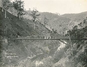
A bridge over the Thomson River, pictured in 1910.
|
|
| Native name | Tambo, Carrang-carrang, Carran-carran |
| Country | Australia |
| State | Victoria |
| Region | South East Coastal Plain (IBRA), West Gippsland |
| Local government area | Shire of Wellington |
| Settlements | Heyfield, Sale |
| Physical characteristics | |
| Main source | Baw Baw Plateau, Great Dividing Range near Newlands 972 m (3,189 ft) 37°44′45″S 146°10′42″E / 37.74583°S 146.17833°E |
| River mouth | confluence with the Latrobe River near Sale 2 m (6 ft 7 in) 38°8′45″S 147°5′11″E / 38.14583°S 147.08639°E |
| Length | 170 km (110 mi) |
| Basin features | |
| River system | West Gippsland catchment |
| Tributaries |
|
The Thomson River is a river in the Gippsland region of Victoria, Australia. It's a river that flows all year round and is part of the West Gippsland water system.
Contents
Where is the Thomson River Located?
The Thomson River starts high up in the mountains, near a place called Newlands. This area is at the northwestern end of the Baw Baw Plateau, which is part of the Great Dividing Range. The water here also feeds the Yarra and Tanjil rivers.
From its source, the river flows in many directions, first north, then east, and then mostly southeast and east. Along its journey, 17 smaller rivers and streams join it. These include the Jordan, Aberfeldy, and Macalister rivers. Finally, it meets the Latrobe River near Sale. The river drops about 970 meters (3,182 feet) over its 170-kilometer (106-mile) journey.
History of the Thomson River Valley
The Thomson Valley was a very important place for gold mining in the late 1800s and early 1900s. A prospector named "Ned" Stringer found a lot of gold in the area now known as Stringers Creek. A short distance up that creek, the gold mining town of Walhalla was built.
In 1959, a man named Ronald Le Sage was the first person to walk the entire length of the river. He was exploring if it could be used as a path for moving cattle.
Thomson Dam and Water Supply
Not far from where the river starts, it is held back by the Thomson Dam. This creates the Thomson Reservoir, which is a huge lake. This reservoir holds about 70% of the water stored for Melbourne, Victoria's capital city. It supplies about 30% of Melbourne's daily water needs.
Taking so much water (about half of the river's natural flow) puts a lot of stress on the environment downstream. This especially affects the Gippsland Lakes, which include Lake Wellington, Lake Victoria, and Lake King. This area is very important and is recognized internationally as a Ramsar wetland site.
Thomson River Diversion Tunnel
There's a special tunnel called the Thomson River Diversion Tunnel near where the river meets Coopers Creek. It's about 4 kilometers (2.5 miles) southwest of Walhalla. This tunnel is 170 meters (558 feet) long and is listed as a Victorian heritage site.
Work on the tunnel began in August 1911 and finished around October 1912. It's one of 13 river diversion tunnels that are still around from the time of the Victorian gold rush. These tunnels were built to change the flow of rivers so miners could get to the gold in the riverbeds.
What's in a Name?
In the Australian Aboriginal Brataualung language, the Thomson River has two names. One is Tambo, but its meaning isn't known. The other is Carrang-carrang or Carran-carran, which means "brackish water" (water that is a bit salty).
The river got its English name in 1840 from Angus McMillan. He named it after Sir Edward Deas Thomson, who was the Chief Secretary of the Colony of New South Wales at the time.
 | Frances Mary Albrier |
 | Whitney Young |
 | Muhammad Ali |


