Yarra River facts for kids
Quick facts for kids Yarra |
|
|---|---|

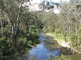
The Yarra River through Pound Bend near Warrandyte.
|
|
| Native name | Berrern Birr-arrung Wongete Yarro-yarro |
| Country | Australia |
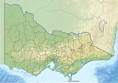
| State | Victoria |
| Region | South Eastern Highlands (IBRA), Central Victoria |
| LGA | City of Hobsons Bay City of Port Phillip City of Melbourne City of Yarra City of Darebin City of Boroondara City of Banyule City of Manningham Shire of Nillumbik Yarra Ranges Shire |
| City | Melbourne |
| Physical characteristics | |
| Main source | Yarra Ranges, Great Dividing Range within Yarra Ranges National Park 792 m (2,598 ft) 37°44′57″S 146°8′26″E / 37.74917°S 146.14056°E |
| River mouth | Hobsons Bay, Port Phillip near the suburb of Port Melbourne 0 m (0 ft) 37°51′7″S 144°54′30″E / 37.85194°S 144.90833°E |
| Length | 242 km (150 mi) |
| Basin features | |
| River system | Port Phillip and Western Port catchment |
| Basin size | 4,078 km2 (1,575 sq mi)50% |
| Tributaries |
|
| National park | Yarra Ranges NP, Royal Botanic Gardens |
The Yarra River is a famous river in Victoria, Australia. It's also known by other names like the Yarra Yarra River and several Indigenous names such as Berrern, Birr-arrung, and Birrarung. This river flows all year round, starting in the east-central part of Victoria.
The Yarra River begins in the Yarra Ranges and travels about 242 kilometers (150 miles) west. It flows through the beautiful Yarra Valley before reaching the wider plains of Greater Melbourne. Finally, it empties into Hobsons Bay, which is part of Port Phillip.
For thousands of years, the river was a very important source of food and a meeting place for indigenous Australians. They called it Birrarung. The name "Yarra" came from a misunderstanding of another Indigenous term, Yarro-yarro, which means "ever-flowing".
When European settlers arrived, they used the river for farming. Over time, the river's shape and surroundings have changed a lot. Parts of it were made wider, and dams like the Upper Yarra Reservoir were built. These changes help protect Melbourne from big floods. Today, the Yarra River is celebrated every year during the Moomba festival in Melbourne.
Contents
Where Does the Yarra River Flow?
The Yarra River starts high up in the Yarra Ranges, which are part of the Great Dividing Range. This area is a national park, full of nature. From there, the river flows downhill, collecting water from many smaller streams and creeks.
As it moves west, the Yarra passes through different types of land. It goes through forests and valleys, then opens up into flatter areas as it gets closer to the big city of Melbourne. The river ends its journey by flowing into Hobsons Bay, which is a part of Port Phillip. This is where the river meets the sea.
Who First Lived by the Yarra River?
Long before European settlers arrived, the Yarra River was home to many Indigenous Australian groups, especially the Wurundjeri people. For them, the river was much more than just water. It was a vital part of their lives.
The river provided food like fish, eels, and birds. It was also a special place for gatherings, ceremonies, and trade. The Wurundjeri people had their own names for the river, including Birrarung. This shows their deep connection and respect for the land and its waterways.
How Has the Yarra River Changed Over Time?
Since 1835, when European settlers began to arrive, the Yarra River has seen many changes. At first, settlers used the river's water and land for agriculture. They grew crops and raised animals near its banks.
To help prevent floods and make it easier for boats to travel, parts of the river were made wider. Dams were also built, such as the Upper Yarra Reservoir. These dams help control the water flow and store water for Melbourne.
As Melbourne grew into a city, industries developed along the river. This led to changes like the destruction of marshlands where the Yarra and Maribyrnong Rivers met. Today, efforts are made to keep the river clean and healthy for everyone to enjoy.
Celebrating the Yarra River
The Yarra River is a central part of Melbourne's identity. Every year, the city holds the Moomba festival, which is one of Australia's largest community festivals. Many of the festival's events, like water skiing and boat races, take place on the Yarra River.
The river is also a popular spot for walking, cycling, and relaxing. Paths run along its banks, offering great views of the city skyline and natural areas. It's a place where people can connect with nature right in the middle of the city.
Images for kids
-
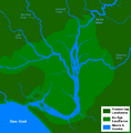
The course of the Yarra River around 10,000 years ago, after the end of the last Ice Age, prior to the creation of Port Phillip.
-
Melbourne is the largest settlement that the Yarra flows through. The Yarra at central Melbourne is shown here at night, with the central business district on the left and Southbank on the right
-
The Yarra River as it flows north-west towards central Melbourne, passing underneath the Swan Street Bridge.
-
Yarra crossing punt road, Melbourne, 1838. by W. Liardet
-
Artificial fish on the Yarra during 2006 Commonwealth Games
See also
 In Spanish: Río Yarra para niños
 | Precious Adams |
 | Lauren Anderson |
 | Janet Collins |


