
Maribyrnong River facts for kids
Quick facts for kids Maribyrnong |
|
|---|---|

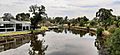
The Maribyrnong River as it flows past the Melbourne suburb of Essendon West
|
|

Contour map of the river basin
|
|
| Native name | Mareingalk, Mirrangbamurn |
| Other name(s) | Salt Water River |
| Country | Australia |
| State | Victoria |
| Region | North–western Melbourne |
| City | Melbourne |
| Physical characteristics | |
| Main source | Macedon Ranges, Great Dividing Range |
| River mouth | confluence with the Yarra River Yarraville 0.2 m (7.9 in) 37°49′14″S 144°54′25″E / 37.82056°S 144.90694°E |
| Length | 40 km (25 mi) |
| Basin features | |
| River system | Port Phillip catchment |
| Basin size | 1,450 km2 (560 sq mi) |

The Maribyrnong River is a river that flows all year round. It's found in the northwestern part of Melbourne, in the Australian state of Victoria. This river is part of the larger Port Phillip area.
Contents
- River's Journey: Where the Maribyrnong Flows
- River Features and Tributaries
- River's Name: What Maribyrnong Means
- History of the Maribyrnong River Valley
- Fun Activities on the Maribyrnong River
- River Crossings: Bridges and Fords
- Animals and Plants of the Maribyrnong River
- Environmental Challenges for the River
- Images for kids
River's Journey: Where the Maribyrnong Flows
The Maribyrnong River starts its journey near Mount Macedon. This area is part of the Macedon Ranges, which is a section of the huge Great Dividing Range.
The river is formed when two creeks, Jackson Creek and Deep Creek, join together. This happens near Taylors Lakes. From there, the Maribyrnong River flows mostly south. It gets bigger as two smaller streams, called tributaries, add their water to it.
Finally, the Maribyrnong River meets the Yarra River at Yarraville. Together, their waters flow into Port Phillip Bay. The river drops about 42 metres (138 ft) over its 40-kilometre (25 mi) length.
River's Beginning: Headwaters and Creeks

The Maribyrnong River's source is in the Macedon Ranges. This region is about 60 kilometres (37 mi) northwest of Melbourne City Centre. Many small creeks from southern Mount Macedon flow into Riddells Creek. Riddells Creek then flows into Jackson Creek.
Jackson Creek starts its journey northwest of Gisborne, about 50 kilometres (31 mi) north of Melbourne's city center. The other main stream that feeds the Maribyrnong is Deep Creek. Deep Creek also begins in the northern and eastern parts of the Macedon Ranges.
Deep Creek has carved a deep valley through the flat basalt plains. You can see this as it flows through places like Konagaderra and Bulla. West of Melbourne Airport, Jackson Creek and Deep Creek meet to form the Maribyrnong River.
You can visit the Organ Pipes National Park right next to Jackson Creek. It's near the Calder Freeway. Here, you'll find picnic areas and amazing basalt columns. These rock formations look just like organ pipes!
Middle Part of the River: Horseshoe Bend and Parks

As the river flows south and west, it reaches Keilor. Here, the river makes a huge horseshoe-shaped bend before turning south again at Brimbank Park. In this area, the river flows 55 metres (180 ft) below the western plains.
Brimbank Park is like a giant outdoor theater formed by the river's bend. It has picnic spots, bike and walking trails, and a café. It's a popular place on weekends. The park is also home to many birds and native animals.
The Maribyrnong River Trail is a shared path that starts at Brimbank Park. It follows the river almost all the way to where it joins the Yarra River in Footscray. In areas like Avondale Heights and Essendon West, people have great views of the river valley and the tall buildings of Melbourne's city center.
River's End: Lower Reaches and City Views

The river flows past Pipemakers Park in Maribyrnong. This park includes Melbourne's Living Museum of the West. The museum shares information about the river's history and the early factories that were once here.
Sometimes, you can spot dolphins in the lower parts of the river. Many water birds also live here, especially at Burndap Park. Footscray Park is just a short distance downstream from Pipemakers Park and Burndap Park. It's located across from the famous Flemington Racecourse. The river then winds its way across the flat land until it meets the Yarra River at Yarraville.
River Features and Tributaries
The Maribyrnong River has several interesting geographic features and streams that flow into it. The main streams that join the river are listed below in bold.
The Maribyrnong River is a stream that flows into the Yarra River.
- Yarraville Wharves
- Maribyrnong Berth
- Newells Paddock Wetlands
- Burndap Lakes
- Jacks Canal
- Frogs Hollow Wetland
- Cliffs
- Steele or Rose Creek
- Grimes Flat
- Kulin Wetlands
- Taylors Creek
- Horseshoe Bend
- Gumms Corner
- Unnamed Creek
- Jackson Creek / Deep Creek
River's Name: What Maribyrnong Means
Early European settlers first called the river Saltwater River. This was because the lower parts of the river were affected by the ocean's tides, making the water salty.
The name Maribyrnong comes from the Woiwurrung language. This was the language of the local Wurundjeri people. It might mean "I can hear a ringtail possum" (mirring-gnay-bir-nong). Another idea is that it means "saltwater river." In Woiwurrung, Gunung or Gunnung means river. You can see this in other local river names like Koonung Creek and Birrarung.
An older spelling, Marriburnong, was shown on a map from 1840. The river has given its name to the suburb of Maribyrnong and the local government area, the City of Maribyrnong.
History of the Maribyrnong River Valley
The Maribyrnong River valley has been home to the Wurundjeri people for a very long time, possibly up to 40,000 years. Scientists have found human remains along the river that are at least 15,000 years old. There are also even older signs that people lived here.
The first Europeans to explore the river were led by Charles Grimes in February 1803. John Batman probably explored the river in early 1835. After the colony of Melbourne was started later that year, sheep farms were set up.
One important crossing point was Solomon's Ford, near Canning Street in Avondale Heights. This was the lowest place to cross the river and the furthest inland where the tide reached. It was the main way to get from Melbourne to Geelong and the land to the west for many years.
In the late 1800s, many factories were built along the river. This caused the water to become very polluted. Since the 1960s and 1970s, many of these factories have closed. Now, much of the land along the river has been turned into parks and places for homes.
Fun Activities on the Maribyrnong River
| Maribyrnong River Bike Path | |
|---|---|

Maribyrnong River at Footscray looking towards Melbourne CBD.
|
|
| Length | 50km |
| Location | City of Maribyrnong, Melbourne, Victoria, Australia 3012 |
| Cycling details | |
| Trail difficulty | Easy |
The Maribyrnong River is very important for fun activities in Melbourne. People enjoy boating on the river. Many also love cycling along its bike paths, like the Maribyrnong River Trail.
Fishing and walking are also popular. You can even do some light bushwalking and watch for Australian native animals. You might see echidnas, wallabies, possums, and flying foxes.
River Crossings: Bridges and Fords
Many roads and railways cross the Maribyrnong River. Here are some of the bridges and crossing points:
- Shepherd Bridge (a main road)
- South Kensington-West Footscray railway
- Hopetoun Bridge (a main road)
- Suburban railway to Footscray
- Former stock bridge (moved from Punt Road)
- Lynchs Bridge (a main road)
- Farnsworth Avenue Bridge (a smaller road)
- Pipemakers Park Footbridge (for walking)
- Maribyrnong Road Bridge (a main road)
- Afton Street Footbridge (for walking)
- Canning Street Bridge (built in 1970)
- Medway Golf Club Footbridge (for walking)
- Solomons Ford (an old, historic crossing point)
- Maribyrnong River Viaduct (for the Albion-Jacana railway)
- E.J. Whitten Bridge (Western Ring Road)
- Two Fords (shallow river crossings)
- Old Calder Highway Bridge (a main road)
- Historic Calder Bridge (built 1868)
- Calder Freeway Bridge
- Flora Street Bridge (a local road)
- Historic Arundel Road Bridge (built 1906-7, now closed)
- Arundel Road Bridge (built 1989)
Animals and Plants of the Maribyrnong River


Native Animals: Who Lives Here Naturally?
Many native animals live along the Maribyrnong River.
- Mammals: You can find swamp wallabies, grey-headed flying foxes, common brushtail possums, common ringtail possums, water rats, echidnas, and even platypus in the upper parts of the river.
- Reptiles: Native reptiles include eastern brown snakes, tiger snakes, skinks, and common snakeneck turtles.
- Birds: Many native birds fly around, such as the eastern whipbird, cockatoo, rainbow lorikeet, galah, brown falcon, peregrine falcon, square-tailed kite, royal spoonbill, black swan, Pacific black duck, little pied cormorant, moorhen, and long-billed corella.
- Fish and Frogs: There are also various native frogs and fish. Native fish include the short-finned eel, tupong, short-headed lamprey, Australian grayling, southern black bream, common galaxias, broad-finned galaxias, and spotted galaxias. You might even find Starfish in the river!
Introduced Animals: Newcomers to the River
Some animals have been brought to the area by people and are not native.
- Mammals: These include the red fox, European rabbit, and feral cat.
- Birds: Introduced birds are the song thrush, common blackbird, common myna, common starling, house sparrow, spotted turtle dove, rock pigeon, and mallard.
- Fish: Common carp have also been introduced to the river.
Environmental Challenges for the River
The Maribyrnong River faces some environmental challenges. Besides the introduced animal species, there is also pollution and contamination. This includes things like arsenic and heavy metals from old industries. Litter is also a problem, but there are traps to help stop it from entering the river from stormwater drains.
Images for kids
-
The river as seen from the Maribyrnong Road Bridge

