Jackson Creek (Victoria) facts for kids
Quick facts for kids Jackson |
|
|---|---|

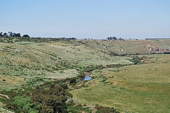
The narrow valley cut by Jackson Creek near Clarkefield
|
|

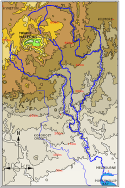
Contour map of the Maribyrnong River basin; Jackson Creek rises midpoint between the 400–500-metre (1,300–1,600 ft) contour line.
|
|
| Other name(s) | Saltwater River Western Branch, Gisborne Creek, Macedon River, Saltwater River, Saltwater Creek |
| Country | Australia |
| State | Victoria |
| Region | Victorian Midlands (IBRA), Greater Melbourne |
| Local government area | Macedon Ranges Shire |
| Suburbs | Gisborne, Sunbury |
| Physical characteristics | |
| Main source | Macedon Ranges, Great Dividing Range |
| River mouth | confluence with the Deep Creek to form the Maribyrnong River west of Melbourne Airport 42 m (138 ft) 37°40′10″S 144°48′16″E / 37.66944°S 144.80444°E |
| Length | 71 km (44 mi) |
| Basin features | |
| River system | Port Phillip catchment |
| Tributaries |
|
| National park | Organ Pipes NP |
Jackson Creek is a flowing waterway located in the northern suburbs of Melbourne, Australia. It's part of the larger Port Phillip catchment area, which means its waters eventually flow into Port Phillip Bay.
Contents
Where Jackson Creek Flows
Jackson Creek starts where three smaller streams – Distill, Gisborne, and Slaty creeks – join together. These streams collect water from the southern parts of the Macedon Ranges, which are part of the Great Dividing Range. The creek begins near Gisborne, inside the Rosslynne Reservoir.
From its source, Jackson Creek flows east, then turns south. It is joined by two more small streams along the way. Eventually, it meets up with Deep Creek to form the Maribyrnong River. This meeting point is west of Melbourne Airport.
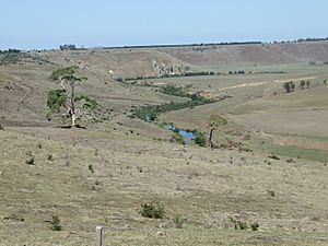
In its early sections, the creek flows through a wide, shallow valley near Bullengarook. As it continues, the valley becomes deeper and narrower. The creek passes through the town of Gisborne before heading south towards Sunbury. It then joins Deep Creek south of Bulla, forming the Maribyrnong River.
The deep valley carved by Jackson Creek is very noticeable in places like Emu Bottom and the Organ Pipes National Park. Over its 71-kilometre (44 mi) journey, the creek drops about 417 metres (1,368 ft) in elevation.
Cool Rock Formations
The way Jackson Creek has cut through the land shows how the newer volcanic rocks have been worn down over time. This has created interesting features like rapids and small waterfalls. You can also see cool rock formations called columnar basalts and tessellated pavements.
A great example is at the Organ Pipes National Park, near the Calder Freeway. Here, you can see tall, straight basalt columns that look just like the pipes of a giant organ. Further upstream, near Sunbury, an old bluestone flour mill used the creek's drop in water level to power its machinery.
Why is it Called Jackson Creek?
The creek was named after two early settlers, William and Samuel Jackson. Samuel Jackson also named the town of Sunbury in 1857, after Sunbury-on-Thames in England.
Sometimes, Jackson Creek is thought of as the western branch of the Maribyrnong River. This is because Deep Creek is often called the eastern branch. Over time, the creek has had other names too, like Saltwater River Western Branch, Gisborne Creek, and even Macedon River.
Bridges and Crossings
Many bridges and crossing points allow people to get over Jackson Creek. Here are some of the important ones:
- Holden Bridge (an early concrete bridge)
- Jacksons Creek bridge (in Sunbury, an old bluestone bridge for walkers)
- Sunbury railway viaduct (built in 1859 for the Bendigo train line)
- Black Hill Bridge (on Settlement Road)
- Old Jacksons Creek Bridge (for walkers only)
- Jacksons Creek Bridge (on Riddell Road)
- Calder Freeway
- Gisborne - Kilmore Road
- Aitken Street
- Waterloo Flat Road
 | Frances Mary Albrier |
 | Whitney Young |
 | Muhammad Ali |


