
Merri Creek facts for kids
Quick facts for kids Merri Creek |
|
|---|---|

The Merri Creek passing through Fairfield and Clifton Hill with Melbourne city skyline in the distance.
|
|
| Country | Australia |
| State | Victoria |
| Physical characteristics | |
| Length | 70 km (43 mi) |
| Basin features | |
| Basin size | Unknown |
The Merri Creek is a cool waterway (a small river) in Victoria, Australia. It flows through the northern parts of Melbourne. It starts near Wallan, north of Melbourne, and flows south for 70 kilometers (about 43 miles). It then joins the Yarra River at a spot called Dights Falls. This area, where the creek meets the Yarra River, was a special meeting place for the Wurundjeri people, who are the traditional owners of this land. It might even be where one of Australia's first land agreements, called Batman's Treaty, happened between Indigenous Australians and early European settlers.
For a long time in the 1900s, the creek was used by factories and quarries. Sadly, this meant a lot of pollution, like heavy metals and grease, got into the water. This hurt the plants and animals living near the creek. But don't worry! In recent years, many people and groups have worked hard to clean up the creek. They've planted new trees and plants and are helping the creek's environment get healthy again.
Contents
What Merri Creek Means
The name 'Merri Creek' comes from the Wurundjeri-willam language. Their phrase Merri Merri means "very rocky". Early European settlers later shortened this to Merri Creek.
Where Merri Creek Flows

The Merri Creek was formed over many, many years. Long ago, volcanoes like Mount Fraser erupted. They sent lava flowing into the old valleys of the Merri and Darebin Creeks. Over time, the Merri Creek cut its way through this hardened lava.
Today, the creek begins in Wallan and flows south for 70 kilometers. It joins the Yarra River in Fairfield near Dights Falls. From there, the water eventually flows into Port Phillip.
The Merri Creek has several smaller streams that flow into it. These are called tributaries. Some of them include Wallan Creek, Taylors Creek, and Edgars Creek. The creek also flows through or forms the edge of many suburbs. These include Wallan, Craigieburn, Epping, Coburg, Preston, Northcote, and Fairfield.
Cool Rocky Cliffs
One interesting spot along the Merri Creek is a rocky cliff face. You can see it on the eastern side of the creek in Clifton Hill. It has tall, cracked columns of basalt rock. These columns were formed when hot lava cooled down. You can also see rocks that have fallen into the stream. This shows how the weather has worn down the cliff over time.
Plants and Animals of Merri Creek
As people have replanted native plants, some amazing wildlife has returned! You might spot Kookaburras, Kingfishers, and Yellow-tailed Black Cockatoos. Echidnas and frogs also live here. There have even been sightings of platypuses! They were first seen in the northern parts and now even further south in Coburg.
The Merri Creek area also has many edible plants. These include dandelion, fennel, and nettle. However, it's very important to be careful! Some dangerous plants, like Poison hemlock, can look similar to edible ones. Always have an expert with you if you are looking for edible plants.
Merri Creek History
Many old sites show that Indigenous Australians used this area a lot. The creek and its valley were important places for large gatherings of Aboriginal people. It might also be where one of the first land agreements between Aboriginal people and Europeans happened.
Old Discoveries
Archaeologists have found many interesting things along the creek. They've found stone tools from old campsites. They've also found "scarred trees." These are trees where traditional people removed bark to make canoes, containers, or shields. These discoveries help us learn about the hunting and gathering way of life from long ago. These sites are very special and are protected by the Aboriginal Heritage Act 2006.
Before Europeans Arrived

The Wurundjeri-willam people were the first inhabitants of what is now northern Melbourne. Their name comes from the Aboriginal word Wurrun, meaning "white gum tree". The Wurundjeri-willam were a group of families. A respected elder named Billibellary was an important leader during the first years of contact with Europeans. His group lived on the northern bank of the Yarra River. Their land stretched north along the Merri Creek.
The creek gave the Wurundjeri-willam plenty of food. They found eels, fish, and ducks. Women would wade in the Merri Creek with string bags. They would search the bottom for shellfish. They also hunted emus and kangaroos in the grasslands nearby. In the forests, possums were a key source of food and clothing. Possum meat was cooked, and their skins were sewn into warm, waterproof cloaks.
After Europeans Arrived

In May 1835, a very important meeting took place. John Batman met with important leaders of the Wurundjeri-willam and other groups. Billibellary and the other elders signed a document. This document became known as Batman's Treaty. It was the only agreement ever made between European settlers and Indigenous Australians about land. Batman wrote that these talks happened by a "lovely stream of water." Historians believe this stream was the Merri Creek.
However, the Governor of New South Wales, Sir Richard Bourke, later said this treaty was not valid. He did not want to let Aboriginal people control their own land. This led to the idea of terra nullius, meaning "land belonging to no one."
The biggest recorded meeting of Aboriginal people in Victoria happened at Merri Creek in January 1844. The Wurundjeri-willam hosted a huge gathering of tribes. About 800 people came from all over central Victoria. They came to witness important legal proceedings. These were carried out according to traditional Aboriginal law.
Since European settlement, the lower parts of the creek have been badly damaged. Early in Melbourne's history, many quarries were built along the creek. They dug out bluestone rock. This bluestone was used to build many city buildings and pave roads. Later, these quarries were used as landfills for trash. Also, many non-native plants, like prickly pear and willows, grew along the banks. stormwater from suburban streets flowed directly into the creek. This brought rubbish and other pollution.
Cleaning Up Pollution

In recent years, a lot has been done to help the creek. Some areas still have native plants. People are working to remove weeds and use controlled burning to help these plants grow better. Many native plants have been replanted by groups like the Merri Creek Management Committee and the Friends of Merri Creek.
Melbourne Water has also been removing willow trees. This helps the water flow better and allows native plants to grow. Sometimes, treated water from a sewage plant is added to the creek when the water level is low. This helps keep water in the creek.
For a long time, people thought the water quality was too poor for platypuses to live there. This was because pollutants like heavy metals and grease from factories had hurt the tiny creatures that platypuses eat. But in September 2010, a platypus was seen between Thornbury and Coburg! This was the first sighting in decades and a great sign of improvement.
Fun at Merri Creek
Parks Victoria manages some parklands along the creek. These parks have football and cricket fields, tennis courts, and playgrounds. The Merri Creek Trail is a path along the banks for walking and cycling. It's a great way to enjoy the improving environment. Each year, the CERES Community Environment Park hosts festivals like the Return of the King and Harvest Festivals. These are celebrated right on the creek's banks.
Protecting Merri Creek
The Merri Creek and Environs Strategy 2009-2014 helps guide how the creek's waterways are managed. There's also a plan to create a 2,500-hectare park along the creek. This park would help protect and restore the plants and animals that live near the water.
Bridges
| Coordinates | Name | Usage | Description | Photo |
|---|---|---|---|---|
| 37°44′47″S 144°58′49″E / 37.746466°S 144.980180°E | Cable Suspension Bridge - between Coburg and Preston, also known as Harding st bridge | Pedestrians and cyclists | This is the only suspension bridge on the Merri Creek. It opened in 1985. It replaced an older bridge built in 1925. | |
| 37°46′59″S 144°59′36″E / 37.782983°S 144.993197°E | - | - | - |


Images for kids
-
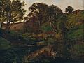
Evening, Merri Creek, painted by Julian Ashton in 1882, is thought to be the first true plein air painting done in Australia.
-
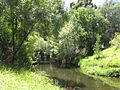
The Merri Creek, through Preston.
-
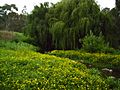
The Merri Creek in Coburg.
-
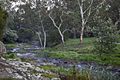
Merri Creek at Lake Reserve Coburg April 2021.


