
Moonee Ponds Creek facts for kids


The Moonee Ponds Creek is a small river, or creek, that flows through Melbourne, Victoria, Australia. It's a main branch of the Yarra River. In 2004, a newspaper reporter called it "arguably the most abused tributary of the Yarra River". This means it was seen as one of the most damaged waterways connected to the Yarra.
The creek starts in the countryside near Greenvale. It then flows across flat lands around Woodlands Historic Park, which is just north of Melbourne Airport. As it gets closer to the Yarra River, it passes between higher areas like Essendon and Royal Park. Through many city areas, it looks more like a concrete storm drain than a natural creek.
The Moonee Ponds Creek flows through many suburbs. These include Westmeadows, Meadow Heights, Tullamarine, Broadmeadows, Gowanbrae, Glenroy, Strathmore Heights, Oak Park, Strathmore, Pascoe Vale, Pascoe Vale South, Essendon, Brunswick West, Moonee Ponds, Ascot Vale, Flemington, Parkville, and North Melbourne. In North Melbourne, a wider part of the creek is called Railway Canal. Finally, it joins the Yarra River at Melbourne Docklands.
Contents
Moonee Ponds Creek: A Look at Its Past
Early Days: Before European Settlement
Before people from Europe settled in Australia, the Wurundjeri People of the Kulin nation lived along the Moonee Ponds Creek. The creek might have been named after an Indigenous person called Moonee Moonee. He, along with Tullamareena, famously escaped from Melbourne's first jail in 1838.
European settlers first arrived in the Port Phillip area in 1835. The first pieces of land were sold near Strathmore, along the Moonee Ponds Creek, in 1843 and 1845.
Changes to the Creek Over Time
The creek used to have many marshy ponds and large saltwater marshes near where it met the Yarra River. These marshes were known as Batman's Lagoon. As Melbourne grew very quickly during the Victorian gold rush in the 1850s, the swamp became a place where waste water from nearby suburbs was dumped.
In 1879, Batman's Lagoon was drained and filled in. This was done to build the North Melbourne railway yards. The southern part of the filled-in marshes was called Dudley Flats. During the 1930s Great Depression, poor people used materials from the landfill to build simple shelters there.
In the 1890s, the lower part of Moonee Ponds Creek was used like a canal. Barges carried coal along it to the North Melbourne Locomotive Depot.
Modern Changes and Concrete Channels
In the 1950s and 1960s, the Melbourne Metropolitan Board of Works (now called Melbourne Water) straightened and lined parts of the creek with concrete. This was done from Strathmore to Flemington Road to try and stop floods. These changes were part of a big plan to develop the areas near the creek. Today, for much of its length through the northern suburbs, it looks like a concrete stormwater drain that runs next to the Tullamarine Freeway.
Working to Improve the Creek Today
In 1998, the Moonee Ponds Creek Co-ordination Committee Inc (MPCCC) was started. This group helps plan, restore, and protect the creek. Its members include the local councils of Hume, Moreland, Moonee Valley, and Melbourne. The "Friends of Moonee Ponds Creek" group is also a member. The MPCCC works closely with other important groups like Melbourne Water and Parks Victoria.
In 2002, the end of the creek was moved. This was to make space for new developments at Victoria Dock in the Port of Melbourne. The creek's mouth, which used to be near Appleton Dock, was removed. A new path for the water was dug directly south, next to the Bolte Bridge. This change created a space between the port and the new homes and businesses at Melbourne Docklands. Even though moving waterways is not usually preferred, this work was allowed because the creek had already been changed so much in that area.
Protecting and Enjoying Moonee Ponds Creek
Efforts to Improve the Creek's Health
In recent years, work has been done to make the creek healthier. This includes improving habitats, reshaping the banks, and planting new plants. In 2005, the water quality, aquatic life, and water flow were all rated as poor. The plants were rated as very poor. However, the habitat and stability of the creek banks were rated as good.
In 2004, a big project began to improve stormwater in the creek's area. Wetlands were built at Jacana, and special traps were installed to catch litter. Thanks to recent efforts to protect the habitat, some wildlife is returning to the creek. This includes the pobblebonk frog near Strathmore Secondary College, and the nankeen night heron in the upper parts of the creek.
Exploring the Moonee Ponds Creek Trail
Along the entire length of the Moonee Ponds Creek, there is a shared path called the Moonee Ponds Creek Trail. This path is great for cyclists and walkers. It starts at Melbourne Docklands and goes all the way to Woodlands Homestead within Woodlands Historic Park. The trail connects many reserves, parks, and sporting grounds along the creek, making it easy for people to enjoy the outdoors.
Images for kids
-
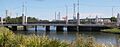
Dynon Road bridge
-
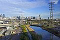
Railway Canal near 37 Dynon Rd at North Melbourne.

