Latrobe River facts for kids
Quick facts for kids Latrobe |
|
|---|---|

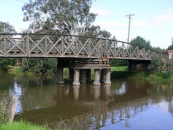
The Sale Swing Bridge over the Latrobe River.
|
|
| Native name | Durt'yowan, Tanjil |
| Other name(s) | La Trobe, LaTrobe |
| Country | Australia |
| State | Victoria |
| Region | South East Coastal Plain (IBRA), West Gippsland |
| Local government areas | Baw Baw, Wellington, East Gippsland |
| Physical characteristics | |
| Main source | Baw Baw plateau, Great Dividing Range below Dick Hill, near Noojee 764 m (2,507 ft) 37°49′33″S 145°47′39″E / 37.82583°S 145.79417°E |
| River mouth | Lake Wellington east of Sale 1 m (3 ft 3 in) 37°54′11″S 147°37′20″E / 37.90306°S 147.62222°E |
| Length | 270 km (170 mi) |
| Basin features | |
| River system | West Gippsland catchment |
| Tributaries |
|
| National parks | The Lakes NP, Gippsland Lakes CP |
The Latrobe River is an important river in Victoria, Australia. It's also sometimes called La Trobe or LaTrobe. This river flows all year round and is a big part of the West Gippsland area. It helps fill the beautiful Gippsland Lakes by collecting water from the southeastern side of the Great Dividing Range.
River's Journey and Features

The Latrobe River starts high up on the southern slopes of the Baw Baw plateau. This area is part of the Great Dividing Range, near the towns of Powelltown and Noojee. The river begins below a place called Dick Hill.
The river flows for about 270 kilometers (168 miles). It generally moves east, then south, and then east again. It travels through the Latrobe Valley, picking up water from many smaller rivers and streams. These smaller rivers are called tributaries.
Some of its important tributaries include the Ada, Toorongo, Loch, Tanjil, Morwell, Tyers, and Thomson rivers. Eventually, the Latrobe River reaches its mouth in Lake Wellington, east of Sale. Here, it joins with the Avon.
From Lake Wellington, the river continues into Lake Victoria. In Lake Victoria, it meets Forge Creek and the Mitchell River. Finally, the Latrobe River empties into Bass Strait near Lakes Entrance. The river drops 764 meters (2,507 feet) from its source to its mouth.
Lakes and Parks Along the River
The Latrobe River flows through a few important lakes. One is Lake Narracan, which is a storage reservoir near Newborough. This lake helps provide cooling water for nearby power stations. The river also flows through Lake Victoria before reaching the ocean.
In its upper parts, the Latrobe River runs next to special natural areas. These include the Noojee Streamside Reserve and the Tyers Streamside Reserve. Closer to its mouth, the river flows near The Lakes National Park and the Gippsland Lakes Coastal Park. These parks help protect the natural environment around the river.
Naming the Latrobe River
The Latrobe River has a rich history, including its names. In the Australian Aboriginal Brataualung language, the river has two names. One is Durt'yowan, which means "finger." The other name is Tanjil, but its meaning is not clearly known.
Later, in 1841, an early settler named William Adams Brodribb named the river. He chose the name to honor Charles La Trobe. Charles La Trobe was the Lieutenant Governor of the Port Phillip District at that time.
Some records also suggest that Angus McMillan discovered the river in 1840. He might have called it the Glengarry River. Today, the Australian Government usually calls it La Trobe River. However, the Victorian Government officially lists it as Latrobe River.
 | Anna J. Cooper |
 | Mary McLeod Bethune |
 | Lillie Mae Bradford |


